Tampico, Tamaulipas 作者: 来源: 发布时间:2021-07-22
1.Basic data
Pop.: 314,418
Area: 92.73 km2
Elev.: 10 masl
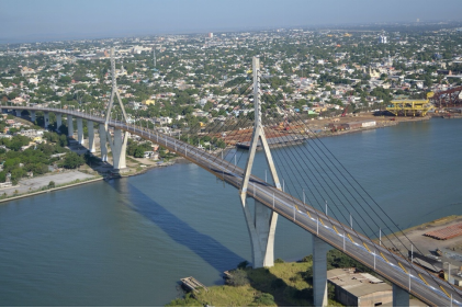
2. Natural geography
Tampico is privileged as far as fauna is concerned, its geographical location allows it to have a great variety of animal species.
In an area of approximately 150 ha, which includes the estuarine and terrestrial aquatic environment, in the heart of the city, the Laguna del Carpintero constitutes a territory that, despite being subjected to constant urban pressure, has a great variety of animal species. The Laguna del Carpintero is connected by the Canal de la Cortadura with the Pánuco River, the lagoon has a maximum depth of 6 meters.
The Morelet's crocodile (Crocodylus moreletii) inhabits the Laguna del Carpintero, which makes this point of the city one more attraction. Steve Irwin ("The Crocodile Hunter") made a trip to La Laguna del Carpintero to document an investigation on the reptiles that live there, he was a great surprise when he witnessed the enormous preservation capacity of animals by simply fleeing of human beings who approached them.
Tampico is a place where pelicans and ducks from Canada and the United States of America arrive in winter, which can be seen in the Laguna del Chairel and the Tamesí River; Its fauna includes ibis, herons, raccoons, opossums, otters and turtles among other species.
The Laguna de la Vega Escondida is part of the lagoon system of the Tamesí River, being a protected area of 2,217 hectares in which at least twenty-four animal species inhabit, including the otter and four plants, in addition to some endemic animal species.
Weather
Köppen Classification: Tropical Savanna Climate
Tropical savanna climates have monthly mean temperature above 18°C (64°F) in every month of the year and typically a pronounced dry season, with the driest month having precipitation less than 60mm (2.36 in) of precipitation. In essence, a tropical savanna climate tends to either see less rainfall than a tropical monsoon climate or have more pronounced dry seasons than a tropical monsoon climate. Tropical savanna climates are most commonly found in Africa, Asia and South America. The climate is also prevalent in sections of Central America, northern Australia and North America, specifically in sections of Mexico and the state of Florida in the United States.
The Köppen Climate Classification subtype for this climate is "Aw". (Tropical Savanna Climate).
The average temperature for the year in Tampico is 76.6°F (24.8°C). The warmest month, on average, is August with an average temperature of 83.7°F (28.7°C). The coolest month on average is January, with an average temperature of 65.8°F (18.8°C).
The highest recorded temperature in Tampico is 110.3°F (43.5°C), which was recorded in May. The lowest recorded temperature in Tampico is 29.3°F (-1.5°C), which was recorded in December.
The average amount of precipitation for the year in Tampico is 44.3" (1125.2 mm). The month with the most precipitation on average is September with 10.9" (276.9 mm) of precipitation. The month with the least precipitation on average is March with an average of 0.7" (17.8 mm). In terms of liquid precipitation, there are an average of 93.3 days of rain, with the most rain occurring in September with 14.5 days of rain, and the least rain occurring in March with 3.6 days of rain.
https://www.weatherbase.com/weather/weather-summary.php3?s=928111&cityname=Tampico%2C+Tamaulipas%2C+Mexico&units=
Getting there and around
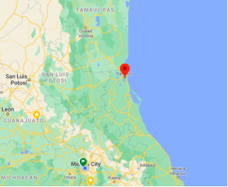
Get in
Tampico is served by General Francisco Javier Mina International Airport (TAM). There is one flight per day to/from Houston via United Airlines, and several others via Monterrey, Guadalajara, Queretaro, Veracruz or Mexico City.
Terminal Central de Autobuses de Tampico is the main bus terminal for the city and has several bus lines serving it.
Alternately, Tampico is located a six-hour drive or bus ride from the Mexican border with either McAllen or Brownsville, Texas, as well as a two to four-hour drive or bus ride to the most iconic places of the Huasteca Potosina.
Get around
Driving is the easiest way to travel around Tampico. Speed limits and red lights are enforced - other laws tend to be rather lax.
Taxis are relatively safe to take in and around Tampico at any time of day or night, but as always, use caution when traveling alone. Due to conflicts with the State policy for passenger transportation, the Uber platform nor any other has arrived to Tampico, but there are several taxi lines with their own platform to use.
3.Economy
GDP: 48,154M MXN (2004)
4. Industry
The metropolitan area is an important gateway for foreign trade, being the only part of Mexico that has two modern ports within a short distance. In the industrial corridor, located to the north of the area, there are important national, international and multinational companies in which the manufacture of polymers for different uses predominates, it also supplies approximately 3,350 MW to the Mexican electricity system. This is how these two ports extend their region of influence to cities such as Monterrey, San Luis Potosí, Aguascalientes and Guadalajara mainly.
Tampico is the headquarters of the First Naval Zone of Mexico. Previously, the region in which Tampico is located was a region rich in oil, however the extraction wells are no longer economically productive, currently dedicating themselves to oil refining, since the Francisco I. Madero refinery is located in Ciudad Madero. with its own docks and a dry dock.
Tampico is the flagship city of an extensive region with little less than a million inhabitants, being the most developed area of the state, a city dedicated mainly to commerce, petrochemical industry and tourist services, meeting; large industrial and commercial chains.
Modernization projects
In recent years the city has been modernizing, carrying out the development of ambitious projects that will support the tourism sector and its citizens, such as those developed by the Tampico Historic Center Trust, which include the restoration of buildings with heritage value, the construction of the Metropolitan Cultural Space inaugurated in 2003, the Canal de la Cortadura project, the Miramar Beach Tourism Development Master Plan in the neighboring municipality of Ciudad Madero, which includes the construction of hotels, subdivisions and residential buildings.
In 2014, seeking to beautify the area of the old maritime customs, the old Kiosk was demolished to make way for the new city square, called "Plaza hijas de Tampico", which is located right next to the new markets, a project which first phase was completed on February 13, 2020.
The Tampico market is one of the largest in Tamaulipas, offering grocery products or even handicrafts, its modification is part of a project in which it is intended to exploit the tourist capacities of the area of the old maritime customs.
A Note on Safety
Before booking your trip to Tampico, ready to discover what the lush tropical city in eastern Mexico has to offer, it’s best to know that the region has experienced its fair share of violence over the past decade. Back in 2014, thousands of people fled into the streets wearing white, carrying white balloons, and waving white handkerchiefs — all as a desperate cry for help. In the years prior, Tampico had witnessed waves of senseless violence ranging from shoot-outs to gas explosions and arson.
What was previously considered a prime spring break destination has now had a dramatic face change. Many buildings are abandoned, and much of the tourist infrastructure has deteriorated. While Tampico used to be driven by a wealthy oil and gas industry, recently it’s most prominent business has been the trafficking of cocaine, marijuana, and methamphetamines to the United States and Mexico City.
Travel to Tampico is currently only advised if necessary, and should only take place for a short period in supported areas.
5. Touristic sites
Starting in the early 20th century, Tampico — a port city on the Gulf of Mexico in the state of Tamaulipas — became a booming oil city rich with European architecture and culture. Due to its curious French influences mixed with native roots, many people considered it the New Orleans of Mexico. While it’s certainly not the vacation destination it once was, it’s still worth a visit for curious travelers. Here are 12 reasons why you should visit Tampico, Mexico.
Historic Center
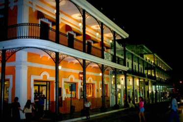
While Tampico’s roots stretch back to pre-colonial eras, the architecture and the overall character of the city is quintessentially European. Influenced by the art movements of the late 19th and early 20th century, in many ways Tampico feels like the New Orleans of Mexico. You can spend the better part of an afternoon strolling through the important landmarks like the Cathedral of Tampico, the old post office, City Hall, and the Cultural Center. Be sure to try the street food too — tortas de la barda are sandwiches made with ham, cheese, beans; shrimp empanadas, or delicious tamales. The Best Mexican Food (Outside of Mexico) will give you some other delicious options that may be closer to home.
Miramar Beach
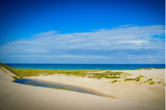
Miramar Beach is without a doubt the most popular tourist attraction in Tampico. On hot days, there’s nothing better than sprawling out on the golden sand and taking a dip in the warm waters of the Gulf of Mexico. There’s over a half mile of unimpeded shoreline, and a paved jetty you can walk out on. The beach hasn’t seen too much development over the years, and many visitors say it retains the same quiet charm as it did over 40 years ago.
Huasteca Culture Museum
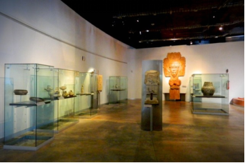
Located within the METRO — the Metropolitan Arts and Entertainment Venue — the Huasteca Culture Museum is the best place to visit for history buffs interested in the indigenous roots of Tampica. Here, you’ll find hundreds of artifacts over 500 years old including statues, clothing, pottery, and paintings. Also learn how the Huastecans extracted crude oil from the ground to use as a dye, which eventually led to Tampico’s reputation as an oil exporting hub during the 20th century.
https://www.alltherooms.com/blog/reasons-visit-tampico-mexico/
Laguna del Carpintero
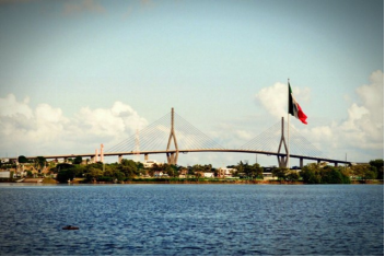
This lake, just 15 minutes from the city center, is Tampico’s most important spot for wildlife and biodiversity. Here, you’ll find all kinds of flora and fauna from crocodiles to migratory birds and woodpeckers, plus much more. A great option is to hop on a boat tour and explore the roughly 37-acre lake.
You can take a boat at La Cortadura walk and it gets you to the lagoon with a guide explaining you all. You can also walk around it as there is a place with lot of Iguanas and other with lots of Crododiles.
https://www.tripadvisor.com.mx/ShowUserReviews-g151928-d4601297-r690198570-Laguna_del_Carpintero-Tampico_Northern_Mexico.html#review690198570
6. History and Culture
The name "Tampico" is of Huastec origin, tam-piko meaning "place of otters" (literally "water dogs"). The city is surrounded by rivers and lagoons of the delta of the Pánuco River, which was the habitat of a large population of otters. There have been successive human settlements in the area for centuries. The region had several early Huastec settlements, among them the important site at Las Flores, which flourished between AD 1000 and 1250.
In 1532, during the Spanish colonial period, the Franciscan priest Andrés de Olmos established a mission and monastery in the area, building over a former Huastec village. At his request, Spanish officials founded a settlement named San Luis de Tampico in 1554. This site was abandoned in 1684, and the population relocated to the south of the Pánuco River because of frequent attacks by European and American pirates. The area was abandoned for nearly 150 years.
The present Mexican city was founded on April 13, 1823 on the north bank of the Pánuco River about 10 kilometers (6 mi) from the Gulf, after Mexico achieved independence from Spain. Tampico built its economy on the exportation of silver; business development was mostly as a trading center and market town of an agricultural region. The town also became a common waypoint for the re-routing of African slaves to be illegally smuggled into the Southern United States, which had outlawed the international slave trade in 1807. In August 1829, Spain sent troops from Cuba to invade Tampico in an effort to regain control of the region, but in September, General Antonio López de Santa Anna forced the Spanish troops to surrender, and Mexican control of Tampico was reestablished.
20th century to present
The first oil well in Mexico was drilled near Tampico at Ébano S.L.P. in 1901, by Californian Edward Doheny, who founded Mexican Petroleum Corporation. In the early 20th century, there was extensive U.S. investment in oil development in Tampico, with a sizable United States expatriate community developing in relation to the industry. With the outbreak of the Mexican Revolution, which lasted roughly from 1910 to 1920, the U.S. monitored the situation to protect its citizens and investments. Doheny sold some of his businesses to the Standard Oil Company which operated its monopoly here. The oil-producing area was so productive it was called the "Golden Belt."
The oil fields known as Ébano, Pánuco, Huasteca, and Túxpan are all situated within a 160-kilometer (99 mi) radius of the city. Oil was often shipped on barges along the rivers. To improve transportation of oil to the port, the government built the Chijol Canal, beginning in 1901. It is 1.8 m (6 ft) deep and 7.6 m (25 ft) wide and runs 120 km (75 mi) southward through the oil fields to Túxpan.
During the Mexican Revolution, on April 9, 1914, 10 Mexican troops and nine U.S. Navy sailors from the USS Dolphin confronted each other in a failure to communicate as U.S. forces tried to get fuel supplies. General Victoriano Huerta's forces in the city were threatened by different groups from both north and south. The Americans were arrested and later freed, but the U.S. resented Huerta's demands for some recognition. In the resulting Tampico Affair, the U.S. sent naval and marine forces into Veracruz and occupied the city for seven months in a show of force. Due to resulting anti-American demonstrations on each coast, other U.S. Navy ships were used to evacuate some American citizens to refugee camps in southern U.S. cities. The U.S. occupation contributed to the downfall of Huerta, and Venustiano Carranza became president. He ensured that Mexico maintained neutrality during World War I, in part due to lingering animosity against the U.S. for these actions.
In the 1970s, Tampico annexed the port city and suburb of Ciudad Madero, which now comprises part of the Tampico metropolitan area. Tampico has a modern port with excellent facilities, as well as rail and air connections to Mexico City and the United States.
The Mexican government nationalized the oil industry in 1939 and has maintained that for 75 years. In November 2014, President Enrique Peña Nieto announced a policy change of ending Pemex's monopoly and inviting private companies back into the oil and gas industry. While analysts believe the largest finds are likely to be offshore, new techniques may yield oil even at mature fields such as those of Tampico. In early 2015, the government planned to accept bids on 169 blocks, 47 of which are within 110 kilometers (70 mi) of Tampico. It is expected that smaller companies will be active in the mature fields, such as those in this region. This area has extensive shale oil deposits, and the "U.S. Energy Information Administration estimates that Mexico has the world's eighth-largest shale-oil resources.
7.Contact Information
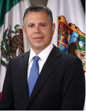
City Mayor: Jesús Antonio Nader Nasrallah
Contact number: +52 (833) 305 2700
Govt. Office Address: Cristóbal Colón S/N, Zona Centro, 89000 Tampico, Tamps.
Twitter: https://twitter.com/gobmuntampico
FB: https://www.facebook.com/GobiernoMunicipalDeTampicoTam
Website: https://tampico.gob.mx
