San Miguel de Allende, Guanajuato 作者: 来源: 发布时间:2021-07-22
1.Basic data
Pop: 139,297 (munip.)
Area: 1,537.19 km2
Elev: 1900 masl
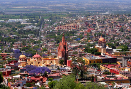
2. Natural geography
The municipality extends over two of the state's natural regions: the Sierras Volcanicas and the Cuencas Lacustres del Sur, with most of the territory over the latter. The entire municipality belongs to the national Trans-Mexican Volcanic Belt. Most of the territory inclines gently from between zero and five percent grade, with some exceptions where inclines can be as high as 25%. This restricts urban development and agriculture in the area. Prominent elevations include Cerro La Silleta, Cerro Prieto, Cerro La Piena, Cerro La Campana, El Cerro de El Picacho, Tambula, El Maguey, Palo Colorado, Mesa el Peñón, Loma Cuacuato, Mesa la Junta, Loma La Trinidad, Cerro El Común, La Loma, El Cuache and El Carmen. These peaks have an average altitude of 2,200 metres (7,200 ft).
The main river in the area is the Laja, which crosses from north to south before finally emptying in the Lerma River in the municipality of Salamanca. The river currently has serious pollution issues because it is used for discharge of wastewater without prior treatment. Most of this discharge is from the residential areas of San Miguel and Dolores Hidalgo. In addition to the river, there are four principal arroyos that pass by the municipal seat: the La Cañadita, El Atascadero, Las Cachinches and El Obraje. The last receives most of the area's runoff during the rainy season and feeds the Las Colonias and El Obraje dams. The most important dam in the area is the Ignacio Allende dam, located in the west of the municipality. While this dam controls flooding along the Laja River, local residents say that the water collected in its reservoir goes to the area around Guadalajara, far to the west of San Miguel, due to the provisions of the federal act creating the dam and reservoir. Other dams in the area include La Cantera and Bordo Grande located in the south and north of the municipality, respectively, along with the aforementioned Las Colonias and El Obraje, which are mostly used for irrigation. The municipality also has fresh water, thermal and alkaline springs, many of which are used as ecotourist attractions, such as the El Chorro, Montecillo, El Cortijo, Cieneguita, Atotonilco and Taboada spas. One other spa is the El Xoté, which has sulfur-laden waters.
Weather
Köppen Classification: Mid-Latitude Steppe and Desert Climate
This climate type is characterized by extremely variable temperature conditions, with annual means decreasing and annual ranges increasing poleward, and relatively little precipitation. This climate is typically located deep within the interiors of continents and is contiguous with the tropical desert climates of North and South America and of central Asia. This region type owes its origins to locations deep within continental interiors, far from the windward coasts and sources of moist, maritime air. Remoteness from sources of water vapor is enhanced in some regions by mountain barriers upwind.
The Köppen Climate Classification subtype for this climate is "Bsh". (Mid-Latitude Steppe and Desert Climate).
The average temperature for the year in San Miguel de Allende is 65.8°F (18.8°C). The warmest month, on average, is May with an average temperature of 72.0°F (22.2°C). The coolest month on average is January, with an average temperature of 58.1°F (14.5°C).
The highest recorded temperature in San Miguel de Allende is 103.3°F (39.6°C), which was recorded in May. The lowest recorded temperature in San Miguel de Allende is 17.6°F (-8°C), which was recorded in February.
The average amount of precipitation for the year in San Miguel de Allende is 22.2" (563.9 mm). The month with the most precipitation on average is July with 4.9" (124.5 mm) of precipitation. The month with the least precipitation on average is March with an average of 0.2" (5.1 mm). In terms of liquid precipitation, there are an average of 57.6 days of rain, with the most rain occurring in July with 11.4 days of rain, and the least rain occurring in March with 0.9 days of rain.
https://www.weatherbase.com/weather/weather-summary.php3?s=911093&cityname=San+Miguel+de+Allende%2C+Guanajuato%2C+Mexico&units=
Getting there and around
Get there
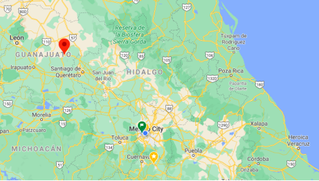
By Air – There is no airport at San Miguel de Allende, but if you want to fly close, you have two options: Aeropuerto Internacional del Bajio near Leon (95 miles) and Aeropuerto Internacional de Queretaro (53 miles)—note that both airports are virtually equidistant from San Miguel in travel time: taking around 90 minutes to reach by car. Check carriers that fly to each location. Mexico City’s international airport, which is about 170 miles away, takes approximately 3.5 hours to get to by car (subject to traffic congestion in and around the capital). Private ground transport to San Miguel from airports is via private taxi or airport transfers.
By Bus – You can travel to San Miguel on a luxury bus from Mexico City – the trip takes around 4 hours and departs from Mexico City’s northern bus terminal. If you don’t want to travel across Mexico City from the airport to the bus terminal, you can board a bus from Mexico City’s airport to Queretaro, where you can can change and board a second bus to San Miguel.
By Car – Driving to San Miguel is very fast and efficient with the roads and toll roads that connect the region.
Car Rental – To explore Mexico’s colonial towns and cities, consider renting a car for your visit. Having your own car will give you more flexibility than using public transport options and, in some cases, offer you access to places which are otherwise difficult to visit without the use of a car.
Get around
Taxis – Taxis in most of Mexico’s colonial towns and cities are not metered, so agree your price before you get in. Taxi travel is very affordable in Mexico, in comparison to the USA, Canada and Europe, and so provides a viable means of public transportation in Mexico. Your hotel can arrange taxis for you; some post their rates on a board in the lobby; taxi hotel rates are usually higher than cabs you hail off the street. If you speak Spanish, you will have a distinct advantage and be able to negotiate a price with the driver.
In the center of the city it is common to walk to avoid traffic and finding parking spaces.
Uber is expanding rapidly across Mexico and now offers services in cities across the country, including: Mexico City, Toluca, Cuernavaca, Puebla, Querétaro, León, Aguascalientes, San Luis Potosí, Guadalajara, Monterrey, Hermosillo, Tijuana, Mexicali, and Mérida. Uber has been adding Mexican cities to its network every year, check for availability when you arrive at your destination in Mexico.
Cabify is developing also and currently operates in cities including Mexico City, Toluca, Monterrey, Puebla, Querétaro and Tijuana. Check for availability in the city you are visiting.
The services offers people with smartphones a way to book a cab through a mobile app for a pre-agreed price. Fares are comparable with Sitio type cabs (see above), and sometimes trade at a premium to this when local demand increases.
https://www.mexperience.com/transport/taxi-travel-in-mexico/#51
https://www.mexperience.com/travel/colonial/san-miguel-de-allende
3.Economy
GDP: 461 M USD
4. Industry
Tourism and commerce
Much of the municipality's economy is tied to the influx of tourists and foreigners who come to live, mostly retirees. In 2002, 250,000 visitors spent about US$8.4 million at the town's attractions, but those who live here contribute far more to the economy. Most of this is concentrated in the town of San Miguel proper. It accounts for over 36% of the municipality's jobs and most of the municipality's income. Tourism accounts for almost all of the municipality's income from outside. This began in the mid-20th century as a cheap place to live; however, despite recent economic downturns, it no longer is. This has not lessened San Miguel's attraction for foreign visitors and retirees as homes and hotels here are still significantly cheaper than in the US or Europe. Despite not having a casino or an airport and being 640 kilometres (400 mi) from the nearest beach, this small city has been ranked by magazines such as Travel and Leisure and Condé Nast Traveler as a preferred place to live and visit.
Hotel occupancy typically reaches 80% on weekends with about 50% occupancy on weekdays, when rates can be about half. Most visitors are vacationers and about 60% are domestic visitors, interested in the town's history and role in the Mexican War of Independence. Another attraction for visitors are the two main art/cultural institutions of Instituto Allende and Bellas Artes as well as a number of Spanish-language schools. Most domestic visitors come from Mexico's large urban centers like Mexico City, Guadalajara, Monterrey and Querétaro. This growth has spurred the development of newer hotels, resort and vacation home developments, especially on the corridor between San Miguel and Atotonilco. There are 149 hotels, 9 of which are 5-star. The town has just over 9% of all hotel rooms in the state, and this percentage is growing. Another important sector is restaurants. In 2006, the town invested 800,000 pesos to implement an online marketing plan to increase services to potential tourists.
Agriculture
Outside of the town of San Miguel, the economy is more traditional. A bit over half of the land is used for grazing with 37% used for crops. Over 80% of the crops are grown during the rainy season with less than 20% grown on irrigated lands. Forestry is minimal. Agriculture produces 25% of the employment in the municipality. Principal crops include corn, beans, wheat, and alfalfa, which account for 84% of harvests. Another important agricultural activity is fruit orchards. The most important livestock is domestic fowl, especially poultry. The municipality raises over 12% of the state's chickens. Another important product is honey, of which the municipality provides 7.5% of the state's total. Since the 1990s, there have been active reforestation efforts to replace much of what was lost previously to logging.
Industry
Industry is not as well developed here as in other parts of the state although it provides about 33% of the jobs. One important industry is the production of electrical energy. Other industries include metal products, food processing, wood products and mineral processing. The area is known for the crafting of objects from brass and glass. Two notable artisans here are the brothers Marcelino and Abeck Leon Rosa, who produce handmade glass items. They began producing pieces in the courtyard of their home, but today they have a studio with two large workshops and operate a school for glassmakers, which trains about 50 people per year. One of their specialties is Tiffany-style lamps.
Since at least the 1950s, San Miguel de Allende is a backdrop for the production of films and television programs. Both Mexican and foreign productions and advertisements have been filmed there. Projects that have been filmed here include Once Upon a Time in Mexico, a television biopic of the Francisco "Pancho" Villa, and The Mask of Zorro II. A group of entrepreneurs is working to increase the town's reputation as a film location, opening a privately financed studio complex called The Film Colony. Recently, U.S. television series Royal Pains, Top Chef and Million Dollar Listing have filmed episodes in the town.
5. Touristic sites
Colonial Centre
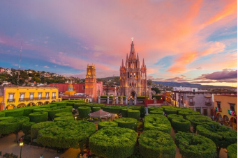
San Miguel is endowed with stunning views and equally stunning colonial architecture. From the minute you enter the town square you’ll be enchanted by its antiquated beauty. The Parish Church, which faces the main plaza (zocalo), is one of the main architectural attractions here.
Be sure to visit the recently restored home (colonial mansion) of Ignacio Allende, the famous Patriot who the town was named after.
Another colonial gem that should be seen is La Casa del Conde Canal (House of the Count of Canal), now occupied by the famous art institute, Instituto Allende (see below). You can walk through the salons and watch as students paint, weave and sculpt as part of their courses.
Instituto Allende
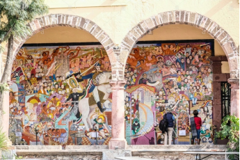
One of the most famous art schools in Mexico, the Instituto Allende hosts thousands of art students from all over the world who come here to learn arts and languages in the heart of San Miguel. Students come here and stay for weeks or months; rented accommodation is plentiful and available in nearby residential areas.
In 1927, the Peruvian diplomat and artist Felipe Cossío del Pomar, while touring Mexico, visited San Miguel de Allende encouraged by the intellectuals Alfonso Reyes and José Vasconcelos, and fell in love with the quality of the light.
More than ten years later, and in pursuit of a dream, he founded the Escuela Universitaria de Bellas Artes in an old convent turned into a barracks.
Towards the end of the 1940s, Cossío del Pomar had the opportunity to travel to his native country, Peru, which filled him with joy. However, his joy would not last long. Upon his return to San Miguel, he found a University School of Fine Arts practically in ruins thanks to the lawyer he had left in charge, so he embarked on a new and ambitious project. With a team of partners that included his former public relations officer, the American Stirling Dickinson, the former governor of Guanajuato, Enrique Fernández Martínez, and Nell Harris, his wife, Cossío founded a new school. Since its creation, the Allende Institute obtained the incorporation to the University of Guanajuato for the Master of Arts and, therefore, the recognition of several universities in the United States. This gave the new school a privileged position and, by 1960, it had grown in both size and scope, offering undergraduate studies as well. Attracted by the possibility of obtaining academic credit for studies carried out in Mexico, an increasing number of North American students found in San Miguel a place to return frequently, sometimes bringing friends with them, thereby further strengthening the economy of the area. The Institute kept pace with a leading visionary at the helm.
http://instituto-allende.edu.mx/acerca-del-instituto
Parroquia de San Miguel Arcangel
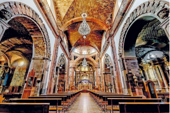
The current parish church of San Miguel is unique in Mexico and the emblem of the town. It is one of the most-photographed churches in Mexico and the two tall towers of its neo-Gothic façade can be seen from most parts of town. The church was built in the 17th century with a traditional Mexican façade. The current Gothic façade was constructed in 1880 by Zeferino Gutierrez, an indigenous bricklayer and self-taught architect. It is said Gutierrez's inspiration came from postcards and lithographs of Gothic churches in Europe; however, the interpretation is his own and more a work of imagination than a faithful reconstruction. In front of this façade is a small atrium, which is guarded by a wrought iron fence. There is a monument in the atrium dedicated to Bishop José María de Jesús Diez de Sollano y Davalos. The San Rafael or Santa Escuela Church is located to the side of the parish. It was founded by Luis Felipe Neri de Alfaro in 1742. The main façade has two levels with arches, pilasters, floral motifs and a frieze on the first level. The second level has a choir window framed by pink sandstone. The bell tower is Moorish. According to legend, this older chapel was the site of the first Christian ceremony in San Miguel.
At the entrance of the main church, there is an inscription which states that Miguel Hidalgo y Costilla and his brother Jose Joaquin served as priests here. There is another one acknowledging Gutierrez's work on the façade. The interior of the church still has the original 17th-century layout and interior design, but the church was looted several times during Mexico's history so much of its decoration is lost. However, one significant image here is the "Señor de la Conquista", which was made of cornstalk paste by indigenous people in Michoacán. The sacristy contains a painting depicting the founding of the town in 1542 and its subsequent move to Izcuinapan in the El Chorro neighborhood. There is a small crypt under the altar with access through a small door to the right. This crypt contains the remains of former bishops of the church and other dignitaries, including a former president of Mexico. It is opened to the public one day each year, on 2 November, Day of the Dead.
Casa de Allende
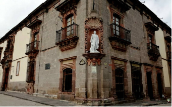
The Casa de Allende (Allende House) museum was the home of Ignacio Allende, who was a principal figure in the early part of the Mexican War of Independence. The structure was built in 1759 with Baroque and Neoclassical elements, located next to the San Miguel parish church. The museum it houses is officially called the Museo Histórico de San Miguel de Allende, and it is one of many "regional museums" of Mexico. This kind of museum focuses on the history of the local area from the prehistoric period to the present, especially the area's role in Mexico's national history. The lower floor contains exhibits about the founding of the town, its role in protecting the Camino Real de Tierra Adentro Road and more. The upper floor contains exhibits related to Ignacio Allende and some of the rooms are preserved as they looked when he lived there. There are 24 rooms that chronicle the history of the area from the foundation of the town to the Ruta de la Plata (English: Silver Route), the genealogy of Ignacio Allende and the Mexican War of Independence. It was remodeled as part of the preparations for Mexico's Bicentennial. The restored museum was re-inaugurated by President Felipe Calderon in 2009.
6. History and Culture
Founding of the city
Before the arrival of the Spanish in the early 16th century, San Miguel was an indigenous Chichimeca village called Izcuinapan. Then a small chapel was built near Izcuinapan by Juan de San Miguel. He decided to dedicate the Spanish town to the Archangel Michael. However, Spanish colonization and attempts to enslave women, men, and children to work the silver mines quickly created a hostile environment with the Chichimeca Confederation natives. The Chichimecas began defending their ancestral lands against invasion by Spanish soldiers and colonizers. In 1551, the Guamare people of the Chichimeca Confederation attacked Spanish military posts and settlements. This overt hostility, along with multiple failed attempts by the Spanish to provide water to their own settlements in the area, caused the original location to be pushed out.
The village was officially re-established in 1555 by Juan de San Miguel's successor, Bernardo Cossin, and indigenous leader Fernando de Tapia. It was refounded both as a mission and as a military outpost. The new site was a mile east of the old one at a place with two fresh water springs (called Batán and Izcuinapan) and with terrain better suited for defense. The two springs supplied all of the town's water until the 1970s.
Colonial period
The House of the Counts of the Canal, built in the 18th century and currently owned by Banamex.
By the mid-16th century, silver had been discovered in Guanajuato and Zacatecas, and a major road between this area and Mexico City passed through San Miguel. Indigenous attacks on caravans continued and San Miguel became an important military and commercial site. This led to the forty-year Chichimeca War. The viceroy in Mexico City granted lands and cattle to a number of Spaniards to motivate them to settle the area. He also gave indigenous groups limited self-rule and excused them from taxation. The location of the town would make it a melting pot as Spanish, indigenous peoples, and later criollos exchanged cultural influences.
Eventually, major roads would connect the town with the mining communities in San Luis Potosí, Zacatecas, and the rest of the state of Guanajuato. Serving travelers' needs and providing supplies to mining camps made the town rich. Textile manufacture was a major industry in the town. Locals claim that the serape was invented here. By the mid-18th century the city was at its height, and this was when most of its large mansions, palaces, and religious buildings were constructed. Most still remain. The town was also home to the area's wealthy hacienda owners. At that time, it was one of the most important and prosperous settlements in New Spain with a population reaching 30,000. By comparison, in the mid-18th century Boston had a population of only 16,000 and New York 25,000. The town's apogee came during the transition period between Baroque and Neoclassical architecture, and many of the mansions and churches show both influences. Mansions built in San Miguel are larger than normal for a settlement of its size.
Independence
The prominence of the city declined at the beginning of the 19th century, mostly due to the Mexican War of Independence. However, it played an important early role in this conflict. It is the birthplace of two significant figures of the war, Juan Aldama and Ignacio Allende. Both were involved in a conspiracy against the colonial government in Mexico City, along with Miguel Hidalgo y Costilla and Josefa Ortiz de Domínguez. When this conspiracy was discovered, the warning to Hidalgo and Allende passed through this town and onto Dolores (Hidalgo), just to the north. This prompted Hidalgo's "Grito de Dolores" assembling the insurgent army on 15 and 16 September 1810. The new insurgent army first came to San Miguel, stopping at a religious sanctuary in Atotonilco just outside. Hidalgo took a standard bearing an image of the Virgin of Guadalupe from here; this standard is now in the Museo del Ejercito in Spain. Then the army entered San Miguel proper, to name officers and to free prisoners in the local jail. San Miguel was the first Mexican town to gain its independence from Spain.
While there was no further military action in the immediate area, economically the town waned as agriculture suffered and the population declined. This continued for most of the rest of the 19th century as the country was torn between Liberal and Conservative factions vying for power. After the war, the town was declared a city by the state congress in 1826 and its name was modified to San Miguel de Allende in honor of Ignacio Allende.
There was some economic recovery near the end of the 19th century during the rule of Porfirio Díaz. During this time, dams, aqueducts and railroads were built. Agriculture made a comeback with the introduction of fruit orchards. However, decline returned with the end of mining in almost all of the state of Guanajuato. Between this and the beginning of the Mexican Revolution, San Miguel almost became a ghost town. What remained was preserved as the new Mexican government, under the Instituto Nacional de Antropología e Historia (INAH), declared San Miguel a "Historic and Protected Town" in 1926, establishing guidelines and restrictions aimed at keeping its colonial appearance. Historian Lisa Pinley Covert denies that such an event occurred in 1926, yet acknowledges that a federal law of 1926 nationalized many Catholic properties in the city, even if historic preservation had not been the motivation.
20th century to the present
American artist and writer Stirling Dickinson arrived in 1937 and should be credited with creating the first wave of advertising abroad about San Miguel's virtues. Dickinson met Peruvian intellectual, author and painter, Felipe Cossio del Pomar who had the idea of establishing an art colony in the heart of Mexico. The first art school was established in 1938 in an old convent—still in use provisionally as a school, after having been soldiers' barracks—which Cossio del Pomar secured from then Mexican president Lázaro Cárdenas. The school was called Bellas Artes, and continues to exist today, locally known as Bellas Artes or Centro Cultural El Nigromante. In the 1940s, Dickinson would also assist Cossio del Pomar and Enrique Fernández Martinez, the former governor of the state of Guanajuato, to establish what became the Instituto Allende. Despite their rural location, both schools would find success after the World War II. U.S. veterans studying under the G.I. Bill were permitted to study abroad, and these schools took advantage of that fact to attract former soldiers as students. Enrollment at the schools rose and this began the town's cultural reputation, this attracted more artists and writers, including José Chávez Morado and David Alfaro Siqueiros, who taught painting at the Escuela de Bellas Artes. This, in turn, spurred the opening of hotels, shops and restaurants to cater to the new visitors and residents. Many of the American veterans who came to study in San Miguel would later come back to retire, some marrying and raising international families such as the Vidargas, Andre, Maxwell, and Breck families.
The town's cultural, foreign and cosmopolitan nature has continued since that time. The city took on a Bohemian quality starting in the 1950s with the party ambiance of many resident expats and artists. In the 1960s, Cantinflas promoted the area among his friends in the film industry. Hippies were taken in for haircuts by the authorities in the 1970s, and now the town is generally too expensive for the backpacking travelers of the 21st century. The growing attraction of the town and its colonial buildings created a vibrant real estate market, which until recently has not been affected by Mexico's fluctuating economy. Many of the old "ruins" of colonial houses have been sold for more than a house in Mexico City.
The city and nearby sanctuary were declared a World Heritage Site by UNESCO in July 2008. It was chosen both for its well-preserved Baroque colonial architecture and layout and for its historic role in the Mexican War of Independence. The area that has been inscribed includes 64 blocks of the historic center and the sanctuary of Atotonilco with the title "Villa Protectora de San Miguel el Grande y el Santuario de Jesus Nazareno de Atotonilco".
7.Contact Information
City Mayor: Luis Alberto Villarreal

Contact number: +52 (415) 152 9600
Govt. Office Address: Blvrd de la Conspiración 130, 37748 San Miguel de Allende, Gto.
Twitter: https://twitter.com/VillarrealGTO
FB: https://www.facebook.com/LuisAlbertoVillarrealG
Website: http://sanmigueldeallende.gob.mx
E-mail: soy@luisalbertovillarreal.mx
