Los Cabos, Baja California Sur 作者: 来源: 发布时间:2021-05-26
1. Population and Area
Pop: 287,671
Area: 3,750.93 km2 (metro)
Elev: 5 masl
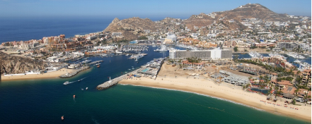
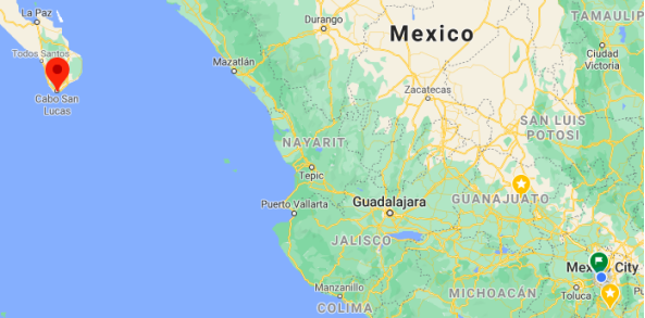
Los Cabos location in Mexico within the State of Baja California Sur
https://goo.gl/maps/btpwiw7SujMj71hKA
2. Natural geography
The municipality of Los Cabos is at the southern end of the Baja California peninsula, where desert meets the sea and the Gulf of California meets the Pacific Ocean. The area was originally underwater, evidenced by the many fossils of marine animals, which are up to 25 million years old. The basement rock underlying Los Cabos formed even earlier, approximately 115 million years ago.
The municipality has an average altitude of forty meters above sea level. There are three main terrain types, mountain terrain, semi flat areas and flat areas. The mountains consist of the Sierra de la Laguna and the Sierra de San Lázaro, both formed of volcanic rock, covering about fifteen percent of the total territory with peaks between 400 and 1000 meters. The semi flat areas are located between the coast and the mountain ranges, mostly of sedimentary rock and account for sixty percent of the territory. The flat areas are along the coast, beaches and alluvial plains, which account for twenty five percent of the territory.
As it is on the edge of the desert that covers most of the Baja California peninsula, it is one of the sunniest locations in the world, with an average of 320 days of sunshine per year. The climate is characterized as hot and dry to the north of the town of San José del Cabo, hot and semi moist in San José and along the southern coast and temperate and dry in the highest elevations, because of cyclones that hit this area. Average annual temperature is 24C with the coolest month being January. There is a rainy season in the summer, with most rain in September. The rain and terrain make for a variety of micro climates, including areas with a climate similar to the Mediterranean. Areas between 0 and 400 meters are desert and semi-desert, with many areas having deep sand deposits. Higher elevations get more water and can have pine forests.
The main surface water of the municipality is the Río San José or San José River, which runs north to south, mostly during the rainy season. Other streams run only during rains and include Santiago, Miraflores, Caduaño and Las Palmas. There are subterranean deposits of water such as the Santiago and San José del Cabo, but the lack of water is the main impediment to human development in the area.
The Río San José stops just shy of the ocean, with a one km long sand bar creating an estuary, the third largest in Mexico. This pooling of brackish water has created an oasis in the surrounding Sarcocaule desert. The Río San José flows largely underground for 40 miles (64 km) from its origin in the Sierra de la Laguna (Laguna Mountains), although its Miramonte River tributary adds almost an additional 10 miles (16 km). Its tributaries flow down the eastern side of the sierra and include Santa Rosa, Santa Lázaro, San Miguel, San Ignacio (at La Palma), Caduaño, Miraflores and San Bernard.
The river used to flow above ground until the beginning of the 20th century due to anthropogenic causes. For more than 250 years the Río San José has furnished drinking and irrigation water for the town of San Jose del Cabo, beginning as a source of fresh water for Spanish galleons traveling back from the Philippines. Over the sand bar from the estuary is a bay referred to by early Spanish explorers, including Sebastian Vizcaino, as the Bahía de San Bernabé or Bay of San Bernabé, and now as the Bay of San José del Cabo.
The estuary is home to both native and migratory birds and aquatic species, 250 species of tropical birds alone. Most of the migratory species use the area as a stopover on their way to southern Mexico, Central American and South America. It also acts as a nursery to many juvenile and larval stage species. It was declared a state environmental reserve, but pollution and excessive water extraction has caused it to degenerate, leading to a complaint by Greenpeace. One effort to improve the water situation is the creation of new water treatment plants in the 2000s.
Vegetation varies mostly by altitude and soil type and how much moisture the area receives. However almost all species are those adapted to desert and semi-desert zones. The highest elevations have pine forests. Wildlife is varied and includes mammals such as badgers, skunks, coyotes, foxes, pumas and other wild cats, deer, raccoons, rabbits, bats and various rodents. Bird species include quail, doves, cardinals, woodpeckers, swallows and marine species such as pelicans and seagulls. There are over 850 species of aquatic animals off the coast such as marlin, sailfish, swordfish, tuna, dorado and whales. Many species and subspecies of both plants and animals are endemic only to Baja California.
Weather
Köppen Classification: Tropical and Subtropical Desert Climate
This climate is dominated in all months by the subtropical anticyclon, or subtropical high, with its descending air, elevated inversions, and clear skies. Such an atmospheric environment inhibits precipitation. Most of Earth's tropical, true desert climates occur between 15° and 30° latitude. The most extreme arid areas also are far removed from sources of moisture-bearing winds in the interiors of continents and are best developed on the western sides of continents, where the subtropical anticyclone shows its most intense development. An exception to the general tendency for aridity to be associated with subsidence is in the Horn of Africa region, where the dryness of Somalia is caused more by the orientation of the landmass in relation to the atmospheric circulation. Both the high- and low-sun monsoonal winds blow parallel to the coast, so that moisture-laden maritime air can penetrate over land only infrequently.
The Köppen Climate Classification subtype for this climate is "Bwh". (Tropical and Subtropical Desert Climate).
The average temperature for the year in Cabo San Lucas is 73.0°F (22.8°C). The warmest month, on average, is July with an average temperature of 82.0°F (27.8°C). The coolest month on average is January, with an average temperature of 66.0°F (18.9°C).
The highest recorded temperature in Cabo San Lucas is 111.2°F (44°C), which was recorded in September. The lowest recorded temperature in Cabo San Lucas is 33.8°F (1°C), which was recorded in March.
The average amount of precipitation for the year in Cabo San Lucas is 7.9" (200.7 mm). The month with the most precipitation on average is September with 2.7" (68.6 mm) of precipitation. The month with the least precipitation on average is May with an average of 0.0" (0 mm). In terms of liquid precipitation, there are an average of 12.8 days of rain, with the most rain occurring in September with 3.4 days of rain, and the least rain occurring in May with 0.0 days of rain.
From top to down: highest, average high, average, average low, lowest.
https://www.weatherbase.com/weather/weather-summary.php3?s=764051&cityname=Cabo+San+Lucas%2C+Baja+California+Sur%2C+Mexico&units=&set=metric
Getting there and around
Get there
By Air – You can get to Cabo San Lucas by plane from Mexico City, Guadalajara, Tijuana, and various places in the USA, especially Los Angeles, CA. The same airport that serves Cabo San Lucas serves San Jose del Cabo, although it is closer to San Jose del Cabo. Taxis and vans are available from the airport; to save time and secure your space, consider pre-booking a shuttle so that someone is there to meet you at the airport when you arrive (see Airport Transfers, below).
By Ferry – If you are on Mexico’s mainland, or want to get to it, there is a ferry that crosses the Sea of Cortez (also known as the Gulf of California) to and from La Paz to the port cities of Mazatlan and Los Mochis (Topolobambo). The ferry trip to/from Mazatlan takes 18 hours and does not run daily; sleeping cabins are available with advance bookings. The ferry to/from Los Mochis (Topolobambo) takes around 8 hours and does not sail daily either. Check the Ferry’s web site at: http://www.ferrytmc.com for details of routes, schedules, prices and contact details. Note: from 2004, a new Catamaran ferry is being operated, and this has significantly reduced the travel times across the Sea of Cortez from Mexico’s mainland to La Paz.
By Bus – To get to Baja California Sur, your best bet is to fly there (see above); the bus journey from Tijuana to La Paz is about 27 hours; then a further 2 hours from there to Los Cabos.
By Car – Driving to Cabo San Lucas from the southern border of the United States will take you about twenty to twenty-four hours on Highway 1 and then a further two hours on Highway 19.
Car Rental – To explore Mexico’s provincial towns and cities—including its beach locations and the scenery and attractions near them— consider renting a car for your visit. Having your own car will give you more flexibility than using public transport options and, in some cases, offer you access to places which are otherwise difficult to visit without the use of a car.
Get around
Local Buses – Local buses and mini-buses (combis or micros) are available locally for a fraction of the cost of a taxi around town. You need to speak Spanish to be able to ask for directions or ask the driver to tell you where to get off.
Taxis – Taxis in most of Mexico’s towns and cities are not metered, so agree your price before you get in. Taxi travel is very affordable in Mexico, in comparison to the USA, Canada and Europe, and so provides a viable means of public transportation in Mexico. Your hotel can arrange taxis for you; some post their rates on a board in the lobby; taxi hotel rates are usually higher than cabs you hail off the street. If you speak Spanish, you will have a distinct advantage and be able to negotiate a price with the driver.
Uber is expanding rapidly across Mexico and now offers services in cities across the country, including: Mexico City, Toluca, Cuernavaca, Puebla, Querétaro, León, Aguascalientes, San Luis Potosí, Guadalajara, Monterrey, Hermosillo, Tijuana, Mexicali, and Mérida. Uber has been adding Mexican cities to its network every year, check for availability when you arrive at your destination in Mexico.
Cabify is developing also and currently operates in cities including Mexico City, Toluca, Monterrey, Puebla, Querétaro and Tijuana. Check for availability in the city you are visiting.
The services offers people with smartphones a way to book a cab through a mobile app for a pre-agreed price. Fares are comparable with Sitio type cabs (see above), and sometimes trade at a premium to this when local demand increases.
https://www.mexperience.com/transport/taxi-travel-in-mexico/#51
https://www.mexperience.com/travel/beaches/cabo-san-lucas
3.GDP
GDP: 22.4 M MXN
4. Industry
By far the main economic activity for the municipality is tourism, focused on a shoreline corridor between Cabo San Lucas and San Jose del Cabo. Most visitors come from the United States (especially California) and Canada, followed by Mexico, and many visitors return year after year. Visitors can get by in Cabo San Lucas purely in English and use U.S. dollars.
Most of the about two million visitors a year arrive by plane to the Los Cabos airport, but the Cabo San Lucas marina also has facilities for cruise ships. In 2012, the area has hotel occupancy of just over 60% with 248 cruise ships visiting. The area's high-end resorts have also attracted notable names such as Bruce Willis, Kelly Preston and John Travolta, and San Jose del Cabo also has a notable expatriate population, mostly retirees who have economic influence.
The main draw for most visitors has been the environment, where the desert meets the sea, best symbolized by El Arco, a natural stone arch over the ocean in Cabo San Lucas where the Pacific Ocean and the Gulf of California meet. The natural features have led to ecotourism such as boat tours to El Arco, tours of the San Jose Estuary and the coral reefs of Cabo Pulmo, and whale watching from January to March, when the animals are here to breed.
The main export of the municipality is the production of salt. There are also limited mineral deposits, especially in the Capuano and Mezquite areas such as limestone and granite.
The small town of Miraflores is known for its leatherwork, especially saddles and other gear for horseback riding. Jewelry and decorations made with shells are produced in San José del Cabo, Cabo San Lucas and Santa Rosa.
Despite the development, 28.5% live in poverty and 5.6% live in extreme poverty; 18.1% live in substandard housing and 27.1% need food assistance. There are 313 schools from the primary to high school level. 9.3 years of schooling for those over 15. There are two vocational schools and twelve centers for adult education. There are no schools specifically targeting an indigenous population.
5. Touristic sites
Los Cabos beaches
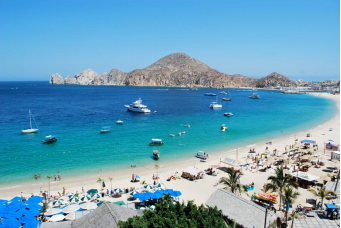
Cabo San Lucas has a great ‘principal’ beach – called Medano. You can rent snorkeling equipment and non-motorized water equipment right on the beach. This is a good place to sunbathe and swim as well.
Farther out of town, you can find some remote beaches along the shoreline between “the two cabos” (Cabo San Lucas and San Jose del Cabo). These include the Barco Varado, Chileno, Palmilla, Santa Maria and Vista del Arco Beaches, for those who want to get away from the crowds and see some stunning beaches and shoreline.
Whale Watching
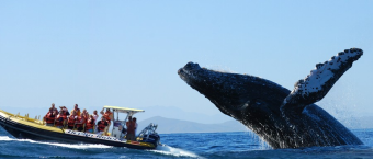
From the Bering Strait, whales migrate to the Pacific coast of Baja California Sur between January and March of each year. To see the marvel of these great creatures, you’ll need to visit in season. There are three main areas where it’s best to view the whales – the main one being Magdalena Bay off the Pacific coast.
Typically we see adult Humpback Whales transiting through Cabo San Lucas from mid November until early December. ... The other species that migrates into Cabo San Lucas is the Gray Whale. Typically arriving in early January the adult Gray Whales we see are often in small groups and seen in Cabo until late March.
https://whalewatchcabo.com/whale-watching-cabo-best-time
Ecotourism
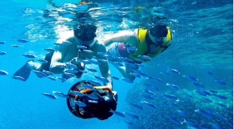
Los Cabos is a perfect base from which to enjoy Mexico’s great outdoors and take part in a variety of nature and adventure experiences in Mexico.
The local ecology, the landscape, the climate and the proximity to the sea make this region a paradise for those who love nature. What’s more, you can find experienced and well prepared organizations in Los Cabos who are ready to help you enjoy the best of what this region offers.
Fishing, kayaking, sailing, camping, surfing, horseback riding, nature walks, fabulous bird watching, cliff hikes, sunset cruises and watching the amazing whales and sea lions are just some of the activities you can enjoy in the area.
Local Cruises
There’s no better way to enjoy the scenery in this area than on a local boat cruise. Local cruises take you on tours around the many islets surrounding Baja California Sur, and include sunset cruises that let you experience some of the most wonderful sunsets you’ll view in your life.
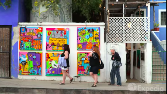
Los Cabos Vacation Travel Guide | Expedia
https://youtu.be/nJNLnBCQMy0
6. History and Culture
The indigenous Pericu names for San Jose del Cabo and Cabo San Lucas were Añiñi and Yenecami, respectively, with the current names given by the colonizing Spanish. The name of San José was given by Nicolás Tamaral in honor of José de la Fuente Peña y Castrejón, the Marquis of Villa Puente who sponsored the mission. The appendix of “de Los Cabos” is to distinguish it from San José de Comondú as well as its proximity to Cabo San Lucas. San Jose was also known as San Barnabé, as the nearby bay was named this. Pirate Thomas Cavendish called Cabo San Lucas “Safe Port” as he hid there from Spanish authorities. The seal for the municipality of Los Cabos (referring to the two cities) was approved by the state government in 1981.
When the Spanish arrived the main indigenous group in the area was the Pericus, a hunter-gather culture with Stone Age tools. It is possible that these people arrived to the region with a more evolved culture which later simplified to adapt to the harsh conditions. Evidence of this includes the region's cave paintings as the peoples found by the Jesuits did not have an artistic tradition. The Pericu people and culture were distinct from other indigenous groups, first by being taller and second by being polygamous in a tribal organization. Their diet consisted of local seeds and fruits, as well as fish, reptiles, and small mammals. Men were in charge of large game hunting of deer.
Hernán Cortés himself arrived here in 1535, and named the Gulf of California the Sea of Cortés (Mar de Cortés) the name still used for it in Spanish. The harsh conditions impeded colonization by the Spanish, which did not begin in earnest until 1730, when Father José Echeverría and Father Nicolás Tamaral founded a mission in what is now San Jose del Cabo in 1730. This date is considered the founding of the town, although a second ceremonial found took place in 1822, when it was declared a town of the Baja California territory.
Diseases brought by Europeans devastated indigenous groups here, and in 1768 more missionaries arrived. While colonization was slow, the area was important as a way station for the Manila Galleon and other ships, which stopped here for fresh water, as well as fruits and vegetables.
However, its remoteness also made it a place for pirates to hide. The first pirate in the area was Francis Drake in 1578, followed shortly after by Thomas Cavendish, both after the treasures from Spain's Asia trade. One major attack was that on the Santa Ana Galleon, whose looting caused the Spanish colonial government to explore and map the area around Cabo San Lucas at the very beginning of the 17th century. There were recommendations to establish a mission here, but this was rejected in favor of Loreto. This left Cabo San Lucas as a strategic hideout for English pirates until the 18th century. In 1709, pirate Woodes Rogers attacked the Nuestra Señora de la Encarnación y Desengaño. Hiding nearly a month in Cabo San Lucas, he also mapped the area and wrote detailed descriptions. He was followed by George Shelvocke in 1721, who later published the oldest known drawings of the Pericues.
After Independence, the Baja Peninsula was part of the California province, but Cabo San Lucas was named head of a municipality. Its remoteness kept the area out of active participation of most of Mexico's 19th and early 20th century tumultuous history. One exception was the Mexican American War. Resistance to U.S. forces was organized in the small community of Santa Anita, near San José, headed by José Matías Moreno, Vicente Mejia and José Antonio Mijares, who was in charge of the marina at Cabo San Lucas. One of the main streets in the town is now named after Mijares, who died defending the town.
The major political players during the Mexican Revolution were Manuel Gonzalez and Pedro Orozco, along with Félix Ortega. In 1915, Ildefonso Green Ceseña, head of forces loyal to Venustiano Carranza, drove out those of Francisco Villa out of the southern part of the peninsula.
Some development of the area began after the Mexican Revolution with a lighthouse at Cabo Falso as early as 1905, just southwest of Cabo San Lucas, in part to remind U.S. ships in the waters here that the territory remained Mexican. Today, it is known as the “Faro Viejo” (Old Lighthouse) and is a historic monument. In 1917, a U.S. company began tuna fishing operations here and had a floating processing plant. In 1927, the Compañía de Productos Marinas based its operations in Cabo San Lucas and helped develop the port to make it open to tourism later. In the 1920s, the first road connecting San José del Cabo and Cabo San Lucas was begun but not completely finished until 1970.
For the most part, the area remained rural and undeveloped until the latter 20th century, when the federal agency Fonatur began to develop a tourism industry here.[8] Development began with Cabo San Lucas for vacationers, but then spread to San Jose del Cabo, but with a different direction with more art galleries and promotion of its traditional Mexican character.
The current municipality of Los Cabos was created in 1981, separated from the municipality of La Paz, with the seat at San Jose del Cabo. The town had previously been a municipal seat of a municipality of the same name in 1917 but lost this in a political reorganization in 1972
7. Contact Information
City Mayor: Armida Castro Guzmán
Contact number: +52 (624) 14 67 600
Govt. Office Address: Blvd. Mijares N° 1413, E/Calle Zaragoza y Manuel Doblado. Col. Centro
FB: https://www.facebook.com/armidacastroguzman
Twitter: https://twitter.com/jArmidaCastro
Website: https://www.loscabos.gob.mx
