Colima city, Colima 作者: 来源: 发布时间:2021-03-22
1. Basic data
Population: 150,673 (2010, city)
Área: 1668.2 km²
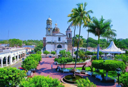
Colima City location
Source: https://www.freecountrymaps.com/map/towns/mexico/273592234/
2. Natural geography
Most of the municipality is located in the Valley of Colima. About half of the municipality has rugged, mountainous terrain, most of which is on the south and southeastern sides but with an average altitude of only 550 masl. These areas are part of the areas belonging to the Colima Volcano and a set of mountains called the Cordillera Costera del Sur, which is part of the Sierra Madre del Sur, especially that of the north and northwest to the Cerro de los Gallos mesa. These mountains separate the area from the ocean.
Weather
The climate is semi-humid with rains in the summer, with an annual average temperature of between 24 and 26 °C. One exception to this is a section near the Cuauhtémoc border where the temperature is between 22 and 24° C and annual rainfall is between 1,000 to 1,300 mm (39.4 to 51.2 in) as opposed to the 800 to 1,000 mm (31.5 to 39.4 in) average for the rest of the municipality. Another exception are the communities of Estampilla and Las Tunas, where the climate is drier and hotter, with an average temperature of 26 to 28 °C (79 to 82 °F) and an annual precipitation of between 600 to 700 mm (23.6 to 27.6 in).
In the center, west and southeast, the dominant type of natural vegetation is low growth rainforest. About seventy-five percent of these trees shed their leaves during the dry season. The southeast also contains areas with medium-growth rainforest, which also is deciduous. Most of this forest is near the Ixtlahuacán border. In the highest elevations, south and southeast of the Tepames community, there are some localized forests of holm oak.
Getting there and around
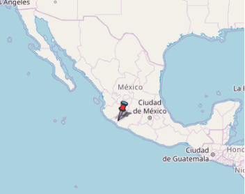
You can get to Colima by plane from Mexico City by AeroMar or from Tijuana by Volaris. The Airport is located 15km north, outside the city. To get to the downtown your only option is a taxi, which will cost $20.00 USD.
Most international visitors to Colima generally fly to Guadalara. Guadalajara, Mexico's second largest city, offers a variety of options to chose from. Once arriving at the airport, at the terminal entrance/exit doors, one can find a couple of stands that sell taxi tickets. One can buy a ticket to any location in Guadalajara for about 20-30 dollars. Persons chosing to travel to Colima should buy a ticket at the taxi stand. The cost is generally about 20 dollars to the bus station. The bus terminal has several modules so be careful to know the bus company on which you will travel. The taxi driver will then know at which of the terminals to drop you off. The most common bus lines are "Línea Plus," which by far has the most departures, leaving almost every hour. Another important bus line is "Primera Plus," which also offers many departures or "Omnibus de México." If you want to splurg, the ETN bus company also offers luxury class, which has extra large seating, similar to first class airline seats, but it cost about 30% more. Please note that the "Omnibus de México" bus line stops at an intermediate city (Ciudad Guzmán) and takes about 40 minutes longer to arrive. The traveling time from Guadalajara to Colima is about 3 hours and the buses are first class, meaning that they serve a softdrink and sandwich, have airconditioning, comfortable seating, clean bathroom(s) and television or music, depending on the specific bus.
Once arriving at the Colima bus terminal, the local cabs will charge no more than 2.50 dollars to take you to any location in Colima or the adjoining city of Villa de Álvarez. There is a taxi booth at the entrance/exit of the Colima bus station where you can buy your ticket.
Taxis are the easiest way to get around the city and they an affordable and convenient option. You can always ask the front lobby of your hotel for assistance getting a taxi or use a "sitio", which are taxi-bases found all around town. Hailing a taxi from the street is also very common and reasonably safe in this city.
Additionally, the city of Colima has a bus system that is mainly used by locals due to its intricate routing system around town. The cheap price of taxis, however, should outweigh the need to use public buses.
If you are staying in the down-town district of Colima, you should be able to get around mostly by foot, as there are many attractions available at short walking distance. Consult with the concierge or front-desk person of your hotel for general advise and recommendations on the area where you are staying.
If you plan to visit some of the many attractions on the outskirts of the city, you may want to consider renting a vehicle, altough hiring a taxi is very cheap for trips within the city, the cost can rise considerably once you hit the road.
Source: https://wikitravel.org/en/Colima#Get_around
3. Economy
Based on GDP/capita and population in 2010, the GDP estimate for that year, for the municipality of Colima, is 16,576,647.36 MXN.
4. Industry
The city of Colima is the economic center of the state. It is one of seventy-one urban areas and 308 municipalities that contribute over eighty percent of Mexico's GDP. It is ranked twelfth in competitiveness. Its main competitive advantage is reliable and objective local laws with its weakness being sustainable use of the local environment. The working population of the municipality is 51,509, with 3,145 working in agriculture, 10,820 in industry, mining and construction and 35,809 in commerce and services as of 2009. A study by the University of Colima concluded that the municipality is the most competitive in the state and one of the most competitive in the center west of Mexico. Two economic advantages the municipality has are its well development commerce and services sector and its low rate of unemployment. One main disadvantage is its lack of developed technology sector, with most businesses dedicated to basic commodities. Others include high bureaucratic costs, crime rate, over exploitation of aquifers and problems with waste management, especially hazardous materials.
Agriculture is exclusively practiced outside of the city proper, by the small rural communities which still depend on it economically, along with some mining and fishing. The municipality has a total of 70,000 hectares dedicated to agricultural production, which is over ten percent of the total. Most soils in the municipality are fertile. Most irrigated agriculture occurs in the west of the municipality on the Los Asmoles, Las Golondrinas and Los Ortinces mesas. Main crops include corn, rice, melons, animal feed, sugar cane and limes. Other important crops include sorghum, tomatoes, tomatillos, beans, peanuts, mangos, tamarind, coconut, papaya, agave and bananas. Livestock mostly consists of domestic fowl followed by cattle, horses, sheep, goats and pigs. Agriculture employs just over nine percent of the population.
Except for some limestone at the Cerro de Galindo, there are no exploitable minerals in the municipality. Industry is limited to food processing and packaging, especially of rice. There is also some production of oils, soaps and sweets. This sector of the economy employs just over twenty percent of the population.
About sixty eight percent of the population is employed in commerce and services.[5] Colima is one of the state's main commercial centers and is the major distribution center for goods destined for local consumption. The municipality has five traditional fixed markets, eight department stores, ten tianguis markets, one flea market and a very large number of small, independent retail stores. The main economic activities in the city are commerce and services, including tourism. However, the city lacks major cultural and heritage sites, with makes it lag behind Manzanillo and the small town of Comala as a tourist attraction.
Colima’s Municipal Government Flagship Projects
1.- Monitoring and prediction of floods in real time through mobile phone networks and Wi-Fi
This project is in the execution phase and it is expected that it will be ready in less than four years.
According to its description, it consists of the establishment of a real-time flood monitoring and alert system along the Colima River, the Pereira Stream and the Manrique Stream, with the objective of detecting the water conditions in the channels before and during flood events.
2.- A monitoring and communication of risks associated with atmospheric events
According to the document, this plan is being planned and it is expected to be implemented in the medium term.
At this point, it is proposed to model and forecast the development of atmospheric phenomena, monitor them in real time and communicate it by various means to "groups or communities, such as young people and older adults."
3.- Establish a body for the promotion and development of the downtown area
The project is contemplated in the medium term and, according to the document, it is still a proposed idea that has been endorsed by “city actors”.
It provides for the creation of a municipal decentralized public body in charge of directing, executing, controlling and evaluating strategic actions of a governmental and citizen nature that contribute to the urban, economic, social and environmental revitalization of the downtown area of the city. This would have a technical-political council made up of representatives of unions, companies, neighbors and organizations linked to the downtown area of the city, and would report its results to the Colima City Council.
4.- Create a trust for strategic projects
The trust is just an initiative that has been proposed and it would be contemplated to implement it in the medium term.
Through this mechanism, the strategy indicates, it is intended to make it possible to explore private participation for the financing of initiatives or for the establishment of sponsorship or advertising schemes that guarantee the financial viability of municipal projects.
5.- Articulate a network of municipal public markets
This is also in the initiative phase and is contemplated in the medium term.
The action seeks the rehabilitation, equipping and improvement of the facilities of the Francisco Villa, Constitución and Álvaro Obregón markets, as well as the involvement of municipal flea markets, both urban and rural.
6.- Create a Metropolitan Institute of Planning and Resilience
The plan is a medium-term initiative with which it is contemplated to create a public inter-municipal management body with the task of carrying out metropolitan planning and unifying the growth visions of the five municipalities that make up the Metropolitan Area (Colima, Comala, Coquimatlán, Cuauhtémoc and Villa de Álvarez).
7.- Design an urban development program for the Colima-Villa de Álvarez conurbation
This is a long-term initiative and consists of a planning instrument that would examine the provisions, urban reserves and general policies for the occupation of space in the municipal seats of Colima and Villa de Álvarez. The project seeks to balance the processes of regeneration, optimization and control of the territory.
8.- An integrated regional transport system
This consists of the integration of the public transport modes of the state of Colima from a single entity that would manage the operation, infrastructure, image, information, rate and quality of service. It is a long-term project that is just in the initiative phase.
9.- Community separation of urban solid waste
It is expected in the short term and it is already in planning to establish a series of collection points for urban solid waste in parks, gardens or sports spaces so that neighbors can separate their garbage, in particular plastic, aluminum, glass, paper, cardboard and used vegetable oil.
10.- Inclusion of resilience and climate change criteria in environmental management instruments
It seeks to implement this idea in less than four years in collaboration with the Institute of the Environment for Sustainable Development of the State of Colima (IMADES), to analyze the current environmental management mechanisms in terms of environmental impact and ecological territorial ordering for, to from there, generate modifications.
11.- A model of civic justice, attention to victims and proximity police
This point is already being carried out in the municipality, but it is contemplated that it will be fully developed in the medium term. Said model aims to strategically strengthen the operations of the General Directorate of Public Safety and Highway Police in terms of attention, processing and monitoring of minor offenses and conflicts of citizen coexistence.
Source: https://estacionpacifico.com/2019/04/19/11-proyectos-que-se-busca-que-sean-el-legado-de-resiliencia-de-la-ciudad-de-colima/
5. Touristic sites
Cathedral Basilica de Colima
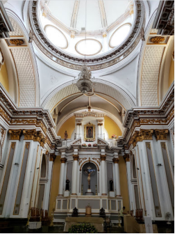
The Cathedral Basilica of Our Lady of Guadalupe[1] (Spanish: Catedral Basílica de Nuestra Señora de Guadalupe) Also Colima Cathedral[2] Is the name that receives the most important Catholic church of the city of Colima, in Mexico[3] that was designated 12 of October 1998 by Pope John Paul II, like Basilica Minor, since it is the first consecrated to the Virgin of Guadalupe in Latin America. Located in one of the corners of the Libertad Garden, in the center of the city of Colima.
Raised in the same place that the Spaniards assigned for the parish and the royal houses of the city. Its origin goes back to the year 1525 during the colonial era. Built of adobe, ornaments of gold, brick and stone endured this inclement weather and trembling being the oldest cathedral in Mexico and North America, It was completed in 1540.
María Teresa Pomar Museum
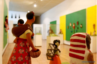
Museo Universitario de Artes Populares María Teresa Pomar is a museum dedicated to Mexico's handcrafts and folk art tradition, called “artesanía.” It is part of the University of Colima in the city of Colima, founded by artesanía collector and promoter María Terea Pomar. It contains one of the most important collections of its type in Mexico, covering traditions from around the country as well as the artesanía and traditions of the state of Colima.
The institution hosts an important permanent collection of Mexican handcrafts and folk art, called artesanía, with the major branches of this tradition from all regions of the country represented. Notable artisans with works on display here include Guillermo Ríos, Emilio Pinto, Pancho Muñoz and the Terríquez and Morfín families. The museum also promotes the artesanía and regional traditions of the state of Colima. The handcrafts of Colima were shaped by Spanish colonialism and by the crafts of other regions of Mexico such as the Talavera pottery tradition of Puebla and the barro negro pottery tradition of Oaxaca. For this reason, a wide variety of handcrafts are produced in the state.
Services that the museum offers include a library with books and video related to handcrafts and the traditions of Colima. There are educational programs, guided tours and a workshop to make bruñido pottery. There is a gift shop. The museum has sponsored events to promote local artisans and works with the university providing cultural activities in which students can participate for credit. This includes participating in workshops such as those for producing ceramics, given by Guillermo Ríos.
Colima Volcano
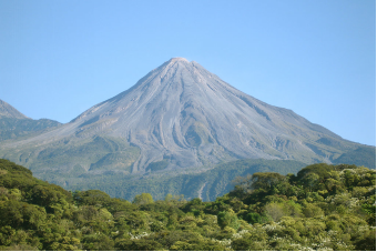
The Volcán de Colima, 3,820 m (12,533 ft), also known as Volcán de Fuego, is part of the Colima Volcanic Complex (CVC) consisting of Volcán de Colima, Nevado de Colima and the eroded El Cántaro (listed as extinct). It is the youngest of the three and as of 2015 is one of the most active volcanos in Mexico and in North America. It has erupted more than 40 times since 1576. One of the largest eruptions was on January 20–24, 1913.[4] Nevado de Colima, also known as Tzapotépetl, lies 5 kilometres (3.1 mi) north of its more active neighbor and is the taller of the two at 4,271 meters (14,015 ft). It is the 26th-most prominent peak in North America.
Despite its name, only a fraction of the volcano's surface area is in the state of Colima; the majority of its surface area lies over the border in the neighboring state of Jalisco, toward the western end of the Trans-Mexican Volcanic Belt. It is about 485 km (301 mi) west of Mexico City and 125 km (78 mi) south of Guadalajara, Jalisco.
In the late Pleistocene era, a huge landslide occurred at the mountain, with approximately 25 km³ (6 cubic miles) of debris traveling some 120 km, reaching the Pacific Ocean. An area of some 2,200 km² was covered in landslide deposits. The currently active cone is within a large caldera that was probably formed by a combination of landslides and large eruptions. The lava is andesite containing 56-61% SiO2. About 300,000 people live within 40 km (25 miles) of the volcano, which makes it the most dangerous volcano in Mexico. In light of its history of large eruptions and situation in a densely populated area, it was designated a Decade Volcano, singling it out for study.
La Campana
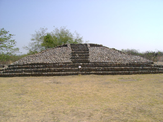
La Campana is an archaeological site included in the Mexican archaeological heritage list since 1917. Located in the vicinity of the city of Colima. This site was the largest prehispanic population center in western Mexico. Site studies indicate that some of its features are related to the classical period Teotihuacan culture.
Vestiges of Capacha phase ceramics, dating from the year 1500 BCE were found onsite. This site features the presence of shaft tombs, ceramics offerings, storm drain systems, avenues and an administrative and religious center with numerous monuments. The site was opened to the public in 1995. The Spaniards discovered the place in 1524, at the time it was known as Almoloyan or “place between two rivers”.
During prehispanic times, the region of the Colima state was seat of various ethnic groups which flourished in western Mexico. The region was inhabited by various Lordships (not reigns as erroneously stated by some historians) that disputed the territories. At the beginning of the 16th century, Purépecha groups dominated several regions, the Tzacoalco salt mines owned by Tecos, because of this their leader Coliman or Tlatoani Colimotl defeated them, after the salt war, the Tecos took Sayula, Zapotlán and Amula and even reached Mazamitla, becoming the predominant group.
Mexico from the Sky: Colima
https://www.youtube.com/watch?v=HADPQ6PZEgU
6. History and Culture
Colonial period
The Spanish colonial settlement of Colima was founded on 15 July 1523 at a location now known as Caxitlán, near present-day Tecomán. This settlement was founded by Gonzalo de Sandoval under orders from Hernán Cortés in order to control the newly conquered Central Mexico region. Due to disease, the settlement was moved on 20 January 1527 to the current location with the name of Villa de San Sebastián Colima. It was the eighth settlement founded by the Spanish in the Viceroyalty of New Spain. Hernán Cortés visited the settlement in 1535.
19th Century
Miguel Hidalgo y Costilla was in charge of the parish of Colima in 1792. This would lead to a friendship with Father José Antonio Díaz, who would be an insurgent leader in the area during the Mexican War of Independence. The Battle of el Llano de Santa Juana took place on 12 July 1811, with the city taken by the insurgents under Ignacio Sandoval and El Lego Gallaga. Insurgents under José Antonio Torres and Rafael Arteaga arrived to the city, bringing twenty Spanish hostages from Guadalajara. Eleven would be killed but nine were saved by Francisco Ramírez de Oliva. When royalist troops retook the city in March 1811, about three hundred insurgents and sympathizers were executed.
The city under Anastacio Brizuela swore allegiance to the Plan of Iguala in June 1821.[9] When Independence was achieved in 1821, what is now the state of Colima still belonged to the province of Guadalajara.[5] In September 1821, the municipalities of Colima and Zapotlán were ordered to negotiate their borders by the department of Guadalajara. During these negotiations, Zapotlán ceded Tonila to Colima, and Colima ceded Tecaltlán and Xilotlán to Zapotlán.
Colima and the territory it controlled were loyal to Iturbide. However, since it was then part of the territory of Guadalajara, it was forced to support the republic when it was proclaimed in 1823. The city and territory was made part of the state of Jalisco when it was established, with the city remaining the capital of the Colima province. The city tried to gain independence from Jalisco as a new state, but was denied.[9] Anastacio Brizuela continued to work from 1823 to 1824 to separate the city and its province to make it a separate state. This occurred on 4 October 1824, separating from the state of Jalisco. However, this independence was not stable with the area passing back and forth between independent state and province of Jalisco. However, whether state or province, the city remained the seat of government for the area.
In 1824, the town of Colima was recognized as a city. The annual city fair was authorized in 1825 to occur for fifteen days in March.
When part of Jalisco, the city had problems because its political orientation was different from that of Guadalajara. It was also far from where political decisions were made, impeding economic development. This lack of support from Guadalajara kept ambitions for a distinct state alive, with city first petitioning for more support from Guadalajara, but not receiving it.[9] The state and capital were formally recognized in the 1857 Constitution with Manuel Alvarez as the first constitutional governor.
The city hosted the government of Benito Juárez from March to April 1858.
During the French Intervention in Mexico, the state was taken over by those loyal to Maximilian I, reducing the state to an administrative department. Insurgent General Ramón Corona took the city on 31 January 1867 as part of efforts to restore the Mexican Republic.
The Manzanillo-Colima railroad was inaugurated in 1889.
Mexican Revolution to the Present
Francisco I. Madero arrived to the city to campaign in 1909. After civil war broke out, forces loyal to this leader entered the city on 18 May 1911 under Eugenio Aviña. Insurgents under Juan José Ríos took control of the city between 1914 and 1916, beginning a series of social and economic reforms. Venustiano Carranza was in the city in 1916. While there, he was invited by Juan José Ríos to open the public library and formalize the state's Red Battalion.
Since then, most of the city's history has revolved around its growth. The population is expected to grow by 38,000 during the 2010s, with job growth of 14,000 and 44,000 more cars on the road. Problems that the city faces now include transit problems, unregulated growth, deteriorating road conditions and street lighting, the lack of public transportation, lack of public security and insufficient water treatment. The city generates eighty-seven tons of garbage every day. The municipal landfill receives about 175 tons of garbage each day. As of 2010, for every 1,000 residents, there are 400 vehicles, ranking Colima third in the ratio of cars to people, down from first only a year earlier.
Unchecked urban sprawl, especially in the north and south of the city is a major environmental problem. Much of the building in the north is subdivisions which are only partially occupied. The Centro Universario de Gestión Ambiental at the University of Colima claims that there is apathy to environmental issues on the part of various levels of government
7. Other information of interest
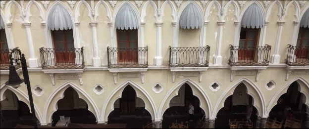
Comala is a town and municipality located in the Mexican state of Colima, near the state capital of Colima. It has been nicknamed the “White Village of America” as the facades of the buildings in town have all been painted white since the 1960s. The historic center of the town was declared a Historic Monument Zone and the town became a Pueblo Mágico in 2002. It is the municipal seat of the Comala Municipality, the local governing authority for over 400 other communities, including the former Nogueras Hacienda, the home of artist Alejandro Rangel Hidalgo.
Comala, better known as the Pueblo Blanco de America or White Town of America, in Nahuatl means “Lugar donde hay comales” or “Place where there are comales” (a rustic griddle). The Mexican writer Juan Rulfo chose the name of this town for his literary work Pedro Paramo. There are many features that stand out in the town; the white houses with their red tile roofs, the main square adorned by a kiosk brought from Germany, the Portals or archways that are popular for enjoying snacks and traditional drinks of the region, and the Parish of San Miguel Arcangel that was built in the 18th century. The town is surrounded by 3 natural boundaries: To the north the Volcano of Fire and the Nevado de Colima, and to the east the Cerro Grande that protects the Biosphere Reserve of Manantlan. The surrounding region is a great setting for various ecotourism and adventure activities. Before, it was common for Comala to be regarded as a tourist attraction from the city of Colima. But more recently, after being named a Pueblo Magico de Mexico or Magical City of Mexico by the Secretary of Tourism, it has developed more services such as several family-run hostels, some gourmet restaurants, artisan shops and tour guides. This allows its visitors to enjoy a pleasant and entertaining trip with all the necessary services. Comala shines for its quality of life, the beauty of its streets, the purity of the people’s traditions, and the efforts to preserve its legacy.
http://en.travelbymexico.com/comala/places-to-visit/?nom=ecomcomala
8. Contact Information
City Mayor: Leoncio Morán Sánchez
Contact number: +52 (312) 316 3821
Govt. Office Address: Profesor Gregorio Torres Quintero 85, Zona Centro, Colima, Col.
Facebook: https://www.facebook.com/LeoncioMoranL8
Twitter: https://twitter.com/leonciomoranL8
e-mail: secretaria.particular@colima.gob.mx
