Ciudad Juárez, Chihuahua 作者: 来源: 发布时间:2021-03-22
1. Basic data
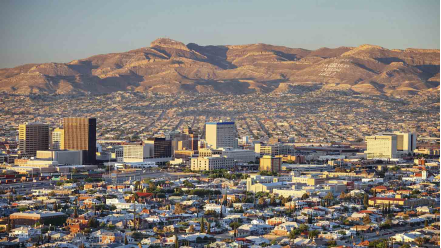
Pop.: 1,321,004
Area: 321.19 km2
Elev.: 1,137 masl
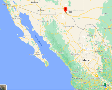
Ciudad Juárez location in Mexico within the state of Chihuahua
https://goo.gl/maps/oTwN5JyXw8inkgYLA
2. Natural geography
Desert bushes predominate, distributed from the plains and deserts of the northeast (Samalayuca dunes). It is followed by the coniferous and oak forests that develop in the Sierra Madre Occidental, in addition to the grasslands in the central plateaus. There are also natural protected areas for the conservation of wild flora and fauna and a forest reserve. Agriculture is practiced in the valleys and occupies 8% of the surface of the state.
Mexican wolf, Chihuahua minnow, frog, Alicante lizard, prairie dog and river otter. In the bushes: desert fox, rattlesnake, desert tortoise and kangaroo rat. In coniferous and oak forests: rat and ground and flying squirrel, bat, desert and mountain shrew and owl. In the grasslands: skunk, bighorn sheep and puma. Endangered animals: field mouse, black bear, Arizona shrew, western mountain parrot, American bison and coyote.
http://biodiversidad-chihuahua.blogspot.com/2014/08/la-biodiversidad-de-juarezchihuahua.html
Weather
Köppen Classification: Tropical and Subtropical Desert Climate
This climate is dominated in all months by the subtropical anticyclon, or subtropical high, with its descending air, elevated inversions, and clear skies. Such an atmospheric environment inhibits precipitation. Most of Earth's tropical, true desert climates occur between 15° and 30° latitude. The most extreme arid areas also are far removed from sources of moisture-bearing winds in the interiors of continents and are best developed on the western sides of continents, where the subtropical anticyclone shows its most intense development. An exception to the general tendency for aridity to be associated with subsidence is in the Horn of Africa region, where the dryness of Somalia is caused more by the orientation of the landmass in relation to the atmospheric circulation. Both the high- and low-sun monsoonal winds blow parallel to the coast, so that moisture-laden maritime air can penetrate over land only infrequently.
The Köppen Climate Classification subtype for this climate is "Bwk". (Tropical and Subtropical Desert Climate).
The average temperature for the year in Ciudad Juárez - Centro is 64.2°F (17.9°C). The warmest month, on average, is July with an average temperature of 82.6°F (28.1°C). The coolest month on average is January, with an average temperature of 45.0°F (7.2°C).
The highest recorded temperature in Ciudad Juárez - Centro is 120.2°F (49°C), which was recorded in June. The lowest recorded temperature in Ciudad Juárez - Centro is 3.2°F (-16°C), which was recorded in January.
The average amount of precipitation for the year in Ciudad Juárez - Centro is 10.0" (254 mm). The month with the most precipitation on average is July with 2.0" (50.8 mm) of precipitation. The month with the least precipitation on average is April with an average of 0.2" (5.1 mm). In terms of liquid precipitation, there are an average of 41.8 days of rain, with the most rain occurring in July with 6.7 days of rain, and the least rain occurring in April with 1.3 days of rain.
https://www.weatherbase.com/weather/weather-summary.php3?s=988213&cityname=Ciudad+Ju%E1rez+-+Centro%2C+Chihuahua%2C+Mexico&units=
Getting there and around
A passport is required to enter the United States. Juarez is part of Mexico's zona frontera, and no visa or passport is required to enter from the United States. Pedestrians are rarely stopped or asked for identification. Vehicles may be stopped at random: usually indicated by a red light at the border crossing. Your vehicle may be searched if stopped, and the most serious matter is to carry a firearm or ammunition without a permit to do so: even one spent shell casing may result in serious charges.
Highways exiting Juarez have checkpoints that do require foreigners to present a visa. If you do not have one, you may fill out a tourist card at the checkpoint.
By car
From the rest of Mexico, Juarez is accessible by Mexican Federal Highway 2 which runs along the United States border and Mexican Federal Highway 45 which heads south to Chihuahua.
From the United states, US Highways 62 (Stanton Street in El Paso) and 54 (also known as the Patriot Freeway) end at the Mexican border and are the main international crossings from the United States. Interstate 10 is the major highway leading to El Paso.
Near the Stanton Street bridge in downtown El Paso, most visitors that come for a single day choose to park on the US side of the border and walk across the bridges as to avoid dealing with traffic, lack of parking in the city center, and long waits for vehicles reentering the United States. Parking is generally $3.00 U.S. near the bridges. Be aware that the Stanton St. bridge, and the more westerly Paso del Norte bridge, allow auto traffic only northbound, into the US. However, pedestrians can use both bridges in both directions.
By plane
Abraham González Airport (IATA: CJS, ICAO: MMCS) offers flights to several destinations in Mexico, including Chihuahua, Monterrey, and Mexico City. El Paso International Airport (IATA: ELP) is the most convenient airport for U.S. travelers.
Get around
There is a public bus system in Juarez; however, it is not very easy to use and is often overlooked by tourists. In general, buses have their final destination on a board in the front window. They make frequent stops, and often run in close succession to one another; if you miss a bus, another of the same route is likely to appear in a matter of minutes. Many routes continue to run overnight, if you have no choice but to use them, exercise extreme caution on buses at night and buses that go into poorly policed barrios of the city (especially to the west and south). In recent weeks, buses have been targeted in attacks, mainly aimed to collect protection money for route operators.
Uber came to Juarez in 2017 and can be summoned using the same app as in the US. Taxis are abundant and inexpensive, but always ask for the ride fee and if possible ask two different drivers to get the best fare. Taxis are not metered, and initial fares may be given based on one's perceived ability to pay (a tourist or wealthier Mexican may be quoted a higher fare). However, most sites of touristic interest in Juarez can be reached by walking in the historic center. Upon arrival in Juarez, it is likely that most foreigners will received by a plethora of taxi drivers offering to drive them to the market. While the market cannot be seen from the border crossing, it is a relatively short walk: after crossing the Santa Fe street bridge, walk down Avenida Juarez to 16 de Septiembre, turn left and then walk about seven blocks (street blocks are much smaller in Juarez than in neighboring El Paso).
Driving in Juarez, while less chaotic than in Mexico City, is not recommended for a casual visitor. While the lack of high-speed freeways means many accidents that happen in the central parts of the city are relatively minor, fender benders in Mexico may involve frustrating red tape. If you drive in Juarez, make sure you have Mexican automobile insurance as not having Mexican insurance may result in criminal charges and a visit to jail.
Most larger businesses have parking lots with attendants that will ask for a nominal fee (25 US cents, or two to three pesos). Watch where you park; cars that are illegally parked on streets may have their license plates removed by a transit cop. The idea is to ensure you will pay the fine before leaving the country (and your plates should be returned after doing so). If this happens to you, the ticket should indicate where to pay your fine, should you chose to do so (you should be able to re-enter the United States in any event, but you may face some added complications with a missing plate).
3. GDP: 4,996 M USD
4. Industry
The El Paso Regional Economic Development Corporation indicated that Ciudad Juárez is the metropolis absorbing "more new industrial real estate space than any other North American city." The Financial Times Group through its publication The Foreign Direct Investment Magazine ranked Ciudad Juárez as the "City of the Future" for 2007–2008. The El Paso–Juárez area is a major manufacturing center. CommScope, Electrolux, Bosch, Foxconn, Flextronics, Lexmark, Delphi, Visteon, Johnson Controls, Toro, Lear, Boeing, Cardinal Health, Yazaki, Sumitomo, and Siemens are some of the foreign companies that have chosen Ciudad Juárez for business operations.
The Mexican state of Chihuahua is frequently among the top five states in Mexico with the most foreign investment. Many foreign retail, banking, and fast-food businesses have locations within Juárez.
Currently, Ciudad Juárez is the second city in the country with the largest number of IMMEX companies, with 319 economic units of this type. Exports from the city were equivalent to 38 billion dollars for 2014, with computers being the most common good. exported in monetary value.
Ciudad Juárez is positioned as a guide and approach with new investment opportunities in the energy aspect, derived from the new energy reforms in Mexico.
Key sectors:
·Machinery and electronics
·Transport vehicles
·Medical tourism
https://www.desarrolloeconomico.org/nuestras-industrias.php
5. Touristic sites
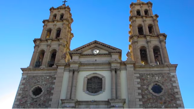
Ciudad Juárez Cathedral and Mission of Guadalupe
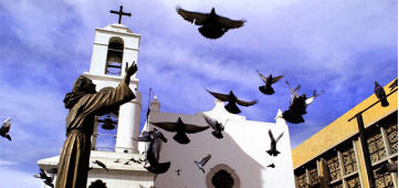
From this place, which was founded on December 8, 1659 by Fray García de San Francisco, the evangelization of the natives of the area began. It has been named "The Queen of Missions" for being the first of the Northern Passage. When the Indians revolted, it was used as a fortress and refuge by the Spaniards of New Mexico in 1680. Now you can admire its adobe walls, roof beams and palm tree trunks.
By 1659 Piro Indians had begun settling in the area of Paso del Norte. The Mission Nuestra Señora de Guadalupe was established by Fray García for them. This mission became the southernmost of the New Mexico chain of missions along El Camino Real from Mexico City to Santa Fe. The original structure remains as a side chapel of the Cathedral of Juarez. The Piro settlement formed the core of the original Ciudad del El Paso del Norte, which later became La Ciudad de Benito Juárez and is in the present-day state of Chihuahua. Many Native Americans were forced into Christianity. They rebelled against the Spanish a few years later.
https://www.zonaturistica.com/en/things-to-do/chihuahua/ciudad-juarez/ciudad-juarez-cathedral-and-mission-of-guadalupe
Museum of the Revolution in the Border (MUREF)
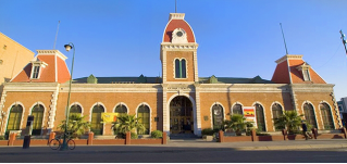
Built in the 19th century, at the time this building was border customs, inaugurated by Porfirio Díaz himself. It maintained its activities as such until 1965. After 20 years of abandonment, it was remodeled to finally open the MUREF in 2011. The museography is based on nine thematic axes related to how the border lived this decisive time in Mexico.
This museum tells the historic facts that happened in the border of Ciudad Juárez – El Paso between 1911 and 1914. The focal cores that give structure to our story are: The Maderista Revolution; Francisco Villa; the photographers that documented the historic facts; as well as the building, site and silent witness of these and other events. MUREF (Museum of the Border Revolution for its Spanish acronym), shows us the reason why the Juarenses (people from Juárez) are heirs and rightful representatives of a prestigious past. The original use of this historic building was the Border Custom since 1889. The first architectural intervention took place in 1909, for the interview to be held by US President William H. Taft and the President of México Porfirio Díaz.
https://www.zonaturistica.com/en/things-to-do/chihuahua/ciudad-juarez/museum-of-the-revolution-in-the-border
https://www.digie.org/media/16606?page=6#:~:text=MUREF%20(Museum%20of%20the%20Border%20Revolution%20for%20its%20Spanish%20acronym,the%20Border%20Custom%20since%201889
Samalayuca Dune Fields

A small part of the Chihuahuan Desert and impactful with an area of 17 hectares, is an ideal place for adventure tourism. On the white sand it is constantly moving because of the wind, you can do sandboarding, biking sand or hop on a 4x4 vehicle. If that does not catch your eye, enjoying the scenery on a walk with a guide. Opt to go in the fall or winter to avoid high temperatures.
The dunes are located along El Camino Real de Tierra Adentro (The Royal Road of the Interior), a 2,560km-long trade route between Mexico City and Santa Fe, the capital of the US state of New Mexico.
For many centuries before the arrival of the Spanish conquerors, indigenous nomads moved up and down the trail hunting and gathering useful plants.
The petroglyphs, or rock carvings, found in Samalayuca are a legacy of the early inhabitants of the area. The images date back 1,500 years and depict wild animals including horned sheep, stars and people.
The Spanish discovered the trail in the 16th Century and used it to reach the area where they eventually founded Santa Fe. After that, the route became fundamental for missionaries and colonisers and to transport goods and merchandise.
Centuries later, the dunes were used as a setting for several films, including Conan the Destroyer, starring Arnold Schwarzenegger, and David Lynch's Dune.
El Centro de ciudad Juárez
https://youtu.be/X4lyj1ZoNkg
6. History and Culture
As 17th century Spanish explorers sought a route through the southern Rocky Mountains, the Franciscan Friar García de San Francisco founded Ciudad Juárez in 1659 as "El Paso del Norte" ("The North Pass"). The Misión de Guadalupe de los Mansos en el Paso del río del Norte became the first permanent Spanish development in the area in the 1660s, although Native American peoples were already present. The Franciscan friars established a community that grew in importance as commerce between Santa Fe and Chihuahua passed through it. The wood for the first bridge across the Rio Grande came from Santa Fe, New Mexico in the late 18th century. The original population of Mansos, Suma, Jumano, and other natives from the south brought by the Spanish from Central New Spain grew around the mission. In 1680 during the Pueblo Revolt, most of the Piro Pueblo and some of the Tiwa people branch of the Pueblo became refugees, A Mission was established for the Tigua in Ysleta del Sur. Piro Pueblo colonial era settlements along El Camino Real, south of the Guadalupe Mission, included Missions Real de San Lorenzo, Senecú del Sur, and Soccoro del Sur. Presidio del Nuestra Senora del Pilar del Paso del Rio Norte was established near the Mission in 1683.
The population of the entire district was close to 5,000 in 1750 when the Apache attacked the other native towns and ranchos around the missions. Additional Presidios were established to counter them. One Presidio, San Elzeario, was established near El Porvenir in 1774, where it remained until being moved in 1788 to what is now San Elizario, Texas where that settlement grew up around that Presidio. Another was Presidio de San Fernando de Carrizal, which was established in 1774 at the San Fernando settlement that became present-day Carrizal, Chihuahua.
The 1848 Treaty of Guadalupe Hidalgo established the Rio Grande as the border between Mexico and the United States. The main channel of the Rio Grande had moved southwestward leaving the settlements of Ysleta, Socorro, and San Elzeario on the Camino Real on the north bank of the river, isolated from the rest of the towns, in Texas.
Other settlements on the east bank of the Rio Grande were not part of a town at that time; as the U.S. Army set up its installations settlements grew around it. This would later become El Paso, Texas. From that time until around 1930, populations on both sides of the border moved freely across it.
During the French intervention in Mexico (1862–1867), Benito Juárez's republican forces stopped temporarily at El Paso del Norte before establishing his government-in-exile in Chihuahua. After 1882, the city grew, in large part, because of the arrival of the Mexican Central Railway. Commerce thrived in the city as more banks began operating, telegraph and telephone services became available, and trams appeared. These commercial activities were under the firm control of the city's oligarchy, which consisted of the Ochoa, Samaniego, Daguerre, Provencio, and Cuarón families. In 1888, El Paso del Norte was renamed in honor of Benito Juárez.
The city expanded significantly thanks to Díaz's free-trade policy, creating a new retail and service sector along the old Calle del Comercio (now Vicente Guerrero) and September 16 Avenue. A bullring opened in 1899. The Escobar brothers founded the city's first institution of higher education in 1906, the Escuela Particular de Agricultura. That same year, a series of public works are inaugurated, including the city's sewage and drainage system, as well as potable water. A public library, schools, new public market (the old Mercado Cuauhtémoc) and parks dotted the city, making it one of many Porfirian showcases. Modern hotels and restaurants catered to the increased international railroad traffic from the 1880s on.
In 1909, Díaz and William Howard Taft planned a summit in Ciudad Juárez and El Paso, a historic first meeting between a Mexican and a U.S. president, and also the first time a U.S. president would cross the border into Mexico. But tensions rose on both sides of the border over the disputed Chamizal strip connecting Ciudad Juárez to El Paso, even though it would have been considered neutral territory with no flags present during the summit. The Texas Rangers, 4,000 U.S. and Mexican troops, U.S. Secret Service agents, FBI agents and U.S. marshals were all called in to provide security. Frederick Russell Burnham, the celebrated scout, was put in charge of a 250 private security detail hired by John Hays Hammond. On October 16, the day of the summit, Burnham and Private C.R. Moore, a Texas Ranger, discovered a man holding a concealed palm pistol standing at the El Paso Chamber of Commerce building along the procession route. Burnham and Moore captured, disarmed, and arrested the assassin within only a few feet of Díaz and Taft.
The city was Mexico's largest border town by 1910—and as such, it held strategic importance during the Mexican Revolution. In May 1911, about 3,000 revolutionary fighters under the leadership of Francisco Madero laid siege to Ciudad Juárez, which was garrisoned by 500 regular Federal troops under the command of General Juan J Navarro. Navarro's force was supported by 300 civilian auxiliaries and local police. After two days of heavy fighting most of the city had fallen to the insurrectionists and the surviving federal soldiers had withdrawn to their barracks. Navarro then formally surrendered to Madero. The capture of a key border town at an early stage of the revolution not only enabled the revolutionary forces to bring in weapons and supplies from El Paso, but marked the beginning of the end for the demoralized Diaz regime.
During the subsequent years of the conflict, Villa and other revolutionaries struggled for the control of the town (and income from the Federal Customs House), destroying much of the city during battles in 1911 and 1913. Much of the population abandoned the city between 1914 and 1917. Tourism, gambling, and light manufacturing drove the city's recovery from the 1920s until the 1940s. A series of mayors in the 1940s–1960s, like Carlos Villareal and René Mascareñas Miranda, ushered in a period of high growth and development predicated on the PRONAF border industrialization development program. A beautification program spruced up the city center, building a series of arched porticos around the main square, as well as neo-colonial façades for main public buildings such as the city health clinic, the central fire station, and city hall. The cathedral, built in the 1950s, gave the city center the flavor of central Mexico, with its carved towers and elegant dome, but structural problems required its remodeling in the 1970s. The city's population reached some 400,000 by 1970.
Juárez has grown substantially in recent decades due to a large influx of people moving into the city in search of jobs with the maquiladoras. As of 2014 more technological firms have moved to the city, such as the Delphi Corporation Technical Center, the largest in the Western Hemisphere, which employs over 2,000 engineers. Large slum housing communities called colonias have become extensive.
Juárez has gained further notoriety because of violence and as a major center of narcotics trafficking linked to the powerful Juárez Cartel, and for more than 1000 unsolved murders of young women from 1993 to 2003.
7. Contact Information
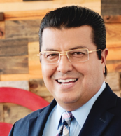
City Mayor: Héctor Armando Cabada
Contact number: +52 (656) 737 0000
Govt. Office Address: Av. Francisco Villa 950 N., Centro, C.P. 32000, Juárez, Chihuahua
Twitter: https://twitter.com/armando_cabada
FB: https://www.facebook.com/ArmandoCabadaOficial
Website: http://www.juarez.gob.mx
