ampeche City, Campeche 作者: 来源: 发布时间:2021-03-21
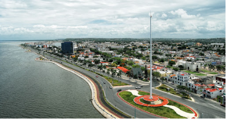
1. Basic data
Pop: 220,389
Area: 3,410.64 km2 (munip.)
Elev: 10 masl
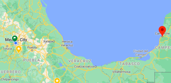
Huatulco location in Mexico within the State of Oaxaca
https://goo.gl/maps/FcXpFuBNHsy6GMZM8
2. Natural geography
The flora and fauna of Campeche represents one of the most diverse in the tropical region of Mexico, located in the southeast of the country, which has extensive areas of jungle. It has a sub-humid tropical climate with a warm temperature (average 24.5 ° C) and rainfall that varies from 500 to 2,000 mm per year.
Aquatic vegetation dominates the southwestern coast of Campeche, where the Terminos lagoon and its environment of wetlands and grasslands are located. To the north of San Francisco de Campeche, its capital, there is an enclave of peten vegetation, which are islands of trees in the middle of marsh vegetation.
Campeche possesses a huge biodiversity. Among its species it includes: achiote (Bixa orellana); campeche tree; canistel; ebony, mangroves, palm trees, among many others, and coatis; crocodiles; jaguars; juaguarundies; howling monkeys; wild turkeys, and other various species.
https://www.lifeder.com/flora-fauna-campeche
Weather
Köppen Classification: Tropical Savanna Climate
Tropical savanna climates have monthly mean temperature above 18°C (64°F) in every month of the year and typically a pronounced dry season, with the driest month having precipitation less than 60mm (2.36 in) of precipitation. In essence, a tropical savanna climate tends to either see less rainfall than a tropical monsoon climate or have more pronounced dry seasons than a tropical monsoon climate. Tropical savanna climates are most commonly found in Africa, Asia and South America. The climate is also prevalent in sections of Central America, northern Australia and North America, specifically in sections of Mexico and the state of Florida in the United States.
The Köppen Climate Classification subtype for this climate is "As". (Tropical Savanna Climate).
The average temperature for the year in Campeche is 80.6°F (27°C). The warmest month, on average, is May with an average temperature of 85.3°F (29.6°C). The coolest month on average is January, with an average temperature of 74.7°F (23.7°C).
The highest recorded temperature in Campeche is 113.0°F (45°C), which was recorded in May. The lowest recorded temperature in Campeche is 36.5°F (2.5°C), which was recorded in May.
The average amount of precipitation for the year in Campeche is 40.8" (1036.3 mm). The month with the most precipitation on average is September with 8.0" (203.2 mm) of precipitation. The month with the least precipitation on average is March with an average of 0.5" (12.7 mm). In terms of liquid precipitation, there are an average of 86.4 days of rain, with the most rain occurring in July with 14.8 days of rain, and the least rain occurring in April with 1.3 days of rain.
Getting there and around
Get there
By Air – You can get to Campeche by plane from Mexico City, and Cancun. The airport is just a couple of miles away from the city. You can either hire a private taxi, or a Collectivo Taxi (a minibus that drops each of the passengers at their required destination in geographical order) from the airport to town. The latter is considerably less expensive.
By Bus – Regular long distance buses make the journey from Mexico City to Campeche daily; the journey takes 18 hours, sometimes stopping at Villahermosa en route. Regional buses travel daily and frequently from Merida and Cancun and Villahermosa.
By Car – There are now fast roads connecting this region to Merida, Cancun, Oaxaca, Mexico City. The drive is a long one from Mexico City, but you’ll be rewarded by some stunning scenery. Most people tend to fly to the region and rent a car locally (see Getting Around, below).
Car Rental – To explore Mexico’s provincial towns and cities—including its beach locations and the scenery and attractions near them— consider renting a car for your visit. Having your own car will give you more flexibility than using public transport options and, in some cases, offer you access to places which are otherwise difficult to visit without the use of a car.
Get around
Local Buses – Local buses are available to take you around town and are very inexpensive.
The Tram – Campeche’s Tram System is an effective way to get around and there are also tourist trams which offer bi-lingual commentary and excursions around the key attractions of the city.
Taxis – Taxis in most of Mexico’s towns and cities are not metered, so agree your price before you get in. Taxi travel is very affordable in Mexico, in comparison to the USA, Canada and Europe, and so provides a viable means of public transportation in Mexico. Your hotel can arrange taxis for you; some post their rates on a board in the lobby; taxi hotel rates are usually higher than cabs you hail off the street. If you speak Spanish, you will have a distinct advantage and be able to negotiate a price with the driver.
Uber is expanding rapidly across Mexico and now offers services in cities across the country, including: Mexico City, Toluca, Cuernavaca, Puebla, Querétaro, León, Aguascalientes, San Luis Potosí, Guadalajara, Monterrey, Hermosillo, Tijuana, Mexicali, and Mérida. Uber has been adding Mexican cities to its network every year, check for availability when you arrive at your destination in Mexico.
Cabify is developing also and currently operates in cities including Mexico City, Toluca, Monterrey, Puebla, Querétaro and Tijuana. Check for availability in the city you are visiting.
The services offers people with smartphones a way to book a cab through a mobile app for a pre-agreed price. Fares are comparable with Sitio type cabs (see above), and sometimes trade at a premium to this when local demand increases.
https://www.mexperience.com/transport/taxi-travel-in-mexico/#51
3 . Economy
GDP: 19 M USD
4.Industry
The economy of San Francisco de Campeche is based primarily on the services sector: commerce, tourism, communications, public administration, public services. There are also various maquiladoras textiles installed in the city, and small and medium-sized enterprises generally associated with the exploitation of primary products, forming the secondary sector. The primary sector persists through fishing activity. In recent years tourism has had a strong boost in the State of Campeche.
5. Touristic sites
Colonial Center
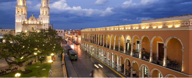
The city’s Cathedral, Catedral de la Concepcion Inmaculada, stands just off the main Zocalo (Parque Principal); it was completed early in the 18th century.
The Palacio de Gobierno (Government Palace) is an ultra modern building, built on reclaimed land, northwest of the Parque Principal just off the Plaza de la Republica.
Fuerte de San Miguel (St Michael’s Fort) on the southwest side of the city is host to a fine archaeological museum, housing Mayan artifacts from the archaeological ruins at Edzna and Jaina.
The city’s narrow streets and pastel-colored houses are a major attraction. In the famous neighborhood of San Roman, you can visit the church where the Black Christ is hosted; a six feet ebony statue brought to Mexico from Italy in 1575. The Tram can take you here (see Trams, below).
Campeche’s Port Bulwarks
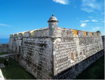
The city’s Bulwarks (7 of the original 8 still stand) can be toured on foot, along Avenida Circuito Baluartes (Baluartes is Spanish for bulwarks); some of them now house visitor attractions.
Baluarte de Nuestra Señora de la Soledad is host to the Museo de Estelas Maya; offering a collection of Mayan artifacts.
Baluarte de Santiago hosts the miniature Jardin Botanico Xmuch Haltun, a collection of tropical plants and fountains.
Baluarte de San Pedro, situated in the middle of an intersection is a local crafts exhibition and sales center.
Baluarte de San Carlos has the Museo de la Ciudad (city museum) which includes a scale model of the old city. There are sea views from the roof.
Baluarte de San Francisco, Baluarte de San Juan and Baluarte de Santa Rosa are the last three of the Bulwarks which can be visited.
Campeche’s Trams (“Tranvias“)
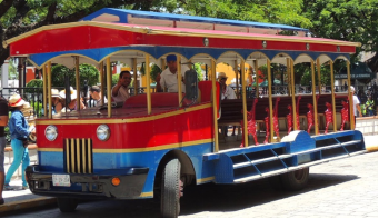
One of the best ways to see the delights of the city is to take a ride on one of the Tranvias (Trams) which offer bi-lingual commentary (English and Spanish). The Tranvia de la Ciudad passes by most of the main attractions and picturesque colonial neighborhoods in Campeche including San Roman; while El Guapo (“The Handsome One”) takes a route along the seafront to the Fuerte de San Miguel (see above). Both trams start the Zocalo (Parque Principal).
Daily bilingual tours by tranvía (trolley) depart from the Plaza Principal (minimum six people, 45 minutes). They cover Campeche's historical center, traditional neighborhoods and part of the malecón. Occasionally another trolley, El Guapismo, goes to Fuerte de San Miguel leaving half an hour to visit the Museo Arqueológico de Campeche. Check schedules at the ticket kiosk in the Plaza Principal.
https://www.mexperience.com/travel/colonial/campeche
https://www.lonelyplanet.com/mexico/yucatan-peninsula/campeche/activities/tranvia-de-la-ciudad/a/poi-act/1014685/361681
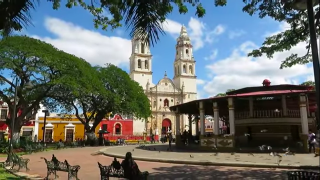
You NEED to visit Campeche Mexico!
https://youtu.be/vee6_NbFXGk
6. History and Culture
Founded in 1540 by Francisco Montejo, Campeche was terrorized by pirates and marauders until the city started fortification in 1686.
San Francisco de Campeche was originally an indigenous village, Ah Kim Pech, where the Spanish first landed in Mexico in 1517. The city of Campeche was founded in 1540 and fortified against pirates during the 17th century. It still has the appearance of a fortress. Historical monuments and buildings, such as the Franciscan cathedral, old Maya ruins, and the old city walls and forts, attract many tourists.
The fortifications system of Campeche, an eminent example of the military architecture of the 17th and 18th centuries, is part of an overall defensive system set up by the Spanish to protect the ports on the Caribbean Sea from pirate attacks like the 1663 Sack of Campeche.
The state of preservation and quality of its architecture earned it the status of a World Heritage Site in 1999.
First expeditions
The first expedition of the Spaniards that touched the coasts of Campeche was commanded by Francisco Hernández de Córdoba in 1517. he left the island of Cuba on February 8, touched Isla Mujeres and Cabo Catoche the first days of March, continued to pay for the peninsula and arrived in Campeche on Sunday of San Lázaro March 22, 1517, which is why Hernández de Córdoba baptized the place with that name. The natives of Campeche welcomed the Spaniards and touched their beards and their people.
The chronicle of Bernal Díaz del Castillo narrates that a few days later they sighted a village planted on the coast, landed cautiously and set foot on land they discovered "Can Pech".[7] This took place on Sunday March 22, 1517. In need of water, the Spaniards landed with the help of bats and supplied themselves in a well. As the Mayans approached, the Spaniards indicated by means of signs that they came in peace; the chief of the region asked them if they came from where the sun rises, mentioning the word "castilán". The Spaniards, surprised at this word, responded affirmatively, and Cacique invited them to his population, where copal was lit. By means of signs, the "halach uinik" indicated to the expeditionaries that they should leave the place before the fire went out. Meanwhile, warriors were arriving at the place. From the experience of Cabo Catoche, the Spanish preferred to leave. (They would be surprised by a "north" wind and with the rough sea, they would lose the water supplied, having to land again for their bad luck in Chakán Putum where the strongest battle between Mayans and Spaniards would take place.)
Conquest
After the conquest of Tenochtitlan, Francisco de Montejo traveled to Spain, where he requested Carlos V permission to conquer the Yucatan Peninsula. In 1526, the Spanish crown granted Montejo the title of "Adelantado, governor, sheriff and captain general of Yucatan". The conquests of Champotón and Campeche, were part of the Conquest of Yucatan, which was carried out in three stages.
In the first stage (1527 to 1529), Montejo ventured along the eastern coast of the peninsula with the help of the captain Alonso Dávila, whom he had known since Cortes' expedition, but they were repelled by the Maya.
In the second stage (1530-1535), Montejo ventured into the west, and managed to found "Salamanca de Campeche" in 1531. Alonso Dávila was sent by Montejo to cross the peninsula south and founded Villa Real in Bacalar, but this position had to be abandoned.
Montejo's son known as Montejo "el Mozo" is defeated in the royal city of Chichén Itzá towards the end of 1534, so in 1535 the Spaniards leave the peninsula for five years.
Towards 1540, "the Adelantado" assigned Lorenzo de Godoy to install the first garrison in San Pedro de Champotón, which they maintained with many difficulties, since they did not have people or soldiers. Montejo "the Nephew" helped keep the garrison and changed its name to "Salamanca de Champotón". "The Adelantado" arrived in Ciudad Real de Chiapa (San Cristóbal de las Casas), in 1540, and from there he gave instructions to Francisco Gil to be in charge of Champotón's position and thus "El Mozo" and "the Nephew" would begin the advance north. In 1546, when the conquest of Yucatan seemed to be over, "the Adelantado" and his wife traveled to San Francisco de Campeche to meet with his son "El Mozo" and "El Nephew". The Maya had organized in secret, and on the night of November 8 to 9 (5 Cimi 19 Xul, death and end of the Mayan calendar) a great rebellion broke out. "El Mozo" and "el Sobrino" would once again take up arms to "reconquer" the peninsula and submit the rebellions a year later.
Viceroyalty period
The town of that time was built around a square occupied solely by the pillory, a column that served as a symbol of power and Spanish justice. Around the square the parish of Our Lady of the Purest Conception, the Audience and the houses of the highest-ranking conquerors were built. The market would be built around a smaller plaza and commercial life developed. The jail, the Municipal Palace and the defense tower against the fireworks would be built soon after.
The villa founded by the Spaniards was somewhat removed from the locality Mayan people. The Spaniards made their life around the square, in the current neighborhood of San Román, while the natives were added in the old pre-Hispanic settlements, currently the neighborhoods of San Francisco and Siete de Agosto. The Naboríos, indigenous Mexicans who arrived with the conquerors, occupied the San Román neighborhood and the population of slaves from Africa the neighborhoods of Santa Ana and Santa Lucía.
Maritime trade conditioned the development of the town, so it was designed with a Renaissance model: a regular trace in checkerboard around an eccentric square that, according to the ordinances of the Spanish Crown, should serve for parties and ceremonies, oriented around its bay.
Once established Francisco de Montejo y León "el Mozo" in the town, the city became the base of operations for the conquest of the rest of Yucatán (1542 - 1546) which led to the occupation of Ichkanzihóo (Th'o), the old city of the Itzáes. then abandoned, where the provincial capital was founded, Mérida in 1542.
The "armed" conquest was followed by the ideological "conquest, which consisted of the implantation of European doctrinal beliefs, particularly that of the Catholic religion. The first religious order that He arrived in Campeche was that of the Franciscan s, who arrived in Campeche in 1535, but had to retire due to a series of difficulties raised by both indigenous and Spanish people, to return five years after that Montejo was established in Campeche, in 1540. Upon his return, they began the construction of a temple and convent dedicated to San Francisco close to the population Maya, its founder was Fray Luis de Villalpando.
The evangelization was similar throughout New Spain, the Franciscans had no more difficulty once the language barrier was overcome, and they were the only order that carried out this task in the province of San José, which It was how the Yucatan Peninsula was named. The evangelists had to overcome certain difficulties, such as the differences of a community culture, such as that of the natives.
In 1542, the king proclaimed the calls New Laws, which established the freedom of the Indians as subjects of the Crown. Slavery was legally abolished, but would continue by other means. The parcel subject a certain number of peoples to a Spaniard, to whom they had to pay in kind (wax, cotton blankets) and labor. Those who were not entrusted were under the royal jurisdiction and received the name of "peoples of the Royal Crown." The indigenous tributaries of the encomiendas español, continued to suffer a treatment that was practically slavery. The friars of the different religious orders present fought to defend the rights of the indigenous people, preserve their freedom and limit the abuses of the conquerors. Thanks to this, in 1547, Felipe II of Spain issued a royal identity card in favor of the personal freedom of the natives, and to make sure that their interests were fulfilled, he created a City Hall Mayor for the province of Yucatán.
Trade and Piracy
Campeche's position in the Gulf of Mexico made it the main port of the Yucatan Peninsula, standing out as a point of connection with the foreigner, which allowed the economic boom and population growth. From there, from early times, the cargoes of the so-called palo de Campeche, also known as "dye stick", a native product of the region that would lead to large estates, among which are counted, Uayamón, Xanabchakán and Mucuychacán, to mention three of them, and also of salt. The port of Campeche also gained fame for its Shipyards industry.
The commercial monopoly of Spain, implemented by the House of Hiring of the Indies to their domains, which prohibited them from trading even among themselves and with other nations, led to illegal practices such as piracy. One of the measures to stop them was promulgated in 1616 by the Mayor of Yucatan Luis de Céspedes y Oviedo, which involved the creation of a license on the cutting and trade of the Campeche stick, as well Like new taxes. This first measure was insufficient and counterproductive, because far from bringing down piracy, he encouraged it. In 1629, the King of Spain Felipe IV created a navy coast guard to protect trade, but this measure also did not give the expected results, neither did the military garrison to protect the city implanted by Mayor Centeno Maldonado. The constant pressures from other European nations and the continuing uprisings in their Dutch positions made it impossible to adopt new measures against piracy, which remained in full swing.
Among the pirates most famous that docked at Campeche are John Hawkins, Francis Drake, Laurens de Graaf, Cornelius Jol, Jacobo Jackson, Michel de Grandmont, Portuguese Bartholomew, William Parker, Jean David Nau, Edward Mansvelt, Henry Morgan, Lewis Scot, Roche Brasiliano and Jean Lafitte. On January 27, 1661, a fleet of filibusters appeared in the port of San Francisco de Campeche and, although it did not disembark, looted two well-loaded commercial frigates, which barely arrived and then quietly withdrew, without being chased, because that day there was no armed ship in the bay capable of hunting him. The head of this filibuster expedition was called Henry Morgan.
A very feared pirate in the town of Campeche was Laurens de Graaf or Lorencillo, who was Dutch and had served the king of Spain fighting filibusters. But then he also dedicated himself to piracy. In 1685 he attacked and took the town of Campeche and twenty other towns in the area. He spent two months and captured so many prisoners and stole so many jewels and pieces of silver that filled the cargo of his ship. He was chased by three Spanish frigates with cannons. The pirate dodged the attacks, threw the entire load into the sea so that the ship achieved greater speed and, with wind in favor, moved away quickly.
Another pirate was El Olonés whose real name was Jean David Nau. He committed innumerable and famous stumbling against the Spanish viceroyalty of the mainland. In a terrible storm, he lost his ship on the coast of Campeche. All the men were saved, but, arriving on land, the Spanish persecuted them by killing most of them, and also hurting the Olonés. Not knowing this how to escape, he thought about saving his life through a ploy: he took several handfuls of sand and mixing it with the blood of his own wounds he smeared his face and other parts of his body. Then, hiding with great skill among the dead, he remained motionless until the Spaniards left the field of struggle. Since they were gone, he retired to the forest, sold his wounds and took care of them until heal and then headed to the City of Campeche perfectly disguised. In the city, he spoke with certain slaves to whom he promised freedom in case they obeyed him. They accepted their promises and stealing a canoe at night, threw themselves into the sea with the Olonés.
Elevation to City rank
The coat of arms held by the city of San Francisco de Campeche was granted in 1777 by the king of Spain Carlos III, being elevated from the title of villa to that of city.
Before the current shield was adopted, there was a process to constitute a shield as an officer. The first project was presented in 1772 before the possible elevation to the title of city of the town of San Francisco de Campeche, when requested by the Cabildo de Campeche in a contest for the election of shield de Armas. The first design was submitted by Juan Antonio Rexo and Peñuelas on September 24 of that year but was rejected on October 17 for not being subject to the rules of heraldry. Ramón Zazo and Ortega subsequently presented three projects; the first two were rejected but finally the third was approved in council council on November 7, 1777. The shield was approved by his majesty Carlos III of Spain with the certificate of: "the City Title is granted to the town of San Francisco de Campeche."
7. Contact Information
City Mayor: Eliseo Fernández Montúfar

Contact number: +52 (981) 811 1231
Govt. Office Address: Calle 8 325, Zona Centro, 24000 Campeche, Camp.
FB: https://www.facebook.com/eliseo.fernandezm.1
Twitter: https://twitter.com/EliseoFdzM
Website: https://www.municipiocampeche.gob.mx
E-mail: oficina@presidencia.municipiocampeche.gob.mx
