Bahia de Banderas, Nayarit 作者: 来源: 发布时间:2021-03-20
1. Population and Area
Pop.: 124 209 (aprox.)
Area: 773 km2
Elev.: 165 masl
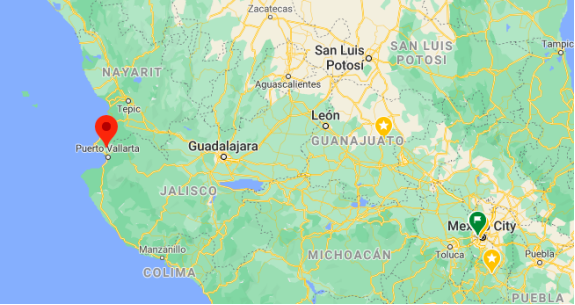
Bahía de Banderas location in Mexico and within the state of Nayarit
https://goo.gl/maps/AR43Y8ErJ1516jC67
2. Natural geography
The Bahía de Banderas is regarded by most geologists as the original attachment point for the southern cape of the Baja California Peninsula before it was rifted off the North American Plate millions of years ago, forming the Gulf of California.
The bay, which is part of the system of bays known as the Nayarit Riviera, is bounded on the north by Punta Mita (Mita Point), and on the south by Cabo Corrientes (Cape Corrientes). Its coastline is approximately 100 kilometres (62 mi) long. Though locally regarded so, it is not the largest bay in Mexico.
Bahía de Banderas (Banderas Bay) is also an important breeding and birthing ground for the humpback whale.
Unlike the rest of the municipalities of Nayarit, Bahía de Banderas follows the Central Time Zone, as used in the neighboring municipality of Puerto Vallarta, Jalisco. This is in order to allow for greater integration with the touristic region of Puerto Vallarta, as well as to prevent timezone confusions that could lead to missed flights on account of the local airport being across the state border in Puerto Vallarta. This timezone is represented in the Olson database as America/Bahia_Banderas.
Weather
The penetration of the coastal effect towards the continent is bordered by four mountainous systems that surround it: Sierra Vallejo to the north; Sierra El Cuale to the east; Sierra El Tuito, to the southeast; and Sierra Lagunillas to the south. The latter two, due to their great height (more than 2,000 meters above sea level), allow a large part of the southern and eastern coast of the area to serve as moisture capture systems during the rainy season (Cupul, 2001–2002).
In this region of the BB, Nayarit – Jalisco (Figure 1), it is presented in its lower part, jungle and sub-deciduous tropical forest (Ramírez et al., 1999), in addition to mangrove forest in the El Quelele and Boca estuaries. Negra, both from Nayarit and El Salado in Jalisco. Deciduous tropical forest is distributed in the north and south of the Bay, while oak and pine-oak forests occur from 450 m of altitude (Ibid.).
Because it is a coastal area, the dominant wind flow (breeze) is terral; a diurnal sea-to-land wind flow caused by uneven warming between the land surface and ocean surface water (during the day the land heats up faster than water), and an evening land-to-sea wind flow ( after sunset the earth's surface cools faster than water).
Its climate presents a warm subhumid type in the coastal zone and below 700 meters above sea level, with annual average temperatures ranging from 22 to 28º C and with annual precipitation of 830 to 1,783 mm. While the semi-warm subhumid climate occurs in the mountains above 700 meters above sea level, with annual average temperatures ranging from 18 to 21º C and with annual precipitation of 940 to 1,350 mm. In both areas the rainy season occurs mainly between the months of June to October.
http://www.scielo.org.mx/scielo.php?script=sci_arttext&pid=S0188-46112012000300002
Getting there and around
Getting to the Nayarit Riviera is a breeze whether you are venturing via the highway system or travelling to one of the two airports in Riviera Nayarit that service the region.
By land
The Pacific Motorway is the main access highway into the state of Riviera Nayarit. This roadway also connects Tepic, the capital of Riviera Nayarit, with other important cities in Mexico such as Guadalajara and Mazatlán.
From north to south, Mexico is crossed by Federal Highway 15, which goes from Nogales to Mexico City (2165-km/1345-miles).
On the southern coast, Federal Highway 200 extends from Tepic down to the Guatemala border passing through all the main destinations and municipalities of Banderas Bay and Compostela, including Puerto Vallarta.
In the north, Highway 54 reaches San Blas, and Highway 15 connects with Santiago Ixcuintla.
Among the numerous projects underway to generate growth along this tourist corridor in Riviera Nayarit is the establishment of an ambitious highway network, with an estimated investment of more than 7.8 billion pesos (nearly 400 million USD)
The roadways will be divided into four expressways: Tepic- San Blas, Tepic-Compostela, Compostela-Las Varas, and Las Varas-Bucerías.
The Tepic-San Blas Highway reduces the driving distance between Tepic, the capital of Nayarit, and the Historic Port of San Blas down to only 20 minutes. Together with the new dock in San Blas, this coastal town will surely see a spike in domestic visitors.
Added to these routes will be the Jala-Puerto Vallarta freeway, which will spur even greater commercial and tourism growth, as well as the Tepic-Aguascalientes and Tepic- Zacatecas highways, linking the wonders of the Riviera Nayarit with the center of the country.
The first stretch of the Jala-Bahía de Banderas Highway, from Jala to Compostela, was recently completed. The second and third sections are underway. This new 105-mile highway will reduce the drive time from Guadalajara to Riviera Nayarit’s beaches from five hours to approximately two hours.
Below is a distance listing between major tourist towns in Nayarit, along the Pacific Coast of Mexico:
By plane
Flying to the Riviera Nayarit is now easier and more convenient for both national and international travelers.
There are two major airports in Riviera Nayarit: Tepic International Airport and the Puerto Vallarta International Airport.
Tepic International Airport (TPQ)
The Tepic International Airport (TPQ) is located just 1 hour east of the resort coastal area of San Blas in Riviera Nayarit, Mexico’s Pacific Coast’s oldest sea port. Below is a list of the regularly scheduled airlines with service to Tepic as well as the cities they fly from.
Airlines that fly to Tepic International Airport (TPQ):
·Aeromar Airlines from Mexico City
·Volaris Airlines from Tijuana City
https://www.rivieranayarit.com/getting-here/
Get around
Getting around the Bahia de Banderas region is very simple. There is a multitude of ways to get around, including UBER, taxi, bus, boat.
Certain towns and beaches like Yelapa can only be accessed by taking a water taxi. Around town, UBER is the quickest way to get from point A to point B. Taking a city bus is the most inexpensive way to travel around the bay. Buses can take you as far south as Boca de Tomatlan, and as far north as Sayulita.
3. Economy
The GDP in 2014, calculated using a parametric methodology was of 4315.6 millions of MXN.
https://dialnet.unirioja.es/descarga/articulo/4954700.pdf
4. Industry
Tourism is very important to the local economies, and the Bahía de Banderas coast is an important location of tourist facilities development in both states. Puerto Vallarta has been the longstanding primary resort destination and cruise ship port of the bay. However, beyond the city on the long 100 kilometres (62 mi) coastline, other attractive beaches and landscapes have since been developed to serve visitors, like Bucerías, Sayulita and Punta Mita.
Also, sea fishing and agriculture are complements to the mainly touristic economy. The main crops are corn (maize), beans, sorghum, tobacco, rice, watermelon and mango. Exotic fruits like papaya, litchi, and guanábana are also grown. Most of the planted area is irrigated. There are several packing houses for papaya and other fruits.
5. Touristic sites
Nuevo Vallarta
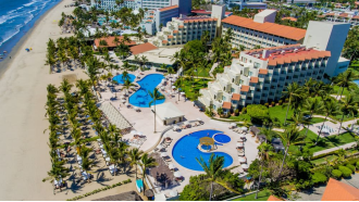
This complex is a planned residential-resort community located in the Mexican state of Nayarit. By automobile, it is about fifteen minutes north of Puerto Vallarta's Licenciado Gustavo Díaz Ordaz International Airport. Nuevo Vallarta receives many tourists from both the United States/Canada and also the United Kingdom. It has many malls and stores that accept payment in Mexican pesos or U.S. dollars.
Some activities you can spend your time with are aquatic sports (snorkel, scuba diving, windsurf, yate excursions), swimming with animals, visiting a turtle reserve, playing golf, among others.
https://es.wikipedia.org/wiki/Nuevo_Vallarta
Sayulita
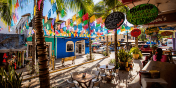
Recently labeled as Pueblo Mágico (Magic Town), Sayulita is one of the most recognized spots in the municipality of Bahia de Banderas; located approximately 40 minutes by car out of Nuevo Vallarta and one hour away of Puerto Vallarta.
This small, cosmopolite town is visited by hundreds of national and international tourists year through; however, summer is paradise to surf lovers and all those eager to learn to ride the waves.
In a highly friendly beach environment, tourists and foreigners coexist creating a community in harmony. Sayulita and its bohemian soul will make you vibe both day and night; you will forget your troubles and enjoy every small detail of your day.
There are characters always present in Sayulita. There are the youths with athletic bodies that walk to the beach every morning holding a surfboard on their heads; they go barefoot even if there are still lots of blocks to go to reach the sand. There are adventure lovers who stop here to hike through the jungle and look for almost virgin coasts In nearby towns. There are, too, the women traveling with breezy clothing and traditional textile jewelry, who walk through small streets ornamented with hanging “papel picado,” full of locals with unconventional souvenirs.
https://hospitalcmq.com/vacations/sayulita/
https://www.eluniversal.com.mx/english/sayulita-15-things-do-magic-town
Islas Marietas
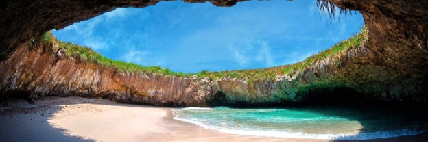
In terms of pristine natural beauty and scenic seaside vistas, few areas in the world are richer than the Marieta Islands. Protected as part of Islas Marietas National Park, these natural wonders are home to a number of native wildlife species, as well as some of the most breathtaking landscapes in all of Mexico.
The Bay of Banderas is one of the few places in the world that is a natural sanctuary for a profusion of natural land and sea life. Within the Bay of Banderas, there are few areas lusher in life than the waters surrounding Islas Marietas National Park. During the winter months, it is common to see humpback whales in the bay, since this is a centuries-old breeding ground and respite following their annual migrations. Dolphin encounters are a regular year-round occurrence. You may see them in large groups leaping out of the water or in pairs riding along near the bows of boats in the bay.
https://www.vallarta-adventures.com/en/tour/marietas-eco-discovery
Cruz de Huanacaxtle
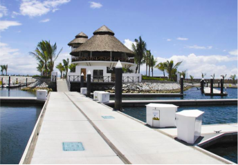
A fishing village for generations, this coastal town has been modernized thanks to the construction of the Riviera Nayarit Marina —the largest and most modern of the corridor. Nayarit Marina has helped to create a Nayarit destination that harmoniously combines the traditional life of a Mexican pueblo with the sophistication of a modern development. So, when visiting La Cruz, as the locals call it, you will have the opportunity to witness postcardworthy scenes such as the arrival of fishermen on the pier in their Panga boats loaded with a variety of fish.
https://www.rivieranayarit.com/destinations/la-cruz-de-huanacaxtle/
6. History and Culture
The territory currently occupied by the Municipality of Bahía de Banderas was inhabited during pre-colonial times by peoples or tribes belonging to the monarchy or Hueytlahtonazgo de Xalisco, which extended southward, outside the limits of what is currently the state of Nayarit, and was founded between the years 559 and 618. It is known that the Municipality of Bahía de Banderas was also a place of transit in the great migration that led the Aztec people to settle in the Valley of Mexico. The archaeological findings and testimonies located in Sayulita, Higuera Blanca, Punta de Mita, Valle de Banderas and San Juan de Abajo, where colonies of Nahuatlaca origin existed, tell us about this transit.
It was in the year 1525 that Francisco Cortés de Buenaventura, a relative of the conqueror, arrived on these coasts, at the height of a town called Tintoc. The natives welcomed him dressed in their colorful costumes and luxury of plumaria, which led to the name of the region. Subsequently, in 1530 Nuño Beltrán de Guzmán, practiced a violent and destructive colonization that originated a serious depopulation and ruin of the region, to the point that the bishop of Guadalajara said in 1605: “The Valley that they say of Banderas, formerly was the land most populated in this New Galicia and now it has nothing but small villages of little importance."
Much of the second half of the nineteenth century, the area that since the time of the conquest was called the Valley of Banderas, was preserved with a very low population density. Some of the localities that by 1893 gained some importance due to their number of inhabitants are: Valle de Banderas, with 250; San José del Valle, with 70; San Juan de Abajo, with 50; El Colomo, with 45; Mezcales, with 40; and Las Peñas, Jalisco (today Puerto Vallarta), with 60. The cultivation of corn, fishing and hunting were the activities that were practiced and were destined for self-consumption. In 1904 the Valle de Banderas Subprefecture was created and as of 1917, the Free and Sovereign State of Nayarit was constituted, it integrated the Municipality of Compostela. The current territory of Bahía de Banderas was practically oblivious to the armed confrontations that culminated in the triumph of constitutionalism and post-revolutionary struggles. In 1937, during the Cardenista period, the peasants of the region were endowed with a total of 26,648 hectares, forming 9 of the 13 ejidos that exist today. Only the one in Valle de Banderas was assigned 10,234 hectares and at least 1,433 of them were located on the other side of the Ameca River, in Jalisco territory.
From 1954 to 1958, the Valle de Banderas risk unit was built, initially dominating 2,500 hectares, and later it reached an area close to 10,000 hectares, which increased agricultural production. From 1955 to 1964, tourist activity took off in small hotels located in the town of Puerto Vallarta. In 1958 the construction of the Compostela-Puerto Vallarta highway began and it was concluded ten years later, allowing the commercial opening of the Banderas Valley. From 1965 to 1974, a great international projection of Puerto Vallarta and attraction of a growing number of tourists was generated and the Nayarit portion of the Bay of Banderas, of great natural attraction, benefited indirectly. 22 In order to promote a tourist development that would benefit the agrarian communities of this coastal area of Nayarit, the Federal Government decreed in November 1970 the creation of the Bahía de Banderas Trust, whose patrimony was established two months later with 5,162 hectares expropriated from the ejidos of Bucerías, Jarretaderas, Cruz de Huanacaxtle, Higuera Blanca and Sayulita, among others. The trustees formed an ejido union in 1972.
The promotion by the Trust marked the beginning of a process of expansion of investments and tourism infrastructure, which included the development of the Nuevo Vallarta subdivision, which, together with the surrounding coastal area, is the destination of large capitals and national and foreign visitors. Between 1975 and 1984 there was a rapid growth in the supply of accommodation in large and modern hotel facilities and full-time and time-share units; construction of new facilities such as the marina and golf course. Expansion of the hotel zone both north and south.
Starting in 1985, the accelerated growth in demand, as a result of the construction of large hotels and timeshare units, has promoted urban-tourist expansion with high densification in Puerto Vallarta. New tourism products in the Municipality of Bahía de Banderas that maintain the high-density model and that begin to modify the growth trends of the area (Nuevo Vallarta and Flamingos). In 1988, at the request of representative groups, who were considered marginalized by the municipal authorities of Compostela, the State Congress carried out a broad consultation process in the communities that bore fruit the following year with the decision to create the Municipality of Bahía de Banderas by decree number 7261 issued in December 1989. In 1995 the growth of Vallarta began to decrease and the growth trend towards Punta Mita was consolidated with new high quality products (Punta Mita and Costa Banderas).
7. Other Information of Interest
Zona Pacífico time
If you travel north of Puerto Vallarta you need to put your watch back one hour: Nuevo Vallarta, Bucerías, Punta de Mita and Sayulita officially lie within the Zona Pacífico (Pacific Zone), the equivalent of Canadian and US Mountain Time, which starts at the Jalisco/Nayarit state border, just north of Puerto Vallarta’s airport. However, because Nuevo Vallarta, Bucerías and Punta de Mita are so close to PV, most businesses work on Zona Central (US Central) times; Sayulita officially changed to Central time in 2011. If you are given a time followed by the word Jalisco, it means Zona Central; if followed by Nayarit, it is Zona Pacífico time.
8. Contact Information
City Mayor: Jaime Alonso Cuevas Tello

Contact number: +52 (329) 291-1870
Govt. Office Address: Morelos #12, Col. Centro. C.P.: 63731 Valle de Banderas, Bahía de Banderas, Nayarit.
Facebook: https://www.facebook.com/jaime.cuevastello.12
Website: https://www.bahiadebanderas.gob.mx/x
