Saint Paul, Minnesota 作者: 来源: 发布时间:2021-11-09
I.Population and Area
₋Area
Land: 51.98 sq mi (134.62 km2)
₋Population
Total: 285,068
Density: 5,927.43/sq mi (2,288.60/km2)
II.Natural Geography
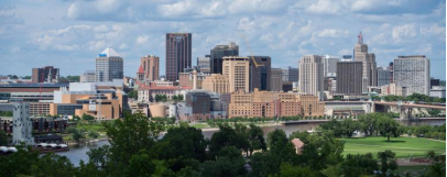
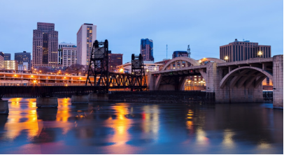
City Overview From Port
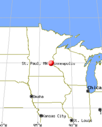
₋Saint Paul (abbreviated St. Paul) is the capital of the U.S. state of Minnesota and the county seat of Ramsey County, the state's smallest and most densely populated county. As of 2019, the city's estimated population was 308,096, making it the 63rd-largest city in the United States and the 11th-most populous city in the Midwest. The city lies mostly on the east bank of the Mississippi River in the area surrounding its point of confluence with the Minnesota River, and adjoins Minneapolis, the state's largest city. Known as the "Twin Cities", the two form the core of Minneapolis–Saint Paul, the 16th-largest metropolitan area in the United States, with over 3.6 million residents, and the third-largest in the Midwest.
₋Founded near historic Native American settlements as a trading and transportation center, the city rose to prominence when it was named the capital of the Minnesota Territory in 1849. The Dakota name for Saint Paul is "Imnizaska". Regionally, the city is known for the Xcel Energy Center, home of the Minnesota Wild, and for the Science Museum of Minnesota. As a business hub of the Upper Midwest, it is the headquarters of companies such as Ecolab. Saint Paul, along with its twin city, Minneapolis, is known for its high literacy rate.
₋The settlement originally began at present-day Lambert's Landing, but was known as Pig's Eye after Pierre "Pig's Eye" Parrant established a popular tavern there. When Lucien Galtier, the first Catholic pastor of the region, established the Log Chapel of Saint Paul (shortly thereafter to become the first location of the Cathedral of Saint Paul), he made it known that the settlement was now to be called by that name, as "Saint Paul as applied to a town or city was well appropriated, this monosyllable is short, sounds good, it is understood by all Christian denominations".
III.ECONOMY
₋In 2018, St. Paul, MN had a population of 308k people with a median age of 32.6 and a median household income of $59,033. Between 2017 and 2018 the population of St. Paul, MN grew from 306,604 to 307,701, a 0.358% increase and its median household income grew from $54,290 to $59,033, a 8.74% increase.
₋Website: https://datausa.io/profile/geo/st.-paul-mn
IV.Industrial Characteristics
₋The Minneapolis–Saint Paul–Bloomington area employs 1,570,700 people in the private sector as of July 2008, 82.43 percent of which work in private service providing-related jobs.
₋Major corporations headquartered in Saint Paul include Ecolab, a chemical and cleaning product company which was named in 2008 by the Minneapolis / St. Paul Business Journal as the eighth best place to work in the Twin Cites for companies with 1,000 full-time Minnesota employees, and Securian Financial Group Inc.
₋The 3M Company is often cited as one of Saint Paul's companies, though it is located in adjacent Maplewood. 3M employs 16,000 people throughout Minnesota. St. Jude Medical, a manufacturer of medical devices, is directly across the northern border of Saint Paul in Little Canada, though the company's address is listed in Saint Paul.
₋The city was home to the Ford Motor Company's Twin Cities Assembly Plant, which opened in 1924 and closed at the end of 2011. The plant was in Highland Park on the Mississippi River, adjacent to Lock and Dam No. 1, Mississippi River, which generates hydroelectric power. The site is now being cleared of all buildings and tested for contamination to prepare for redevelopment. As the lead developer, the Ryan Company has released a proposed set of zoning changes that will shape how the land will be used.
₋The city of Saint Paul has financed city development by use of tax increment financing (TIF). In 2018, the city had 55 TIF districts. Some projects that have benefited from TIF funding include the St. Paul Saints stadium, and the affordable housing along the Twin Cities Metro Green Line.
V.Attractions
1.Minnesota State Capitol
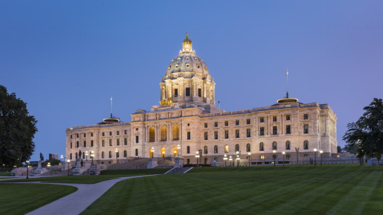
₋The Minnesota State Capitol is the seat of government for the U.S. state of Minnesota, in its capital city of Saint Paul. It houses the Minnesota Senate, Minnesota House of Representatives, the office of the Attorney General and the office of the Governor. The building also includes a chamber for the Minnesota Supreme Court, although court activities usually take place in the neighboring Minnesota Judicial Center.
₋The building is set in a landscaped campus. Various monuments are to its sides and front. Behind, a bridge spans University Avenue, and in front others were later added over the sunken roadway of Interstate 94, thus preserving the sight lines. Set near the crest of a hill, from the Capitol steps a panoramic view of downtown Saint Paul is presented.
₋Address: 75 Rev Dr Martin Luther King Jr Boulevard., St Paul, MN 55155, United States
₋Opened: January 2, 1905
₋Website: https://www.mnhs.org/capitol
2.Minnehaha Falls
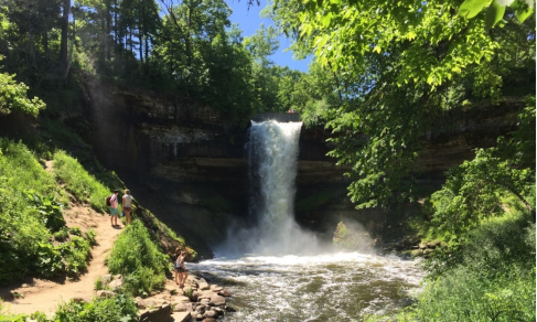
₋Minnehaha Park is a city park in Minneapolis, Minnesota, United States, and home to Minnehaha Falls and the lower reaches of Minnehaha Creek. Officially named Minnehaha Regional Park, it is part of the Minneapolis Park and Recreation Board system and lies within the Mississippi National River and Recreation Area, a unit of the National Park Service. The park was designed by landscape architect Horace W.S. Cleveland in 1883 as part of the Grand Rounds Scenic Byway system, and was part of the popular steamboat Upper Mississippi River "Fashionable Tour" in the 1800s.
₋The park preserves historic sites that illustrate transportation, pioneering, and architectural themes. Preserved structures include the Minnehaha Princess Station, a Victorian train depot built in the 1870s; the John H. Stevens House, built in 1849 and moved to the park from its original location in 1896, utilizing horses and 10,000 school children; and the Longfellow House, a house built to resemble the Henry Wadsworth Longfellow's house in Cambridge, Massachusetts. The park was listed on the National Register of Historic Places in 1969 as the Minnehaha Historic District in recognition of its state-level significance in architecture, commerce, conservation, literature, transportation, and urban planning.
₋The central feature of the park, Minnehaha Falls, was a favorite subject of pioneer photographers, beginning with Alexander Hesler's daguerreotype in 1852. Although he never visited the park, Henry Wadsworth Longfellow helped to spread the waterfall's fame when he wrote his celebrated poem, The Song of Hiawatha. The falls are located on Minnehaha Creek near the creek's confluence with the Mississippi River, near Fort Snelling. The main Minnesota Veterans Home is located on a bluff where the Mississippi and Minnehaha Creek converge. More than 850,000 people visit Minnehaha Falls each year, and it continues to be the most photographed site in Minnesota.
₋Location: Roughly Hiawatha and Minnehaha Aves, and Godfrey Rd., Minneapolis, Minnesota
₋Year built: 1849
₋Added to NRHP: November 25, 1969
₋Website: https://www.minneapolisparks.org/parks__destinations/parks__lakes/minnehaha_regional_park/
3. Como Park Zoo and Marjorie McNeely Conservatory
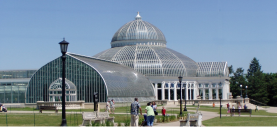
₋The Como Park Zoo and Marjorie McNeely Conservatory (or just Como Zoo and Conservatory) are located in Como Park at 1225 Estabrook Drive, Saint Paul, Minnesota. The park, zoo and conservatory are owned by the City of Saint Paul and are a division of Saint Paul Parks and Recreation. Its attractions include the zoo, the conservatory, an amusement park, a carousel, Lake Como, a golf course, a pool and more. The park receives more than 1.9 million visitors annually. Como Park is a free park and while no admission fee is charged for the zoo or conservatory, voluntary donations of $3 per adult and $2 child are suggested.
₋Address: 1225 Estabrook Dr, St Paul, MN 55103, United States
₋Opened: 1897
₋Website: https://comozooconservatory.org/
VI.History
₋Burial mounds in present-day Indian Mounds Park suggest that the area was originally inhabited by the Hopewell Native Americans about two thousand years ago. From the early 17th century until 1837, the Mdewakanton Dakota, a tribe of the Sioux, lived near the mounds after fleeing their ancestral home of Mille Lacs Lake from advancing Ojibwe. They called the area I-mni-za ska dan ("little white rock") for its exposed white sandstone cliffs. In the Menominee language it is called Sāēnepān-Menīkān, which means "ribbon, silk or satin village", suggesting its role in trade throughout the region after the introduction of European goods.
₋Following the Louisiana Purchase in 1803, US Army officer Zebulon Pike negotiated approximately 100,000 acres (40,000 ha; 160 sq mi) of land from the local Dakota tribes in 1805 to establish a fort. The negotiated territory was located on both banks of the Mississippi River, starting from Saint Anthony Falls in present-day Minneapolis, to its confluence with the Saint Croix River. Fort Snelling was built on the territory in 1819 at the confluence of the Mississippi and Minnesota rivers, which formed a natural barrier to both Native American nations. The 1837 Treaty with the Sioux ceded all local tribal land east of the Mississippi to the U.S. Government. Taoyateduta (Chief Little Crow V) moved his band at Kaposia across the river to the south. Fur traders, explorers, and missionaries came to the area for the fort's protection. Many of the settlers were French-Canadians who lived nearby. However, as a whiskey trade flourished, military officers banned settlers from the fort-controlled lands. Pierre "Pig's Eye" Parrant, a retired fur trader-turned-bootlegger who particularly irritated officials, set up his tavern, the Pig's Eye, near present-day Lambert's Landing. By the early 1840s, the community had become important as a trading center and a destination for settlers heading west. Locals called the area Pig's Eye (French: L'Œil du Cochon) or Pig's Eye Landing after Parrant's popular tavern.
₋In 1841, Father Lucien Galtier was sent to minister to the Catholic French Canadians and established a chapel, named for his favorite saint, Paul the Apostle, on the bluffs above Lambert's Landing. Galtier intended for the settlement to adopt the name Saint Paul in honor of the new chapel. In 1847, a New York educator named Harriet Bishop moved to the area and opened the city's first school. The Minnesota Territory was formalized in 1849 and Saint Paul named as its capital. In 1857, the territorial legislature voted to move the capital to Saint Peter. However, Joe Rolette, a territorial legislator, stole the physical text of the approved bill and went into hiding, thus preventing the move. On May 11, 1858, Minnesota was admitted to the union as the thirty-second state, with Saint Paul as the capital.
₋That year, more than 1,000 steamboats were in service at Saint Paul, making the city a gateway for settlers to the Minnesota frontier or Dakota Territory. Natural geography was a primary reason that the city became a landing. The area was the last accessible point to unload boats coming upriver due to the Mississippi River Valley's stone bluffs. During this period, Saint Paul was called "The Last City of the East." Industrialist James J. Hill constructed and expanded his network of railways into the Great Northern Railway and Northern Pacific Railway, which were headquartered in Saint Paul. Today they are collectively part of the BNSF Railway.
₋On August 20, 1904, severe thunderstorms and tornadoes damaged hundreds of downtown buildings, causing USD $1.78 million ($50.65 million present-day) in damages to the city and ripping spans from the High Bridge. In the 1960s, during urban renewal, Saint Paul razed western neighborhoods close to downtown. The city also contended with the creation of the interstate freeway system in a fully built landscape. From 1959 to 1961, the western Rondo Neighborhood was demolished by the construction of Interstate 94, which brought attention to racial segregation and unequal housing in northern cities. The annual Rondo Days celebration commemorates the African American community.
₋Downtown had short skyscraper-building booms beginning in the 1970s. The tallest buildings, such as Galtier Plaza (Jackson and Sibley Towers), The Pointe of Saint Paul condominiums, and the city's tallest building, Wells Fargo Place (formerly Minnesota World Trade Center), were constructed in the late 1980s. In the 1990s and 2000s, the tradition of bringing new immigrant groups to the city continued. As of 2004, nearly 10% of the city's population were recent Hmong immigrants from Vietnam, Laos, Cambodia, Thailand, and Myanmar. Saint Paul is the location of the Hmong Archives.
VII.Other Information
₋Infrastructure
₋Residents use Interstate 35E running north–south and Interstate 94 running east–west. Trunk highways include U.S. Highway 52, Minnesota State Highway 280, and Minnesota State Highway 5. Saint Paul has several unique roads such as Ayd Mill Road, Phalen Boulevard and Shepard Road/Warner Road, which diagonally follow particular geographic features in the city. Biking is also gaining popularity, due to the creation of more paved bike lanes that connect to other bike routes throughout the metropolitan area and the creation of Nice Ride Minnesota, a seasonally operated nonprofit bicycle sharing and rental system that has over 1,550 bicycles and 170 stations in both Minneapolis and Saint Paul. Downtown Saint Paul has a five-mile (8 km) enclosed skyway system over twenty-five city blocks. The 563-mile (906 km) Avenue of the Saints connects Saint Paul with Saint Louis, Missouri.
₋The layout of city streets and roads has often drawn complaints. While he was Governor of Minnesota, Jesse Ventura appeared on the Late Show with David Letterman, and remarked that the streets were designed by "drunken Irishmen". He later apologized, though people had been complaining about the fractured grid system for more than a century by that point. Some of the city's road design is the result of the curve of the Mississippi River, hilly topography, conflicts between developers of different neighborhoods in the early city, and grand plans only half-realized. Outside of downtown, the roads are less confusing, but most roads are named, rather than numbered, increasing the difficulty for non-natives to navigate.
₋Mass transit
₋Metro Transit provides bus service and light rail in the Minneapolis–Saint Paul area. The METRO Green Line is an 11-mile (18 km) light rail line that connects downtown Saint Paul to downtown Minneapolis with 14 stations in Saint Paul. The Green Line runs west along University Avenue, through the University of Minnesota campus, until it links up and then shares stations with the METRO Blue Line in downtown Minneapolis. Construction began in November 2010 and the line began service on June 14, 2014. Roughly 45,000 people rode on the first day; an average 28,000 riders are expected per day.
₋Metro Transit opened the METRO A Line, Minneapolis–Saint Paul's first arterial bus rapid transit line, along Snelling Avenue and Ford Parkway. The A Line connects the METRO Blue Line at 46th Street station to Rosedale Center with a connection at the Green Line Snelling Avenue station. The A Line is the first in a series of planned arterial bus rapid transit lines and is set to open in early 2016.
₋Railroad
₋Amtrak's Empire Builder between Chicago and Seattle stops twice daily in each direction at the newly renovated Saint Paul Union Depot. Ridership on the train increased about 6% from 2005 to over 505,000 in fiscal year 2007. A Minnesota Department of Transportation study found that increased daily service to Chicago should be economically viable, especially if it originates in Saint Paul and does not experience delays from the rest of the western route of the Empire Builder. Saint Paul is the site of the Pig's Eye Yard, a major freight classification yard for Canadian Pacific Railway. As of 2003, the yard handled over 1,000 freight cars per day. Both Union Pacific and Burlington Northern Santa Fe run trains through the yard, though they are not classified at Pig's Eye. Burlington Northern Santa Fe operates the large Northtown Yard in Minneapolis, which handles about 600 cars per day. There are several other small yards located around the city.
₋Airports
₋Saint Paul is served by the Minneapolis–Saint Paul International Airport (MSP), which sits on 3,400 acres (14 km2) southwest of the city on the west side of the Mississippi River between Minnesota State Highway 5, Interstate 494, Minnesota State Highway 77, and Minnesota State Highway 62. The airport serves three international, twelve domestic, seven charter, and four regional carriers and is a hub and home base for Delta Air Lines, Mesaba Airlines and Sun Country Airlines. Saint Paul is also served by the St. Paul Downtown Airport located just south of downtown, across the Mississippi River. The airport, also known as Holman Field, is a reliever airport run by the Metropolitan Airports Commission. The airport houses Minnesota's Air National Guard and is tailored to local corporate aviation. There are three runways that serve about 100 resident aircraft and a flight training school. The Holman Field Administration Building and Riverside Hangar are on the National Register of Historic Places.
VIII.Contact Information
Government
Mayor: Melvin Carter (DFL)
Body: Saint Paul City Council
City Hall
Phone: 651-266-6600
Email: businessresources@ci.stpaul.mn.us
Website: https://www.stpaul.gov/businesses/open-business/contact-us
