Lowell, Massachusetts 作者: 来源: 发布时间:2021-11-08
I.Population and Area
₋Area
Land: 13.8 sq mi (35.7 km2)
₋Population
Total: 106,519
Density: 8,090/sq mi (3,120/km2)
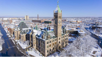
II.Natural Geography
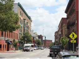
Street View
₋Lowell is a city in the U.S. Commonwealth of Massachusetts. Located in Middlesex County, Lowell (along with Cambridge) was a county seat until Massachusetts disbanded county government in 1999. With an estimated population of 110,997 in 2019, it was the fourth-largest city in Massac husetts as of the last census and is estimated to be the fifth-largest as of 2018, and the second-largest in the Boston metropolitan statistical area. The city is also part of a smaller Massachusetts statistical area called Greater Lowell, as well as New England's Merrimack Valley region.
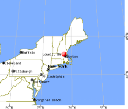
Incorporated in 1826 to serve as a mill town, Lowell was named after Francis Cabot Lowell, a local figure in the Industrial Revolution. The city became known as the cradle of the American Industrial Revolution, due to a large series of textile mills and factories. Many of the Lowell's historic manufacturing sites were later preserved by the National Park Service to create Lowell National Historical Park. During the Cambodian genocide, the city took in an influx of refugees, leading to a Cambodia Town and America's second-largest Cambodian-American population.
₋Lowell is home to two institutions of higher education.
III.ECONOMY
₋Population Density: According to the 2010 Census, there were 106,519 people living in the city. The population density was 7,842.1 people per square mile (2,948.8/km²). There were 41,431 housing units at an average density of 2,865.5 per square mile (1,106.7/km²).
₋Household Size: 2010, there were 38,470 households, and 23,707 families living in Lowell; the average household size was 2.66 and the average family size was 3.31. Of those households, 34.9% had children under the age of 18 living with them, 35.9% were married couples living together, 14.7% had a female householder with no husband present, 38.4% were non-families, 29.4% of all households were made up of individuals, and 8.3% had someone living alone who was 65 years of age or older.
₋Age Distributions: Lowell has also experienced a significant increase in the number of residents between the ages of 50-69 while the percentages of residents under the age of 15 and over the age of 70 decreased. In 2010 the city's population had a median age of 32.6. The age distribution was 23.7% of the population under the age of 18, 13.5% from 18 to 24, 29.4% from 25 to 44, 23.3% from 45 to 64, and 10.1% who were 65 years of age or older. For every 100 females, there were 98.6 males; while for every 100 females age 18 and over, there were 97.6 males.
₋Median Income: for a household in the city was $51,714, according to the American Community Survey 5-year estimate ending in 2012. The median income for a family was $55,852. Males had a median income of $44,739 versus $35,472 for females. The per capita income for the city was $22,730. About 15.2% of families and 17.5% of individuals were below the poverty line, including 24.5% of those under age 18 and 13.2% of those age 65 or over.
₋Racial Makeup: In 2010, the ethnic diversity of the city was 60.3% White (49.3% Non-Hispanic White[36]), 20.2% Asian American (12.5% Cambodian, 2.0% Indian, 1.7% Vietnamese, 1.4% Laotian), 6.8% African American, 0.3% Native American, 8.8% from other races, 3.6% from two or more races. Hispanic or Latino of any race were 17.3% of the population. The largest Hispanic group was those of Puerto Rican ancestry, comprising 11.3% of the population.
IV.Industrial Characteristics
₋By 1917, only about twenty per cent of the population were native-born Americans with native parents. THROUGH NORMALCY AND DEPRESSION.-- Lowell's industries boomed during World War I and for several years afterwards. A textile depression set in after 1923, and Lowell was seriously affected. The old Hamilton Company liquidated in 1926; and in the following years many of the other companies liquidated, sold out, moved out of the city, or ceased operation. When the general depression gripped the city after 1929, many of Lowell's buildings were demolished for tax purposes. The woolen and worsted industry replaced cotton as the city's most important industry, and several shoe companies became very important to Lowell's economy. During this period, many small companies located in Lowell. These concerns laid the foundation for the city's diversification of industry. The many small companies were not enough to utilize all of the space or manpower left idle by the older firms. THE CITY OF DIVERSIFIED INDUSTRIES.-- Lowell boomed during World War, as most of the companies produced war goods. With the end of the war, Lowell suffered again from a large surplus of labor. The Korean War did little to relieve the unemployment situation. Though the war caused considerable price inflation, the textile industry went into another depression. Since the formation of the Lowell Industrial and Development Commission in 1952, there has been a vigorous and organized attempt to attract producers of durable goods like electronics equipment, rather than makers of nondurable goods like textiles. Through more diverse industries, the commission hopes to bring about a more stable city economy. Though the city has done much to improve itself, it will need legislative help from the state and federal governments before it can make itself very attractive to prospective new industries.
₋Website: https://open.bu.edu/handle/2144/8105
V.Attractions
1.Lowell National Historical Park
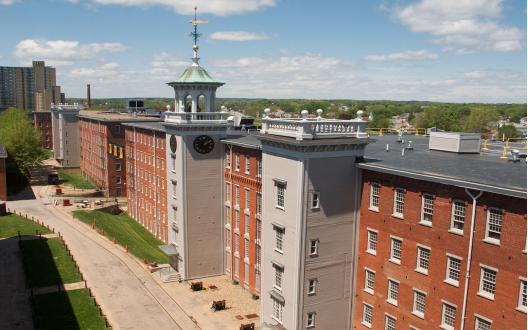
₋Lowell National Historical Park is a National Historical Park of the United States located in Lowell, Massachusetts. Established in 1978 a few years after Lowell Heritage State Park, it is operated by the National Park Service and comprises a group of different sites in and around the city of Lowell related to the era of textile manufacturing in the city during the Industrial Revolution. In 2019, the park was included as Massachusetts' representative in the America the Beautiful Quarters series.
₋First settled by Europeans in the 17th century, East Chelmsford (later renamed Lowell in honor of the founders' deceased business partner) became an important manufacturing center along the Merrimack River in the early 1820s. It was seen as an attractive site for the construction of a planned industrial city, with the Middlesex Canal (completed in 1803) linking the Merrimack to the Charles River, which flows through Boston, and with the powerful 32' Pawtucket Falls. The already existent Pawtucket Canal, designed for transportation around the Pawtucket Falls on the Merrimack, became the feeder canal for a 5.6-mile long system of power canals based around the falls. Unlike many other mill towns, however, Lowell's manufacturing facilities were built based on a planned community design. Specifically Lowell was planned as reaction to the mill communities in Great Britain, which were perceived as cramped and inhumane. Some called it the "Lowell Experiment," which was an attempt at creating a manufacturing center with a combination of production efficiency with democratic morals and social structure.
₋Initially the factories of Lowell were built with ample green space and accompanying clean dormitories, in a style that anticipated such later architectural trends as the City Beautiful movement in the 1890s. Lowell attracted both immigrants from abroad and migrants from within New England and Quebec (including a large proportion of young women, known as Lowell mill girls) who lived in the dormitories and worked in the mills.
₋The textile industry in New England experienced a sharp decline after World War II and by the 1960s, many of the Lowell's textile mill buildings were abandoned. In the late 1960s and early 1970s, several important forces came together from which emerged the Lowell National Historical Park. Congressman F. Bradford Morse assisted in the city's selection for "Model Cities" status; Brendan Fleming, UMass Lowell (UML) Math Department faculty member, after his election to the Lowell City Council proposed the first Historic District "The Mill and Canal District" which was approved in 1972; Gordon Marker, Executive Director of Model Cities and an urban planner, was instrumental in designing the concept for an Urban Park based on Historic Preservation and Economic Revitalization; Patrick Mogan, Education Administrator and later Superintendent of Schools, was primarily interested in Lowell's children and strongly advocated the preservation and sharing of their cultural experiences; and the Lowell Historical Society which opened the Lowell Museum in 1976. Together these circles of interest became a collaborating force led by United States Senator and Lowell native Paul Tsongas to enact legislation for a national park. In 1978, the United States Congress established the Lowell National Historical Park, the Lowell Historic Preservation District, and the Lowell Historic Preservation Commission.
₋In 1990, The Trust for Public Land assisted the National Park Service in acquiring 3 acres for the purpose of housing the headquarters for the Lowell National Historical Park
₋Address: 67 Kirk St, Lowell, MA 01852, United States
₋Website: https://www.nps.gov/lowe/planyourvisit/index.htm
2.Lowell Cemetery
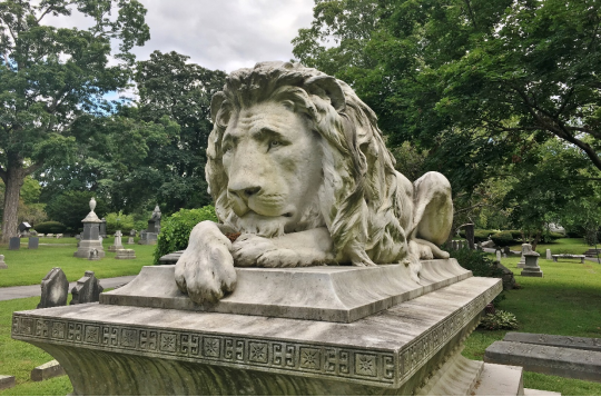
₋Lowell Cemetery is a cemetery located in Lowell, Massachusetts. Founded in 1841 and located on the banks of the Concord River, the cemetery is one of the oldest garden cemeteries in the nation, inspired by Mount Auburn Cemetery in Cambridge, Massachusetts. Many of Lowell's wealthy industrialists are buried here, under ornate Victorian tombstones. A 73-acre (30 ha) portion of the 84 acres (34 ha) cemetery was listed on the National Register of Historic Places in 1998.
₋The cemetery is located in the central eastern part of the city, roughly bounded on the north by Fort Hill Park, on the east by Shedd Park, on the south by railroad tracks, and on the west by the Concord River, from which it is separated by Lawrence Street, where its historic main gate is located. It occupies 84 acres of rolling terrain, much of which has been developed. The main gate is a monumental granite structure designed by C. W. Painter and built in 1862. There is a secondary gate on Knapp Avenue at the cemetery's northeast corner, which was added in 1905. There are two buildings in the cemetery: the Talbot Memorial Chapel (1885) and the Superintendent's Office (1887), both Gothic Revival structures designed by Boston architect Frederick Stickney.
₋Roadways in the cemetery were laid out to take advantage of the natural terrain, occasionally providing vistas. The main circulation route, Washington Avenue, roughly encircles the property, with several roads providing access across the central areas. The cemetery was laid out in 1841 to a design by George P. Worcester, a civil engineer, applying principles of the rural cemetery movement that was then just coming into vogue. The cemetery has a wide variety of funerary art in diverse styles, from typical Victorian forms to the Egyptian Revival and Art Deco. Many prominent Lowell residents of the 19th and 20th centuries are interred here.
₋Address: 77 Knapp Ave, Lowell, MA 01852, United States
₋Phone: +1 978-454-5191
₋Website: https://www.lowellcemetery.com/
3. Whistler House Museum of Art
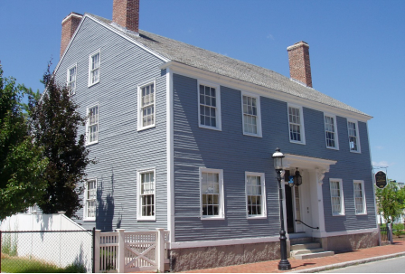
₋The Whistler House Museum of Art is the birthplace of painter and etcher James McNeill Whistler. It is located at 243 Worthen Street, Lowell, Massachusetts, USA, and is open as a museum displaying works from the museum collection and shows by artist members.
₋The house was built in 1823 by the Locks and Canals Company for their manager. Paul Moody, master mechanic and inventor, was the first resident of the house. Upon becoming Chief Engineer in 1834, George Washington Whistler lived in the house with his wife, Anna Matilda McNeill Whistler. Their son James Whistler was born in 1834 there. James B. Francis took over as chief engineer and moved into the house in 1837 when G.W. Whistler moved to Russia. James Francis married Sarah, and they raised their six children here.
₋In 1907 the home was purchased by the Lowell Art Association, Inc., and opened in 1908 as a museum.
₋Address: 243 Worthen St, Lowell, MA 01852, United States
₋Opened: 1823
₋Phone: +1 978-452-7641
₋Website: https://www.whistlerhouse.org/
VI.History
₋Founded in the 1820s as a planned manufacturing center for textiles, Lowell is located along the rapids of the Merrimack River, 25 miles northwest of Boston in what was once the farming community of East Chelmsford, Massachusetts. The so-called Boston Associates, including Nathan Appleton and Patrick Tracy Jackson of the Boston Manufacturing Company, named the new mill town after their visionary leader, Francis Cabot Lowell, who had died five years before its 1823 incorporation. As Lowell's population grew, it acquired land from neighboring towns, and diversified into a full-fledged urban center. Many of the men who composed the labor force for constructing the canals and factories had immigrated from Ireland, escaping the poverty and Potato Famines of the 1830s and 1840s. The mill workers, young single women called Mill Girls, generally came from the farm families of New England.
₋By the 1850s, Lowell had the largest industrial complex in the United States. The textile industry wove cotton produced in the South. In 1860, there were more cotton spindles in Lowell than in all eleven states combined that would form the Confederacy.[8] Yet the city did not simply finish raw materials produced in the American South, but rather became involved in the South in another way, too. Many of the coarse cottons produced in Lowell eventually returned to the South to clothe enslaved people, and, according to historian Sven Beckert, "'Lowell' became the generic term slaves used to describe coarse cottons." The city continued to thrive as a major industrial center during the 19th century, attracting more migrant workers and immigrants to its mills. Next were the Catholic Germans, followed by a large influx of French Canadians during the 1870s and 1880s. Later waves of immigrants came to work in Lowell and settled in ethnic neighborhoods, with the city's population reaching almost 50% foreign-born by 1900. By the time World War I broke out in Europe, the city had reached its economic and population peak of over 110,000 people.
₋The Mill Cities' manufacturing base declined as companies began to relocate to the South in the 1920s. The city fell into hard times, and was even referred to as a "depressed industrial desert" by Harper's Magazine in 1931, as the Great Depression worsened. At this time, more than one-third of its population was "on relief", as only three of its major textile corporations remained active. Several years later, the mills were reactivated, making parachutes and other military necessities for the World War II effort. However, this economic boost was short-lived and the post-war years saw the last textile plants close.
₋Zoning, development and the Massachusetts Miracle
₋In the 1970s, Lowell became part of the Massachusetts Miracle, being the headquarters of Wang Laboratories. At the same time, Lowell became home to thousands of new immigrants, many from Cambodia, following the genocide at the hands of the Khmer Rouge. The city continued to rebound, but this time, focusing more on culture. The former mill district along the river was partially restored and became part of the Lowell National Historical Park, founded in the late 1970s.
₋Although Wang went bankrupt in 1992, the city continued its cultural focus by hosting the nation's largest free folk festival, the Lowell Folk Festival, as well as many other cultural events. This effort began to attract other companies and families back to the urban center. Additional historic manufacturing and commercial buildings were adapted as residential units and office space. By the 1990s, Lowell had built a new ballpark and arena, which became home to two minor league sports teams, the Lowell Devils and Lowell Spinners. The city also began to have a larger student population. The University of Massachusetts Lowell and Middlesex Community College expanded their programs and enrollment. During the period of time when Lowell was part of the Massachusetts Miracle, the Lowell City Development Authority created a Comprehensive Master Plan which included recommendations for zoning adaptations within the city. The city's original zoning code was adopted in 1926 and was significantly revised in 1966 and 2004, with changes included to respond to concerns about overdevelopment.
₋In 2002, in lieu of updating the Comprehensive Master Plan, more broad changes were recommended so that the land use and development would be consistent with the current master plan. The most significant revision to the 1966 zoning code is the adoption of an inclusion of a transect-based zoning code and some aspects of a form-based code style of zoning that emphasizes urban design elements as a means to ensure that infill development will respect the character of the neighborhood or district in question. By 2004, the recommended zoning changes were unanimously adopted by the City Council and despite numerous changes to the 2004 Zoning Code, it remains the basic framework for resolving zoning issues in Lowell to this day.
₋The Hamilton Canal District (HCD) is the first district in Lowell in which regulation and development is defined by Form-Based Code (HCD-FBC) and legislated by its own guiding framework consistent to the HCD Master Plan.[13] The HCD is a major redevelopment project that comprises 13-acres of vacant, underutilized land in downtown Lowell abutting former industrial mills. Trinity Financial was elected as the Master Developer to recreate this district with a vision of making a mixed-use neighborhood. Development plans included establishing the HCD as a gateway to downtown Lowell and enhanced connectivity to Gallagher Terminal.
VII.Other Information
₋Transportation
₋Lowell can be reached by automobile from Interstate 495, U.S. Route 3, the Lowell Connector, and Massachusetts Routes: 3A, 38, 110, 113, and 133, all of which run through the city; Route 133 begins at the spot where Routes 110 and 38 branch off just south of the Merrimack River. There are six bridges crossing the Merrimack River in Lowell, and four crossing the Concord River (not including the two for I-495).
₋For public transit, Lowell is served by the Lowell Regional Transit Authority (LRTA), which provides fixed route bus services and paratransit services to the city and surrounding area. OurBus has daily bus service to Worcester and New York City. Other service includes Merrimack Vallery Regional Transfer Authority (MVRTA) Route 41 to Lawrence, and the Coach Company bus to Foxwoods Resort Casino.
₋Lowell is also served by the MBTA's commuter rail Lowell Line, with several departures daily to and from Boston's North Station.
₋The Lowell National Historical Park provides a free streetcar shuttle between its various sites in the city center, using track formerly used to provide freight access to the city's mills. An expansion to expand the system to 6.9 miles was planned but rejected in 2016.
₋In addition to several car rental agencies, Lowell has four (4) Zipcar rental locations convenient to Gallagher Terminal, the Downtown, and the three (3) UMass Lowell campuses (North, South and East).
VIII.Contact Information
Government
Type: Manager-City council
Mayor: John Leahy
City Manager: Eileen Donoghue
City Hall
Address:
375 Merrimack Street
Lowell, MA 01852
Phone: 978-674-4000
Website: https://www.lowellma.gov/142/Contact
