Baton Rouge, Louisiana 作者: 来源: 发布时间:2021-11-05
I.Population and Area
₋Area
Land: 85.93 sq mi (222.55 km2)
₋Population
Total: 229,493
Density: 2,650.13/sq mi (1,023.22/km2)
II.Natural Geography
Overview
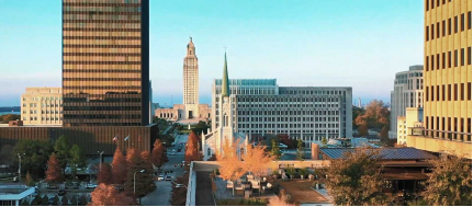
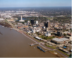
₋Baton Rouge is the capital of the U.S. state of Louisiana. Located on the eastern bank of the Mississippi River, it is the parish seat of East Baton Rouge Parish, the most populous parish in Louisiana. It is the 100th most populous city in the United States, and second-largest city in Louisiana after New Orleans. It is also the 16th most populous state capital. As of the U.S. Census Bureau's July 2019 estimate, Baton Rouge had a population of 220,236, down from 229,493 at the 2010 census. Baton Rouge is the center of Greater Baton Rouge, the second-largest metropolitan area in Louisiana, with a population of 834,159 as of 2017, up from 802,484 in 2010 and 829,719 in 2015.
₋The city of Baton Rouge is a major industrial, petrochemical, medical, research, motion picture, and growing technology center of the American South. It is the location of Louisiana State University, the LSU System's flagship university and the largest institution of higher education in the state. It is also the location of Southern University, the flagship institution of the Southern University System, the only historically black college system in the nation. The Port of Greater Baton Rouge is the 10th-largest in the United States in terms of tonnage shipped, and is the farthest upstream Mississippi River port capable of handling Panamax ships. This, as well as its status as a major port city, is largely due to the Huey P. Long - O.K. Allen Bridge, which was intentionally constructed under the governorship of Huey Long at a low height, preventing big tankers from making their way up-river, past Baton Rouge.
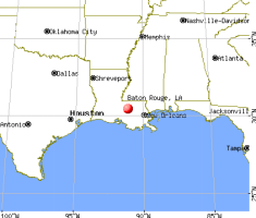
₋The Baton Rouge area owes its historical importance to its strategic site upon the Istrouma Bluff, the first natural bluff upriver from the Mississippi River Delta at the Gulf of Mexico. This allowed development of a business quarter safe from seasonal flooding. In addition, the city built a levee system stretching from the bluff southward to protect the riverfront and low-lying agricultural areas. The city is a culturally rich center, with settlement by immigrants from numerous European nations and African peoples brought to North America as slaves or indentured servants. It was ruled by seven different governments: French, British, and Spanish in the colonial era; the Republic of West Florida, as a United States territory and state, Confederate, and United States again since the end of the American Civil War.
III.ECONOMY
₋The average salary in Baton Rouge, LA is $58k. Trends in wages decreased by -2.2 percent in Q1 2020. The cost of living in Baton Rouge, LA is 4 percent higher than the national average. The most popular occupations in Baton Rouge, LA are Project Manager, (Unspecified Type / General), Operations Manager, and Human Resources (HR) Manager which pay between $35k and $109k per year. The most popular employers in Baton Rouge, LA are Louisiana State University (LSU), Blue Cross and Blue Shield of Louisiana, and Our Lady of The Lake Hospital.
₋Website: https://www.payscale.com/research/US/Location=Baton-Rouge-LA/Salary
IV.Industrial Characteristics
₋Baton Rouge enjoys a strong economy that has helped the city be ranked as one of the "Top 10 Places for Young Adults" in 2010 by portfolio.com and one of the top 20 cities in North America for economic strength by the Brookings Institution. In 2009, the city was ranked by CNN as the 9th-best place in the country to start a new business. Lamar Advertising Company has its headquarters in Baton Rouge.
₋Baton Rouge is the furthest inland port on the Mississippi River that can accommodate ocean-going tankers and cargo carriers. The ships transfer their cargo (grain, oil, cars, containers) at Baton Rouge onto rails and pipelines (to travel east–west) or barges (to travel north). Deep-draft vessels cannot pass the Old Huey Long Bridge because the clearance is insufficient. In addition, the river depth decreases significantly just to the north, near Port Hudson.
₋Baton Rouge's largest industry is petrochemical production and manufacturing. ExxonMobil's Baton Rouge Refinery complex is the fourth-largest oil refinery in the country; it is the world's 10th largest. Baton Rouge also has rail, highway, pipeline, and deep-water access.
₋Dow Chemical Company has a large plant in Iberville Parish near Plaquemine, 17 miles (27 km) south of Baton Rouge. Shaw Construction, Turner, and Harmony all started with performing construction work at these plants.
₋In addition to being the state capital and parish seat, the city is the home of Louisiana State University, which employs over 5,000 academic staff. One of the largest single employers in Baton Rouge is the state government, which consolidated all branches of state government downtown at the Capitol Park complex.
₋The city has a substantial medical research and clinical presence. Research hospitals have included Our Lady of the Lake, Our Lady of the Lake Children's Hospital (affiliated with St. Jude Children's Research Hospital), Mary Bird Perkins Cancer Center, and Earl K. Long (closed 2013). Together with an emerging medical corridor at Essen Lane, Summa Avenue and Bluebonnet Boulevard, Baton Rouge is developing a medical district expected to be similar to the Texas Medical Center. LSU and Tulane University have both announced plans to construct satellite medical campuses in Baton Rouge to partner with Our Lady of the Lake Medical Center and Baton Rouge General Medical Center, respectively.
₋Southeastern Louisiana University and Franciscan Missionaries of Our Lady University both have nursing schools in the medical district off Essen Lane. Louisiana State University's Pennington Biomedical Research Center, which conducts clinical and biological research, also contributes to research-related employment in the area around the Baton Rouge medical district.
₋The film industry in Louisiana has increased dramatically since the beginning of the 21st century, aided by generous tax incentives adopted by the state in 2002. In September 2013, the Baton Rouge Film Commission reported that the industry had brought more than $90 million into the local economy in 2013. Baton Rouge's largest production facility is the Celtic Media Centre, opened in 2006 by a local group in collaboration with Raleigh Studios of Los Angeles. Raleigh dropped its involvement in 2014.
V.Attractions
1.Old Louisiana State Capitol
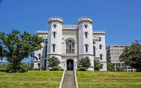
₋The Old Louisiana State Capitol, also known as the State House, is a historic government building, and now a museum, at 100 North Boulevard in Baton Rouge, Louisiana, U.S.A.. It housed the Louisiana State Legislature from the mid-19th century until the current capitol tower building was constructed in 1929-32.
₋It was built to both look like and function like a castle and has led some locals to call it the Louisiana Castle, the Castle of Baton Rouge, the Castle on the River, or the Museum of Political History; although most people just call it the old capitol building. The term "Old State Capitol" in Louisiana is used to refer to the building and not to the two towns that were formerly the capital city: New Orleans and Donaldsonville.
₋The building was added to the National Register of Historic Places on January 12, 1973, and was designated a National Historic Landmark on May 30, 1974.
₋Address: 100 North Blvd, Baton Rouge, LA 70801, United States
₋Phone: +1 225-342-0500
₋Website: https://louisianaoldstatecapitol.org/
2.USS Kidd (DD-661)
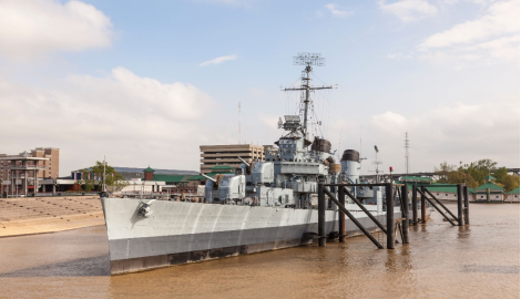
₋USS Kidd (DD-661), a Fletcher-class destroyer, was the first ship of the United States Navy to be named after Rear Admiral Isaac C. Kidd, who died on the bridge of his flagship USS Arizona during the 1941 Japanese attack on Pearl Harbor. Admiral Kidd was the first US flag officer to die during World War II, and the first American admiral ever to be killed in action. A National Historic Landmark, she is now a museum ship, berthed on the Mississippi River in Baton Rouge, Louisiana, and is the only surviving US destroyer still in her World War II configuration.
₋Kidd (DD-661) was launched on 28 February 1943 by Federal Shipbuilding & Drydock Co., Kearny, New Jersey, sponsored by Mrs. Isaac C. Kidd, widow of Rear Admiral Kidd. The destroyer was commissioned on 23 April 1943, Commander Allan Roby in command. During her initial cruise to the Brooklyn Naval Shipyards, she sailed across New York Harbor with the Jolly Roger flying from the foremast. Subsequently, during outfitting, her crew adopted the pirate captain William Kidd as their mascot, and commissioned a local artist to paint a pirate figure on the forward smokestack.
₋After shakedown out of Casco Bay, Maine in June, Kidd cruised in the Atlantic and Caribbean escorting large combatant vessels until she departed for the Pacific in August 1943 in company with the battleships Alabama and South Dakota. Arriving at Pearl Harbor on 17 September 1943, she got underway on 29 September escorting aircraft carriers toward Wake Island for the heavy air attacks conducted on October 6 on Japanese installations located there, returning to Pearl Harbor on October 11, 1943.
₋Mid-October Kidd was underway with a task force to strike Rabaul and support the Bougainville landings. Upon reaching a strike position south of Rabaul on the morning of 11 November, the task force launched attacks upon Japanese positions on the island. Kidd was ordered to rescue the crew of an aircraft from Essex which had ditched astern of the formation. During this rescue, a group of Japanese aircraft attacked the destroyer; Kidd shot down three attacking aircraft and completed the rescue while maneuvering to dodge torpedoes and bombs. Cmdr. Roby, her commanding officer, received the Silver Star for gallantry during this action. The destroyer returned to Espiritu Santo on 13 November.
₋Kidd next screened carriers making air attacks on Tarawa during the Gilbert Islands invasion from 19 to 23 November. On 24 November, she spotted 15 low flying enemy bombers heading toward the heavy ships, gave warning, and shot down two Aichi D3A "Val" dive bombers. After Tarawa was secure, Kidd remained in the Gilbert Islands to support cleanup operations before returning to Pearl Harbor 9 December.
₋On 11 January 1944 Kidd sailed for the forward area at Espiritu Santo, then sailed the next day for Funafuti, arriving 19 January. During the invasion of the Marshall Islands 29 January to 8 February, Kidd screened heavy ships and bombarded Roi and Wotje, then anchored at Kwajalein 26 February.
₋From 20 March to 14 April, Kidd guarded an airstrip under construction on Emirau and supported the occupation of Aitape and Hollandia in New Guinea 16 April to 7 May. She fought in the Marianas campaign 10 June to 8 July, and performed shore bombardment at Guam between 8 July and 10 August.
₋In need of repairs, Kidd sailed for Pearl Harbor, arriving 26 August 1944. On 15 September, she departed Pearl, reached Eniwetok 26 September, and arrived at Manus on 3 October. There she became part of the giant Philippines invasion fleet and entered Leyte Gulf 20 October. Here, she screened the initial landings and provided fire support for soldiers who fought to reconquer the island until she sailed 14 November for Humboldt Bay, New Guinea, arriving 19 November. On 9 December Kidd headed toward Mare Island Navy Yard for overhaul and moored at Mare Island on Christmas Day.
₋Kidd sailed 19 February 1945, to join Task Force 58 (TF 58) for the invasion of Okinawa. Trained and battle wise, Kidd played a key role during the first days of the Okinawa campaign, screening battleships, bombarding shore targets, rescuing downed pilots, sinking floating mines, providing early warning of raids, guarding the heavily-damaged aircraft carrier Franklin, and helping to shoot down kamikazes.
₋While on picket station 11 April 1945, Kidd and her division mates, Black, Bullard, and Chauncey, with the help of Combat Air Patrol, repelled three air raids. That afternoon, a single enemy plane crashed into Kidd, killing 38 men and wounding 55. As the destroyer headed south to rejoin the task group, her fire drove off further enemy planes that were trying to finish her off. Stopping at Ulithi for temporary repairs, she got underway on 2 May for the West Coast, arriving at Hunter's Point Naval Shipyard on 25 May.
₋On 1 August 1945, Kidd sailed to Pearl Harbor and returned to San Diego, California 24 September 1945 for inactivation. She decommissioned 10 December 1946 and entered the Pacific Reserve Fleet.
₋Address: 305 S River Rd, Baton Rouge, LA 70802, United States
₋Construction started: October 16, 1942
₋Launched: February 28, 1943
₋Website: https://www.usskidd.com/
3.Louisiana Art & Science Museum
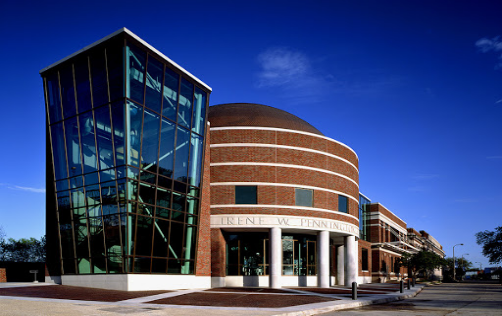
₋Baton Rouge station is a historic train station located at 100 South River Road in downtown Baton Rouge, Louisiana. The building now houses the Louisiana Art and Science Museum.
₋The two-story main block and the two one-story wings in Classical Revival style stand directly across the Old State Capitol building.
₋The building was added to the National Register of Historic Places on May 19, 1994 as the Yazoo and Mississippi Valley Railroad Co. Depot.
₋IC-333, a 0-6-0 steam engine formerly owned by the Charles Black Sand & Gravel Company of Fluker, LA, is on display just outside the building. Several passenger cars previously on display have been removed. As of 2011, IC-333 and its tender have been removed from the site as well.
₋Address: 100 S River Rd, Baton Rouge, LA 70801, United States
₋Phone: +1 225-344-5272
₋Website: https://www.lasm.org/
VI.History
₋Prehistory
₋Human habitation in the Baton Rouge area has been dated to 12000–6500 BCE, based on evidence found along the Mississippi, Comite, and Amite rivers. Earthwork mounds were built by hunter-gatherer societies in the Middle Archaic period, from roughly the fourth millennium BCE. The speakers of the Proto-Muskogean language divided into its descendant languages by about 1000 BCE; and a cultural boundary between either side of Mobile Bay and the Black Warrior River began to appear between about 1200 BCE and 500 BCE, a period called the Middle "Gulf Formational Stage". The Eastern Muskogean language began to diversify internally in the first half of the first millennium AD.
₋The early Muskogean societies were the bearers of the Mississippian culture, which formed around 800 CE and extended in a vast network across the Mississippi and Ohio valleys, with numerous chiefdoms in the Southeast, as well. By the time the Spanish made their first forays inland from the shores of the Gulf of Mexico in the early 16th century, by some evidence many political centers of the Mississippians were already in decline, or abandoned. At the time, this region appeared to have been occupied by a collection of moderately sized native chiefdoms, interspersed with autonomous villages and tribal groups. Other evidence indicates these Mississippian settlements were thriving at the time of the first Spanish contact. Later Spanish expeditions encountered the remains of groups who had lost many people and been disrupted in the aftermath of infectious diseases, chronic among Europeans, unknowingly introduced by the first expedition.
₋Colonial period
₋Further information: Louisiana (New France), West Florida, and Red Sticks
₋French explorer Pierre Le Moyne d'Iberville led an exploration party up the Mississippi River in 1698. The explorers saw a red pole marking the boundary between the Houma and Bayagoula tribal hunting grounds. The French name le bâton rouge ("the red stick") is the translation of a native term rendered as Istrouma, possibly a corruption of the Choctaw iti humma ("red pole");[17] André-Joseph Pénicaut, a carpenter traveling with d'Iberville, published the first full-length account of the expedition in 1723. According to Pénicaut,
₋From there [Manchacq] we went five leagues higher and found very high banks called écorts in that region, and in savage called Istrouma which means red stick [bâton rouge], as at this place there is a post painted red that the savages have sunk there to mark the land line between the two nations, namely: the land of the Bayagoulas which they were leaving and the land of another nation—thirty leagues upstream from the baton rouge—named the Oumas.
₋The location of the red pole was presumably at Scott's Bluff, on what is now the campus of Southern University. It was reportedly a 30-foot-high (9.1 m) painted pole adorned with fish bones.
₋The settlement of Baton Rouge by Europeans began in 1721 when French colonists established a military and trading post. Since European settlement, Baton Rouge has been governed by France, Britain, Spain, Louisiana, the Republic of West Florida, the United States, the Confederate States, and the United States again. In 1755, when French-speaking settlers of Acadia in Canada's Maritime provinces were expelled by British forces, many took up residence in rural Louisiana. Popularly known as Cajuns, the descendants of the Acadians maintained a separate culture. During the first half of the 19th century, Baton Rouge grew steadily as the result of steamboat trade and transportation.
₋Modern history
₋Baton Rouge was incorporated in 1817. In 1822, the Pentagon Barracks complex of buildings was completed. The site has been used by the Spanish, French, British, Confederate States Army, and United States Army and was part of the short-lived Republic of West Florida. In 1951, ownership of the barracks was transferred to the State of Louisiana. In 1976 the complex was listed on the National Register of Historic Places.
₋Acquisition of Louisiana by the United States in 1803 was a catalyst for increased Anglo-American settlement, especially in the northern part of the state. In 1846, the state legislature designated Baton Rouge as Louisiana's new capital to replace "sinful" New Orleans. The architect James Dakin was hired to design the capitol building in Baton Rouge, with construction beginning in late 1847. Rather than mimic the United States Capitol, as many other states had done, he designed a capitol in Neo-Gothic style, complete with turrets and crenellations, and stained glass. It overlooks the Mississippi. It has been described as the "most distinguished example of Gothic Revival" architecture in the state and has been designated as a National Historic Landmark.
₋By the outbreak of the Civil War, the population of Baton Rouge was nearly 5,500. The war nearly halted economic progress, except for businesses associated with supplying the Union Army occupation of the city, which began in the spring of 1862 and lasted for the war. The Confederates at first consolidated their forces elsewhere, during which time the state government was moved to Opelousas and later Shreveport. In the summer of 1862, about 2,600 Confederate troops under generals John C. Breckinridge (the former Vice President of the United States) and Daniel Ruggles tried in vain to recapture Baton Rouge.
₋After the war, New Orleans temporarily served as the seat of the Reconstruction era state government. When the Bourbon Democrats regained power in 1882, after considerable intimidation and voter suppression of black Republicans, they returned the state government to Baton Rouge, where it has since remained. In his 1893 guidebook, Karl Baedeker described Baton Rouge as "the Capital of Louisiana, a quaint old place with 10,378 inhabitants, on a bluff above the Mississippi".
₋In the 1950s and 1960s, the petrochemical industry had a boom in Baton Rouge, stimulating the city's expansion beyond its original center. The changing market in the oil business has produced fluctuations in the industry, affecting employment in the city and area.
₋A building boom began in the city in the 1990s and continued into the 2000s, during which Baton Rouge was one of the fastest-growing cities in the South in terms of technology. Metropolitan Baton Rouge was ranked as one of the fastest-growing metropolitan areas in the U.S. (with a population under 1 million), with 602,894 in 2000 and 802,484 people as of the 2010 census. After the extensive damage in New Orleans and along the coast from Hurricane Katrina on August 29, 2005, this city accepted as many as 200,000 displaced residents.
₋In 2010, Baton Rouge started a market push to become a test city for Google's new super high speed fiber optic line known as GeauxFiBR.
₋The Baton Rouge metropolitan area was heavily affected by the 2016 Louisiana floods in August.
₋In 2017, Christopher Manuel, an off-duty Baton Rouge police officer, crashed into an SUV while driving 94 miles per hour in a sports car, killing a 1-year-old child and causing serious injuries to an adult woman and three children. Criminal charges against the officer were dropped, and he was not charged for speeding.
VII.Other Information
₋Shipping
₋The Port of Baton Rouge is the 9th-largest in the United States in terms of tonnage shipped, and is the farthest upstream Mississippi River port capable of handling Panamax ships.
₋Highways and roads
₋Interstates
₋Baton Rouge has three interstate highways: I-10, I-12 (Republic of West Florida Parkway), and I-110 (Martin Luther King Jr. Freeway).
₋Interstate 10 enters the city from the Horace Wilkinson Bridge over the Mississippi River, curving at an interchange with Interstate 110 southeast, crossing the LSU lakes and Garden District before reaching an interchange with I-12 (referred to as the 10/12 split). It curves further southeast, towards New Orleans as it crosses Essen Lane near the Medical District. It passes Bluebonnet Blvd and the Mall of Louisiana at exit 162, and leaves Baton Rouge after interchanges with Siegen Lane and Highland Road.
₋Interstate 12 (The Republic of West Florida Parkway) begins in the city at the I-10/I-12 split east of College Drive, and goes east from there, crossing Essen Lane, Airline Hwy, Sherwood Forest Blvd, Millerville Road, and O'neal Lane before leaving the city when crossing the Amite River.
₋Interstate 110 (The Martin Luther King, Jr. Freeway) stretches 8 miles in a north–south direction from the east end of the Horace Wilkinson Bridge to Scenic Highway in Scotlandville, Louisiana. It passes through downtown, North Baton Rouge, and Baton Rouge Metro Airport before ending at Scenic Highway.
₋US highways and major roads
₋Baton Rouge has two US highways, along with their business counterparts: Airline Highway (US 61) and Florida Boulevard.
₋US 190 enters the city from the Huey P. Long Bridge, beginning a concurrency with US 61 after an interchange with Scenic Highway, near Scotlandville. Its name is Airline Highway from this interchange to the interchange with Florida Blvd. At this interchange, US 190 turns east to follow Florida Blvd through Northeast Baton Rouge, exiting the city at the Amite River.
₋US 61 enters Baton Rouge as Scenic Highway until it reaches Airline Highway (US 190). It becomes concurrent with US 190 until Florida Blvd, where it continues south, still called Airline Highway. It passes through Goodwood and Broadmoor before an interchange with I-12. It continues southeast past Bluebonnet Blvd/Coursey Blvd, Jefferson Hwy, and Sherwood Forest Blvd/Siegen Lane before exiting the city at Bayou Manchac.
₋US 61/190 Business runs west along Florida Boulevard (known as Florida Street from Downtown east to Mid City) from Airline Highway to River Road in downtown. The cosigned routes run from Florida St. north along River Road, passing the Louisiana State Capitol and Capitol Park Complex before intersecting with Choctaw Drive. North of this intersection River Road becomes Chippewa Street and curves to the East. US 61/190 Business leaves Chippewa Street at its intersection with Scenic Highway. The route follows Scenic Highway to Airline Highway, where it ends. North of Airline on Scenic and East of Scenic Highway on Airline is US 61. US 190 is East and West of Scenic on Airline Highway.
₋These are important surface streets with designated state highway numbers: Greenwell Springs Road (LA 37), Plank Road/22nd Street (LA 67), Burbank Drive/Highland Road (LA 42), Nicholson Drive (LA 30), Jefferson Highway/Government Street (LA 73), Scotlandville/Baker/Zachary Highway (LA 19), Essen Lane (LA 3064), Bluebonnet Blvd/Coursey Blvd (LA 1248), Siegen Lane (LA 3246), and Perkins Road/Acadian Thruway (LA 427).
₋Traffic issues and highway upgrades
₋According to the 2008 INRIX National Traffic Scorecard, which ranks the top 100 congested metropolitan areas in the U.S., Baton Rouge is the 33rd-most congested metro area in the country. However, at a population rank of 67 out of 100, it has the second-highest ratio of population rank to congestion rank, higher than even the Los Angeles-Long Beach-Santa Ana metropolitan area, indicating a remarkably high level of congestion for the comparatively low population. According to the Scorecard, Baton Rouge was the only area out of all 100 to show an increase in congestion from 2007 to 2008 (+ 6%). The city also tied for the highest jump in congestion rank over the same period (14 places).
₋Interstate 12 used to have a major bottleneck at O'Neal Lane. The interstate was three lanes wide in each direction to the O'Neal Lane exit, where the interstate abruptly became two lanes in each direction and crossed the narrow Amite River Bridge. This stretch of road, called "a deathtrap" by one lawmaker, had become notorious for traffic accidents, many with fatalities. In 2007, ten people died in traffic accidents within a three-month period on this section of road. Governor Bobby Jindal and the Baton Rouge legislative delegation, in 2009, were successful in allocating state and federal funding to widen I-12 from O'neal Lane to Range Avenue (Exit 10) in Denham Springs. The construction was completed in mid-2012 and has significantly improved the flow of traffic. In 2010, The American Reinvestment and Recovery Act provided committed federal funds to widen I-12 from the Range Avenue Exit to Walker, Louisiana. Noticing the significant improvement in commute times, Bobby Jindal further funded widening to Satsuma, Louisiana.
₋Interstate 10 West at Bluebonnet Road also ranked within the top 1000 bottlenecks for 2008, and I-10 East at Essen Lane and Nicholson Drive ranked not far out of the top 1000. A new exit to the Mall of Louisiana was created in 2006, and the interstate was widened between Bluebonnet Blvd and Siegen Lane. However, the stretch of I-10 from the I-10/I-12 split to Bluebonnet Blvd was not part of these improvements and remained heavily congested during peak hours. In response, a widening project totaling at least $87 million began in late 2008. Interstate 10 was widened to three lanes over a five-year period between the I-10/I-12 split and Highland Road. In 2010, the American Reinvestment and Recovery Act provided supplemental funding for this project to extend to the Highland Road exit in East Baton Rouge Parish. Commute times have since plummeted for this section of interstate.
₋Surface streets in Baton Rouge are prone to severe congestion. However, roads are beginning to handle the number of vehicles using them after years of stagnation in road upgrades. Baton Rouge Mayor Kip Holden has instituted an extensive upgrade of East Baton Rouge Parish roads known as the Green Light Plan, geared toward improving areas of congestion on the city's surface streets. With its first project completed in October 2008, it has seen numerous others reach completion as of 2015, with several more under construction and still others yet to break ground.
₋A circumferential loop freeway has been proposed for the greater Baton Rouge metro area to help alleviate congestion on the existing through-town routes. The proposed loop would pass through the outlying parishes of Livingston (running alongside property owned and marketed as an industrial development by Al Coburn, a member of President Mike Grimmer's staff), Ascension, West Baton Rouge, and Iberville, as well as northern East Baton Rouge Parish. This proposal has been subject to much contention, particularly by residents living in the outer parishes through which the loop would pass. Other suggestions considered by the community are upgrading Airline Highway (US 61) to freeway standards in the region as well as establishing more links between East Baton Rouge Parish and its neighboring communities.
₋Commuting
₋The average one-way commute time in Baton Rouge is 26.5 minutes, slightly less than the US average of 27.1 minutes. Interstates 10, 110 and 12, which feed into the city, are highly traveled and connected by highways and four-lane roads that connect the downtown business area to surrounding parishes.
₋According to the 2016 American Community Survey, 81.9% of working Baton Rouge residents commuted by driving alone, 8.5% carpooled, 3% used public transportation, and 2.4% walked. About 1.2% used all other forms of transportation, including taxi, bicycle, and motorcycle. About 3.1% worked at home.
₋The city of Baton Rouge has a higher than average percentage of households without a car. In 2015, 10.4 percent of Baton Rouge households lacked a car, and increased slightly to 11.4 percent in 2016. The national average is 8.7 percent in 2016. Baton Rouge averaged 1.55 cars per household in 2016, compared to a national average of 1.8.
₋Airport
₋Located 10 minutes north of downtown near Baker, the Baton Rouge Metropolitan Airport connects the area with the four major airline hubs serving the southern United States. Commercial carriers include American Eagle, United Airlines, ViaAir, and Delta Air Lines. Nonstop service is available to Atlanta, Dallas-Ft. Worth, Houston, Austin, Orlando Sanford and Charlotte.
₋Rail
₋Three major rail lines, Kansas City Southern, Union Pacific, and Canadian National provide railroad freight service to Baton Rouge. Since 2006, Baton Rouge and New Orleans leaders as well as the state government have been pushing to secure funding for a new high-speed rail passenger line between downtown Baton Rouge and downtown New Orleans, with several stops in between.
₋Buses and other mass transit
₋Capital Area Transit System (CATS) provides urban transportation throughout Baton Rouge, including service to Southern University, Baton Rouge Community College, and Louisiana State University. Many CATS buses are equipped with bike racks for commuters to easily combine biking with bus transit.
₋Greyhound Bus Lines, offering passenger and cargo service throughout the United States, has a downtown terminal on Florida Boulevard.
VIII.Contact Information
Government
Mayor: Sharon Weston Broome (D)
City Hall
Phone: 225-389-3000
Public Information Office
Phone: 225-389-3121
Website: https://www.brla.gov/1097/Contact-Us
