Louisville, Kentucky 作者: 来源: 发布时间:2021-11-05
I.Population and Area
₋Area
Land: 380.46 sq mi (985.4 km2)
₋Population
Total: 766,757
Density: 1,924/sq mi (743.0/km2)
II.Natural Geography
City View
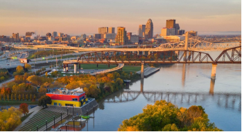
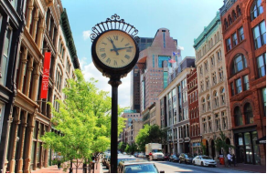
₋Louisville is the largest city in the Commonwealth of Kentucky and the 29th most-populous city in the United States. It is one of two cities in Kentucky designated as first-class, the other being Lexington, the state's second-largest city. Louisville is the historical seat and, since 2003, the nominal seat of Jefferson County, on the Indiana border.
₋Named after King Louis XVI of France, Louisville was founded in 1778 by George Rogers Clark, making it one of the oldest cities west of the Appalachians. With nearby Falls of the Ohio as the only major obstruction to river traffic between the upper Ohio River and the Gulf of Mexico, the settlement first grew as a portage site. It was the founding city of the Louisville and Nashville Railroad, which grew into a 6,000-mile (9,700 km) system across 13 states.
₋Today, the city is known as the home of legendary boxer Muhammad Ali, the Kentucky Derby, Kentucky Fried Chicken (KFC), the University of Louisville and its Cardinals, Louisville Slugger baseball bats, and three of Kentucky's six Fortune 500 companies: Humana, Kindred Healthcare, and Yum! Brands. Muhammad Ali International Airport, Louisville's main commercial airport, hosts UPS's worldwide hub.
₋Since 2003, Louisville's borders have been the same as those of Jefferson County, after a city-county merger. The official name of this consolidated city-county government is the Louisville/Jefferson County Metro Government, abbreviated to Louisville Metro. Despite the merger and renaming, the term "Jefferson County" continues to be used in some contexts in reference to Louisville Metro, particularly including the incorporated cities outside the "balance" which make up Louisville proper. The city's total consolidated population as of the 2019 census estimate was 766,757. However, the balance total of 617,638 excludes other incorporated places and semiautonomous towns within the county and is the population listed in most sources and national rankings.
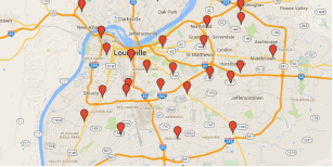
₋The Louisville-Jefferson County, KY-IN Metropolitan Statistical Area (MSA) includes Louisville-Jefferson County and 12 surrounding counties, seven in Kentucky and five in Southern Indiana. As of 2019, the MSA had a population of 1,265,108, ranking 46th nationally.
III.ECONOMY
₋The average salary in Louisville, KY is $61k. Trends in wages increased by 1.2 percent in Q1 2020. The cost of living in Louisville, KY is 8 percent higher than the national average. The most popular occupations in Louisville, KY are Project Manager, (Unspecified Type / General), Operations Manager, and Staff Accountant which pay between $37k and $106k per year. The most popular employers in Louisville, KY are Humana, Inc., University Of Louisville, and General Electric Co (GE).
₋Website: https://www.payscale.com/research/US/Location=Louisville-KY/Salary
IV.Industrial Characteristics
₋Louisville today is home to dozens of companies and organizations across several industrial classifications. However, the underpinning of the city's economy since its earliest days has been the shipping and cargo industries. Its strategic location at the Falls of the Ohio, as well as its unique position in the central United States (within one day's road travel to 60 percent of the cities in the continental U.S.) make it a practical location for the transfer of cargo along its route to other destinations. The Louisville and Portland Canal and the Louisville and Nashville Railroad were important links in water and rail transportation.
₋Louisville's importance to the shipping industry continues today with the presence of the Worldport global air-freight hub for UPS at Louisville International Airport. Louisville's location at the crossroads of three major interstate highways (I64, I65, and I71) also contributes to its modern-day strategic importance to the shipping and cargo industry. In addition, the Port of Louisville continues Louisville's river shipping presence at Jefferson Riverport International. As of 2003, Louisville ranks as the seventh-largest inland port in the United States.
₋Louisville is a significant center of manufacturing, with two major Ford Motor Company plants, and the headquarters and major home appliance factory of GE Appliances (a subsidiary of Haier). The city is also a major center of the American whiskey industry, with about one-third of all bourbon whiskey coming from Louisville. Brown-Forman, one of the major makers of American whiskey, is headquartered in Louisville and operates a distillery in the Louisville suburb of Shively. The current primary distillery site operated by Heaven Hill, called the Bernheim distillery, is also located in Louisville near Brown-Forman's distillery. Other distilleries and related businesses can also be found in neighboring cities in Kentucky, such as Bardstown, Clermont, Lawrenceburg, and Loretto. Similar to the Kentucky Bourbon Trail that links these central Kentucky locations, Louisville offers tourists its own "Urban Bourbon Trail", where people can stop at nearly 20 "area bars and restaurants, all offering at least 50 labels of America's only native spirit".
₋Not typically known for high tech outside of the previously identified industries, Code Louisville, the city's public–private partnership for teaching people entry level software development skills, received recognition in 2015 from then-President Barack Obama.
₋Louisville prides itself in its large assortment of small, independent businesses and restaurants, some of which have become known for their ingenuity and creativity. Several major motion pictures have also been filmed in or near Louisville, including The Insider, Goldfinger, Stripes, Lawn Dogs, Elizabethtown, and Secretariat.
V.Attractions
1.Speed Art Museum
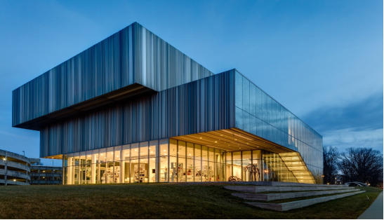
₋The Speed Art Museum, originally known as the J.B. Speed Memorial Museum, now colloquially referred to as the Speed by locals, is the oldest, largest, and foremost museum of art in Kentucky. It is located in Louisville, Kentucky on Third Street next to the University of Louisville Belknap campus and receives around 180,000 visits annually.
₋The museum offers visitors a variety of "art experiences" outside its collection and international exhibitions, including the Speed Concert Series, the Art Sparks Interactive Family Gallery, and the popular late-night event, After Hours at the Speed.
₋The Speed houses ancient, classical, and modern art from around the world. The focus of the collection is Western art, from antiquity to the present day. Holdings of paintings from the Netherlands, French and Italian works, and contemporary art are particularly strong, with sculpture prominent throughout.
₋The museum was built in 1927 by Arthur Loomis in the Neo-Classical style. Loomis was already well known in Louisville for landmarks like the Louisville Medical College and Levy Brothers. The original building was designed as an understated Beaux-Arts limestone facade. Hattie Bishop Speed established the museum in memorial of her husband James Breckenridge Speed, a prominent Louisville businessman, art collector, and philanthropist. Ms. Speed set up the endowment to fund the museum, encouraging the museum to never charge admission.
₋The museum underwent a $60 million expansion and renovation project from September 2012 to March 2016, designed by architect Kulapat Yantrasast of wHY architecture. During the closure, the museum opened Local Speed, a satellite space in Louisville's East Market District (NuLu) for rotating exhibitions, programs and events. Local Speed is located at 822 East Market Street.
₋The 62,500-square-foot North Building doubled the overall square footage and nearly tripled the gallery space from the previous wing. The expansion created a space for larger special exhibitions, new contemporary art galleries, a family education welcome center, 150-seat cinema, indoor/outdoor café, museum shop, and a multi-functional pavilion for performances, lectures and entertaining. Additionally, the new Elizabeth P. and Frederick K. Cressman Art Park and public Piazza was created for the display of sculpture.
₋Address: 2035 S 3rd St, Louisville, KY 40208, United States
₋Website: https://www.speedmuseum.org/
2.Louisville Waterfront Park
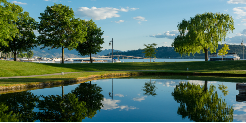
₋Louisville Waterfront Park is an 85-acre (340,000 m2) municipal park adjacent to the downtown area of Louisville, Kentucky and the Ohio River. Specifically, it is adjacent to Louisville's wharf and Riverfront Plaza/Belvedere, which are situated to the west of the park.
₋Phase I of Waterfront Park consists of approximately 55 acres (220,000 m2) and was dedicated on July 4, 1999. Louisville architects Bravura Corporation, together with Hargreaves Associates, were the designers of the park. Much of the park, such as the Great Lawn, had opened to the public by the fall of 1998. The initial development cost was about $58 million, a combination of public and private money. The site of the park was previously used for industrial purposes: scrap yards, sand pits and other industrial sites.
₋The park hosted hundreds of events in its first full season of use, including outdoor concerts and other festivals, with an estimated total attendance of more than a million people. There were problems early-on with the grass being too easily worn down by visitors.
₋Phase II of the park opened on June 10, 2004, and added approximately 17 acres (69,000 m²), including the Adventure Playground, which opened in July 2003. Included is an esplanade along the river's edge and a cafe plaza where the Tumbleweed cafe opened in the spring of 2005. The park also contains the Brown-Forman amphitheater, docks for transient boaters, and an area for a new rowing facility. The latter is used for the University of Louisville Women's Rowing Team, school and community rowing groups.
₋Construction on part of Phase III began in late spring of 2005, to add 13 acres (53,000 m²) and include the conversion of the former Big Four Railroad bridge going between the park and Jeffersonville, Indiana's waterfront park into a pedestrian bridge. Several more lawn areas, tree groves, walking paths, and picnic areas will also be added. As of May 2007 it was not clear when the long-planned conversion will begin, as funding had not yet been found.
₋In 2006, David Karem, executive director of the Waterfront Development Corporation, a public agency that operates Waterfront Park, wished to deter visitors from bathing in the large public fountain. He initiated a plan that was dependent on the average park visitor's "lack of understanding about water's chemical makeup", and arranged for signs that read: "DANGER! – WATER CONTAINS HIGH LEVELS OF HYDROGEN – KEEP OUT". The signs were posted on the fountain at public expense.[4][5] As it is true that ordinary water molecules each contain two atoms of hydrogen, and thus posed no danger, it is considered one of many water-related hoaxes.
₋In February 2011, Kentucky Governor Steve Beshear and Indiana Gov. Mitch Daniels announced that the two states, along with the City of Jeffersonville, will allocate $22 million in funding to complete the Big Four Bridge project, creating a pedestrian and bicycle path to link Louisville and Jeffersonville. Indiana will spend up to $8 million and the City of Jeffersonville will provide $2 million in matching dollars to pay for construction of a ramp to the Big Four Bridge. Kentucky is pledging $12 million to replace the deck on the bridge and connect it to the spiral ramp that has been completed in Waterfront Park. The Big Four Bridge is open to pedestrians and cyclists on the Louisville side. The Jeffersonville ramp for The Big Four Bridge, known to locals as the Walking Bridge, was scheduled for August 2013, but was pushed back to November 2013.
₋In July 2012, Jeffersonville City officials unveiled plans for a plaza, dubbed the "Big Four Station", costing approximately $3 million that will surround the new ramp, to be completed in early 2013, from the Big Four pedestrian bridge. The plaza was to include a covered playground, fountain, stage, pavilion and plenty of green space. The new plaza was expected to be finished by early 2014.
₋The bridge was completed in May 2014 with the opening of the Jeffersonville ramp.
₋In 2013 the park won the Rudy Bruner Award for Urban Excellence a national design award that seeks to identify and honor places that address economic and social concerns in urban design.
₋Address: 129 River Rd, Louisville, KY 40202, United States
₋Phone: +1 502-574-3768
₋Website: https://www.courier-journal.com/story/news/local/2019/07/10/what-20-years-of-waterfront-park-growth-changed-about-downtown-louisville-kentucky/1616244001/
3.Muhammad Ali Center
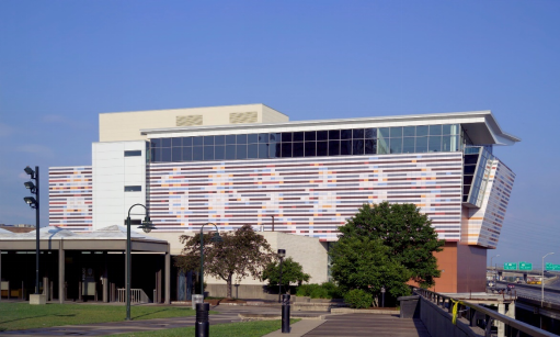
₋The Muhammad Ali Center is a non-profit museum and cultural center in Louisville, Kentucky. Dedicated to boxer Muhammad Ali, a native of Louisville, it is located in the city's West Main District.
₋The six-story, 96,750 sq ft (8,988 m2). museum opened on November 19, 2005 at a cost of $80 million. It also includes a 40,000 sq ft (3,700 m2) two-level amphitheater and a plaza.
₋On April 4, 2013, a new pedestrian bridge opened, helping residents and visitors connect from the Muhammad Ali Center's plaza to the Belvedere, the Waterfront, and other downtown attractions. The 170-foot-long walkway is nine feet wide, with exterior metal panels that complement the Ali Center plaza's design.
₋In 2020, the Muhammad Ali Center in Louisville and the SEEK Museum in Russellville were added to the U.S. Civil Rights Trail.
₋The cultural center features exhibitions regarding Ali's six core principles of confidence, conviction, dedication, giving, respect, and spirituality. Throughout his life, Muhammad Ali strived to be guided by these core principles in his quest to inspire people around the world, dedicating himself to helping others, being the best athlete he could be and by standing up for what he believed in.
₋An orientation theater helps present Ali's life. A mock boxing ring is recreated based on his Deer Lake Training Camp. A two-level pavilion, housed within a large elliptical room, features Ali's boxing memorabilia and history. A large projector displays the film The Greatest onto a full-sized boxing ring. There are also booths where visitors can view clips of Ali's greatest fights on video-on-demand terminals, which also feature pre- and post-fight interviews.
₋Another exhibit offers visitors the chance to explore sense of self, others and purpose through an interactive terminal program. Visitors are encouraged to share what they are fighting for in the Generation Ali Story Booths
₋Two art galleries, the LeRoy Neiman Gallery and the Howard L. Bingham Gallery, feature rotating exhibits that are located on the third floor.
₋Address: 144 N 6th St, Louisville, KY 40202, United States
₋Founded: November 19, 2005
₋Website: https://alicenter.org/
VI.History
₋Early history and founding
₋The rapids at the Falls of the Ohio created a barrier to river travel, and as a result, settlements grew up at this stopping point. The first European settlement in the vicinity of modern-day Louisville was on Corn Island in 1778 by Col. George Rogers Clark, credited as the founder of Louisville. Several landmarks in the community are named after him.
₋Two years later, in 1780, the Virginia General Assembly approved the town charter of Louisville. The city was named in honor of King Louis XVI of France, whose soldiers were then aiding Americans in the Revolutionary War. Early residents lived in forts to protect themselves from Indian raids, but moved out by the late 1780s. In 1803, explorers Meriwether Lewis and William Clark organized their expedition across America in the town of Clarksville, Indiana at the present-day Falls of the Ohio opposite Louisville, Kentucky.
₋19th century
₋The city's early growth was influenced by the fact that river boats had to be unloaded and moved downriver before reaching the falls. By 1828, the population had grown to 7,000 and Louisville became an incorporated city.
₋Early Louisville was a major shipping port and slaves worked in a variety of associated trades. The city was often a point of escape for slaves to the north, as Indiana was a free state.
₋During this point in the 1850s, the city was growing and vibrant, but that also came with negativity. It was the center of planning, supplies, recruiting, and transportation for numerous campaigns, especially in the Western Theater. Ethnic tensions rose, and on August 6, 1855, known as "Bloody Monday", Protestant mobs attacked German and Irish Catholic neighborhoods on election day, resulting in 22 deaths and widespread property damage. Then by 1861, the civil war broke out. During the Civil War, Louisville was a major stronghold of Union forces, which kept Kentucky firmly in the Union. By the end of the war, the city of Louisville itself had not been attacked, although skirmishes and battles, including the battles of Perryville and Corydon, took place nearby. After Reconstruction, returning Confederate veterans largely took political control of the city, leading to the jibe that Louisville joined the Confederacy after the war was over.
₋The first Kentucky Derby was held on May 17, 1875, at the Louisville Jockey Club track (later renamed Churchill Downs). The Derby was originally shepherded by Meriwether Lewis Clark, Jr., the grandson of William Clark of the Lewis and Clark Expedition, and grandnephew of the city's founder George Rogers Clark. Horse racing had a strong tradition in Kentucky, whose Inner Bluegrass Region had been a center of breeding high-quality livestock throughout the 19th century. Ten thousand spectators watched the first Derby, which Aristides won.
₋On March 27, 1890, the city was devastated and its downtown nearly destroyed when an F4 tornado tore through as part of the middle Mississippi Valley tornado outbreak. It is estimated that between 74 and 120 people were killed and 200 were injured. The damage cost the city $2.5 million (equivalent to $69 million in 2019).
₋20th and 21st centuries
₋In 1914, the City of Louisville passed a racially-based zoning residential zoning code, following Baltimore, Atlanta, and a handful of cities in the Carolinas. The NAACP challenged the ordinance in two cases. Two weeks after the ordinance enacted, an African-American named Arthur Harris moved into a house on a block designated for whites. He was prosecuted and found guilty. The second case was planned to create a test case. William Warley, the president of the local chapter of the NAACP, tendered a purchase offer on a white block from Charles Buchanan, a white real estate agent. Warley also wrote a letter declaring his intention to build a house on that lot and reside there. With the understanding that the Louisville ordinance made it illegal for him to live there, Warley withheld payment, setting in motion a breach of contract suit by Buchanan. By 1917 the US Supreme Court agreed to hear the case of Buchanan v. Warley. The court struck down the Louisville residential segregation ordinance, ruling that it violated the Fourteenth Amendment's due process clause.
₋In 1929, Louisville completed the lock and dam in the Falls of the Ohio and the city began referring to itself as "where Northern enterprise and Southern hospitality meet". Between the industrial boom of that year and through the Great Depression, Louisville gained 15,000 new residents, about three percent of them black, most fleeing poverty in rural areas.
₋Throughout January 1937, 19.17 inches (48.7 cm) of rain fell in Louisville, and by January 27, the Ohio River crested at a record 57.15 feet (17.42 m), almost 30 feet (9.1 m) above flood stage. These events triggered the "Great Flood of 1937", which lasted into early February. The flood submerged 60–70 percent of the city, caused complete loss of power for four days, and forced the evacuation of 175,000 or 230,000 residents, depending on sources. Ninety people died as a result of the flood. It led to dramatic changes in where residents lived. Today, the city is protected by numerous flood walls. After the flood, the areas of high elevation in the eastern part of the city had decades of residential growth.
₋Louisville was a center for factory war production during World War II. In May 1942, the U.S. government assigned the Curtiss-Wright Aircraft Company, a war plant located at Louisville's air field, for wartime aircraft production. The factory produced the C-46 Commando cargo plane, among other aircraft. In 1946, the factory was sold to International Harvester, which began large-scale production of tractors and agricultural equipment. In 1950, the Census Bureau reported Louisville's population as 84.3% white and 15.6% black.
₋Throughout the 1940s, there were more black police officers than any other southern city, though they were allowed to patrol only black districts. This lead, in part, made Louisville seem like a more racially progressive city than other southern cities, though only when black citizens accepted a lower status than white citizens. Many historians have referred to this "veil" of segregation as a "polite" racism. Historian George Wright stating that polite racism "often deluded both blacks and well-meaning whites into believing that real progress was being made in their city". For example, in the city Jim Crow practices were not maintained by law so much as by custom.
₋Similar to many other older American cities, Louisville began to experience a movement of people and businesses to the suburbs in the 1960s and 1970s. Middle class residents used newly built freeways and interstate highways to commute to work, moving into more distant but newer housing. Because of tax laws, businesses found it cheaper to build new rather than renovate older buildings. Economic changes included a decline in local manufacturing. The West End and older areas of the South End, in particular, began to decline economically as many local factories closed.
₋In 1974, a major (F4) tornado hit Louisville as part of the 1974 Super Outbreak of tornadoes that struck 13 states. It covered 21 miles (34 km) and destroyed several hundred homes in the Louisville area, causing two deaths.
₋Since the 1980s, many of the city's urban neighborhoods have been revitalized into areas popular with young professionals and college students. The greatest change has occurred along the Bardstown Road/Baxter Avenue and Frankfort Avenue corridors as well as the Old Louisville neighborhood. In recent years, such change has also occurred in the East Market District (NuLu).
₋Since the late 1990s, Downtown has experienced significant residential, tourist and retail growth, including the addition of major sports complexes KFC Yum! Center and Louisville Slugger Field, conversion of waterfront industrial sites into Waterfront Park, openings of varied museums (see Museums, galleries and interpretive centers below), and the refurbishing of the former Galleria into the bustling entertainment complex Fourth Street Live!, which opened in 2004.
VII.Other Information
₋Transportation
₋As with most American cities, transportation in Louisville is based primarily on automobiles. However, the city traces its foundation to the era where the river was the primary means of transportation, and railroads have been an important part of local industry for over a century. In more recent times, Louisville has become an international hub for air cargo.
₋Louisville has inner and outer interstate beltways, I264 and I265 respectively. Interstates I64 and I65 pass through Louisville, and I-71 has its southern terminus in Louisville. Since all three of these highways intersect at virtually the same location on the east side of downtown, this spot has become known as "Spaghetti Junction". Two bridges carry I64 and I65 over the Ohio River, and a third automobile bridge carries non-interstate traffic, including bicyclists and pedestrians. Immediately east of downtown is the Big Four Bridge, a former railroad bridge now renovated as a pedestrian bridge.
₋The Ohio River Bridges Project, a plan under consideration for decades to construct two new interstate bridges over the Ohio River to connect Louisville to Indiana, including a reconfiguration of Spaghetti Junction, began construction in 2012. One bridge, the Abraham Lincoln Bridge, is located downtown beside the existing Kennedy Bridge for relief of I65 traffic. The other, named the Lewis and Clark Bridge, connects I265 between the portions located in southeast Clark County, Indiana and northeast Jefferson County, Kentucky (Louisville Metro). Both bridges and corresponding construction were finished in 2016. As with any major project, there have been detractors and possible alternatives; one grassroots organization, 8664.org, has proposed options for downtown revitalization improvements, and a simpler and less expensive roadway design.
₋Louisville's main airport is the centrally located Louisville International Airport, whose IATA Airport code (SDF) reflects its former name of Standiford Field. The airport is also home to UPS's Worldport global air hub. UPS operates its largest package-handling hub at Louisville International Airport and bases its UPS Airlines division there. Over 4.2 million passengers and over 4.7 billion pounds (2,350,000 t) of cargo pass through the airport each year. It is also the third busiest airport in the United States in terms of cargo traffic, and seventh busiest for such in the world. Only about 35 minutes from Fort Knox, the airport is also a major hub for armed services personnel. The historic but smaller Bowman Field is used mainly for general aviation while nearby Clark Regional Airport is used mostly by private jets.
₋The McAlpine Locks and Dam is located on the Kentucky side of the Ohio River, near the downtown area. The locks were constructed to allow shipping past the Falls of the Ohio. In 2001 over 55 million tons of commodities passed through the locks.
₋Public transportation consists mainly of buses run by the Transit Authority of River City (TARC). The city buses serve all parts of downtown Louisville and Jefferson County, as well as Kentucky suburbs in Oldham County, Bullitt County, and the Indiana suburbs of Jeffersonville, Clarksville and New Albany. In addition to regular city buses, transit throughout the downtown hotel and shopping districts is served by a fleet of zero-emissions buses called LouLift. In late 2014, these vehicles replaced the series of motorized trolleys known as the Toonerville II Trolley. A light rail system has been studied and proposed for the city, but no plan was in development as of 2007.
₋Louisville has historically been a major center for railway traffic. The Louisville and Nashville Railroad was once headquartered here, before it was purchased by CSX Transportation. Today the city is served by two major freight railroads, CSX (with a major classification yard in the southern part of the metro area) and Norfolk Southern. Five major main lines connect Louisville to the rest of the region. Two regional railroads, the Paducah and Louisville Railway and the Louisville and Indiana Railroad, also serve the city. With the discontinuance of the stop in Louisville in 2003 for a more northerly route between New York and Chicago, the Kentucky Cardinal no longer serves the city; it is thus the fifth largest city in the country with no passenger rail service.
₋In 2016 Walk Score ranked Louisville 43rd "most walkable" of 141 U.S. cities with a population greater than 200,000.
₋Utilities
₋Completed in 1860, the Louisville Water Tower is the oldest water tower in the U.S.
₋Electricity is provided to the Louisville Metro area by Louisville Gas & Electric. Water is provided by the Louisville Water Company, which provides water to more than 800,000 residents in Louisville as well as parts of Oldham and Bullitt counties. Additionally, they provide wholesale water to the outlying counties of Shelby, Spencer and Nelson.
₋The Ohio River provides for most of the city's source of drinking water. Water is drawn from the river at two points: the raw water pump station at Zorn Avenue and River Road, and the B.E. Payne Pump Station northeast of Harrods Creek. Water is also obtained from a riverbank infiltration well at the Payne Plant. There are also two water treatment plants serving the Louisville Metro area: The Crescent Hill Treatment Plant and the B.E. Payne Treatment Plant. In June 2008, the Louisville Water Company received the "Best of the Best" award from the American Water Works Association, citing it as the best-tasting drinking water in the country.
VIII.Contact Information
Government
Type: Mayor–council
Mayor: Greg Fischer (D)
Metro Council: 26 council members
City Hall
TEL: (502) 574-2003
Opening Hours: 8 a.m. - 5 p.m.
Address;
527 W. Jefferson Street
Louisville, KY 40202
Website: https://louisvilleky.gov/contact
