Topeka, Kansas 作者: 来源: 发布时间:2021-11-04
I.Population and Area
₋Area
Land: 60.17 sq mi (155.84 km2)
₋Population
Total: 125,310
Density: 2,100/sq mi (800/km2)
II.Natural Geography
City Overview
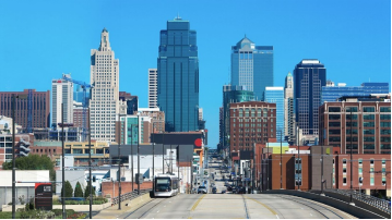
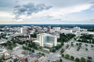
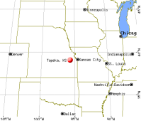
₋Topeka is the capital city of the U.S. state of Kansas and the seat of Shawnee County. It is along the Kansas River in the central part of Shawnee County, in northeast Kansas, in the Central United States. As of the 2010 census, the city population was 127,473. The Topeka Metropolitan Statistical Area, which includes Shawnee, Jackson, Jefferson, Osage, and Wabaunsee counties, had a population of 233,870 in the 2010 census.
₋The name Topeka is a Kansa-Osage sentence that means "place where we dug potatoes", or "a good place to dig potatoes". As a placename, Topeka was first recorded in 1826 as the Kansa name for what is now called the Kansas River. Topeka's founders chose the name in 1855 because it "was novel, of Indian origin and euphonious of sound." The mixed-blood Kansa Native American, Joseph James, called Jojim, is credited with suggesting Topeka's name. The city, laid out in 1854, was one of the Free-State towns founded by Eastern antislavery men immediately after the passage of the Kansas–Nebraska Bill. In 1857, Topeka was chartered as a city.
₋The city is well known for the landmark U.S. Supreme Court case Brown v. Board of Education of Topeka, which overturned Plessy vs. Ferguso n and declared racial segregation in public schools to be unconstitutional. The U.S. Navy has named three ships USS Topeka after the city.
III.ECONOMY
₋The average salary in Topeka, KS is $16.78. Trends in wages decreased by -100.0 percent in Q1 2020. The cost of living in Topeka, KS is 4 percent higher than the national average. The most popular occupations in Topeka, KS are Certified Nurse Assistant (CNA), Licensed Practical Nurse (LPN), and Registered Nurse (RN) which pay between $10.59 and $28.65 per year. The most popular employers in Topeka, KS are Stormont -Vail Healthcare, State of Kansas (KS), and Reser's Fine Foods, Inc..
₋Website: https://www.payscale.com/research/US/Location=Topeka-KS/Salary
IV.Industrial Characteristics
₋Being the state's capital city, Topeka's largest employer is the State of Kansas—employing about 8,400 people, or 69% of the city's government workers. Altogether, government workers make up one out of every five employed persons in the city.
₋The educational, health and social services industry makes up the largest proportion of the working population (22.4%). The four school districts employ nearly 4,700 people, and Washburn University employs about 1,650. Three of the largest employers are Stormont-Vail HealthCare (with about 3,100 employees), St. Francis Health Center (1,800), and Colmery-O'Neil VA Hospital (900).
₋The retail trade employs more than a tenth of the working population (11.5%) with Wal-Mart and Dillons having the greater share. Nearly another tenth is employed in manufacturing (9.0%). Top manufacturers include Goodyear Tire and Rubber Company, Hill's Pet Nutrition, Frito-Lay, and Jostens Printing and Publishing. Jostens announced plans in May 2012 to move production from its Topeka facility to Clarksville, Tennessee, affecting approximately 372 employee positions. Southwest Publishing & Mailing Corporation, a smaller employer, has its headquarters in Topeka.
₋Other industries are finance, insurance, real estate, and rental and leasing (7.8%); professional, scientific, management, administrative, and waste management services (7.6%); arts, entertainment, recreation, accommodation and food services (7.2%); construction (6.0%); transportation and warehousing, and utilities (5.8%); and wholesale trade (3.2%). Blue Cross and Blue Shield of Kansas is the largest insurance employer, with about 1,800 employees. BNSF Railway is the largest transportation employer, with about 1,100. Evergy employs nearly 800. About a tenth of the working population is employed in public administration (9.9%).
V.Attractions
1. Kansas State Capitol
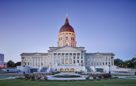
₋The Kansas State Capitol, known also as the Kansas Statehouse, is the building housing the executive and legislative branches of government for the U.S. state of Kansas. Located in the city of Topeka, which has served as the capital of Kansas since the territory became a state in 1861, the building is the second to serve as the Kansas Capitol.
₋The dome, at 304 ft (93 m), is taller than the 288 ft (88 m) United States Capitol dome, although its diameter (50 ft (15 m)) is approximately half that of the national capitol (96 ft (29 m)). It is one of the few capitols in the United States that continue to offer tours that go to the top of the dome. Visitors enter the dome by climbing 296 steps leading from the fifth floor to the top.
₋19th century
₋The land for Capitol Square was donated by Cyrus K. Holliday via his Topeka Town Company in 1862. The master architect was Edward Townsend Mix with the wings designed by John G. Haskell. Construction on the East Wing began in 1866, using "native" limestone from Geary County, Kansas. Construction began on the West Wing in 1879 using limestone from Cottonwood Falls, Kansas and in 1881, the legislature authorized and appropriated funds for the construction of a central building to link the two wings. Construction of this central building began in 1886, and the contract for dome construction was let in May, 1889.
₋20th century
₋The building was declared officially complete in 1903, after 37 years of construction.
₋It was not until 1988 that a design for a sculpture to stand atop the dome was finally approved. Ad Astra, a 22 2⁄12-foot (6.756 m) bronze sculpture weighing 4,420 pounds (2,000 kg), was installed atop the dome on October 10, 2002. The sculpture, by Richard Bergen, depicts a Kansa Native American with bow and arrow pointed at the North Star and was chosen from 27 entries to adorn the dome. The title Ad Astra is Latin shortening of the state motto Ad Astra Per Aspera To the stars through difficulty.
₋21st century
₋The building was featured prominently on Kansas license plates issued from January 2001 until April 2007.
₋In December 2001, the Statehouse began a $120 million modernization project, led by Treanor Architects; the project included restoration of its first through fifth floors, the rehabilitation and expansion of its basement, restoration of its exterior masonry and copper roof/dome. By the time the project finished in spring 2014, scope creep and delays resulted in a total cost of $332 million, covering "new heating and cooling systems, greater security and restroom accessibility, a new parking garage, visitor center, underground office space and replacing the roof and dome."
₋Address: SW 8th & SW Van Buren, Topeka, KS 66612, United States
₋Opened: March 24, 1903
₋Phone: +1 785-296-3966
₋Architects: John G. Haskell, E. Townsend Mix
₋Website: https://www.kshs.org/p/facility-use-kansas-state-capitol/19178
2.Kansas Museum of History
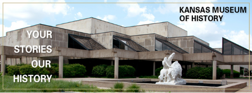
₋The Kansas Museum of History is the state historical museum in Topeka, Kansas, United States. It presents Kansas history from the prehistoric to modern eras in 30,000 square feet (2,800 m2) of exhibits. The galleries feature a train (Atchison, Topeka and Santa Fe locomotive with two cars), full-sized tipi in the Southern Cheyenne style, a 1950s diner, and many other large features. Major topics covered in the main gallery include Native American tribal history, westward movement on the Oregon and Santa Fe trails, early settlers, the Bleeding Kansas and Civil War eras, and Populism at the turn of the 20th century.
₋The museum is a division of the Kansas Historical Society, which was founded in 1875 by Kansas newspaper editors and publishers. Its first home was in the Kansas State Capitol.
₋The current museum building was built in 1980s to house the Society's object collections and exhibits. Dubbed the Kansas Museum of History, it opened in 1984 at an 80-acre (320,000 m2) site in west Topeka near the historic Potawatomi Mission. In addition to galleries, the building also houses a museum store, classrooms, and labs for conservation and exhibit fabrication.
₋In the mid-1990s, the rest of the Society's divisions moved to the new Center for Historical Research adjacent to the museum. Today the complex includes nature trails, an education and conference center, and a historic one-room school used for educational programs.
₋The museum's most popular programs include its changing exhibits schedule, the Cool Things section of the website (featuring interesting objects from the collections), and the related Cool Things podcasts.
₋Address: 6425 SW 6th Ave, Topeka, KS 66615, United States
₋Opened: 1984
₋Phone: +1 785-272-8681
₋Website: https://www.kshs.org/p/kansas-museum-of-history/19578
3.Combat Air Museum
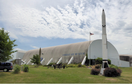
₋The Combat Air Museum is a non profit aviation museum at Topeka Regional Airport in Williamsport Township, Shawnee County, near Topeka, Kansas. The museum is dedicated to the creation of facilities and resources for the education of the local and regional communities through the collection, preservation, conservation and exhibition of aircraft, information, artifacts, technology and art associated with the military aviation history of the United States.
₋Topeka Regional Airport is a joint civil-military public airport located six miles (10 km) south of the central business district of Topeka.
₋Topeka Regional Airport is owned by the Metropolitan Topeka Airport Authority (MTAA). The Museum rents two hangars from the MTAA. It is one of a handful of major aviation museums in the United States located on an active air field.
₋Topeka Regional Airport, formerly Forbes Air Force Base, is home to Forbes Air National Guard Base and the 190th Air Refueling Wing (190 ARW) of the Kansas Air National Guard, the 1st Battalion, 108th Aviation Regiment of the Kansas Army National Guard, and other private commercial operators.
₋Visitors to the Museum are regularly treated to flying activities of Air Force tanker and fighter aircraft and Army helicopter operations. With the second longest runway in the State of Kansas, large refueling tanker aircraft of the Air National Guard and army troop transports often fill the skies around the Museum.
₋Address: Topeka Regional Airport, 7016 SE Forbes Ave, Topeka, KS 66619, United States
₋Phone: +1 785-862-3303
₋Website:http://www.combatairmuseum.org/
VI.History
₋Early history
₋For many millennia, Native Americans inhabited the Great Plains of North America. From the 16th to the mid-18th centuries, the Kingdom of France claimed ownership of large parts of North America. In 1762, late in the French and Indian War, France secretly ceded Louisiana west of the Mississippi River to Spain in the Treaty of Fontainebleau. In 1800, Spain returned Louisiana to France. In 1803, the United States purchased the territory, which included most of the land of modern Kansas, from France for $15 million.
₋19th century
₋In the 1840s, wagon trains made their way west from Independence, Missouri, on a journey of 2,000 miles (3,000 km), following what would later be known as the Oregon Trail. About 60 miles (97 km) west of Kansas City, Missouri, three half Kansas Indian sisters married to the French-Canadian Pappan brothers established a ferry service allowing travelers to cross the Kansas River at what is now Topeka. During the 1840s and into the 1850s, travelers could reliably find a way across the river, but little else was in the area.
₋In the early 1850s, traffic along the Oregon Trail was supplemented by trade on a new military road stretching from Fort Leavenworth through Topeka to the newly established Fort Riley. In 1854, after completion of the first cabin, nine men established the Topeka Town Association. The group included Cyrus K. Holliday, an "idea man" who would become mayor of Topeka and founder of the Atchison, Topeka & Santa Fe Railroad. Soon, steamboats were regularly docking at the Topeka landing, depositing meat, lumber, and flour and returning eastward with potatoes, corn, and wheat. By the late 1860s, Topeka had become a commercial hub that offered many Victorian era comforts.
₋Topeka was a bastion for the free-state movement during the problems in Kansas Territory between abolitionist and pro-slavery settlers (the latter of whom controlled the legal government based out of Lecompton). After southern forces barricaded Topeka in 1856, Topeka's leaders took actions to defend the free-state town from invasion. A militia was organized and stone fortifications were built on Quincy Street. The fortifications seemed to consist of low-lying earthwork levies strengthened by the presence of at least one cannon. The militia manned the fortifications until at least September 1856, when the siege around the town was lifted.
₋After a decade of abolitionist and pro-slavery conflict that gave the territory the nickname Bleeding Kansas, Kansas was admitted to the Union in 1861 as the 34th state. Topeka was chosen as the capital, with Dr. Charles Robinson as the first governor. In 1862, Cyrus K. Holliday donated a tract of land to the state for the construction of a state capitol. Construction of the Kansas State Capitol began in 1866. It would take 37 years to build the capitol, first the east wing, and then the west wing, and finally the central building, using Kansas limestone. In fall 1864 a stockade fort, later named Fort Simple, was built in the intersection of 6th and Kansas Avenues to protect Topeka, should Confederate forces then in Missouri decide to attack the city. It was abandoned by April 1865 and demolished in April 1867.
₋State officers first used the state capitol in 1869, moving from Constitution Hall, what is now 427-429 S. Kansas Avenue. Besides being used as the Kansas statehouse from 1863 to 1869, Constitution Hall is the site where anti-slavery settlers convened in 1855 to write the first of four state constitutions, making it the "Free State Capitol." The National Park Service recognizes Constitution Hall - Topeka as headquarters in the operation of the Lane Trail to Freedom on the Underground Railroad, the chief slave escape passage and free trade road.
₋Although the drought of 1860 and the ensuing period of the Civil War slowed the growth of Topeka and the state, Topeka kept pace with the revival and period of growth Kansas enjoyed from the close of the war in 1865 until 1870. In the 1870s, many former slaves known as Exodusters, settled on the east side of Lincoln Street between Munson and Twelfth Streets. The area was known as Tennessee Town because so many of them were from the Volunteer state. Dr. Charles Sheldon, pastor of the Central Congregational Church, organized the first African American Kindergarten west of the Mississippi in 1893.
₋Lincoln College, now Washburn University, was established in 1865 in Topeka by a charter issued by the State of Kansas and the General Association of Congregational Ministers and Churches of Kansas. In 1869, the railway started moving westward from Topeka, where general offices and machine shops of the Atchison, Topeka & Santa Fe Railroad system were established in 1878.
₋During the late 1880s, Topeka passed through a boom period that ended in disaster. There was vast speculation on town lots. The 1889 bubble burst and many investors were ruined. Topeka, however, doubled in population during the period and was able to weather the depressions of the 1890s.
₋Early in the 20th century, another kind of boom, this time the automobile industry, took off, and numerous pioneering companies appeared and disappeared. Topeka was not left out. The Smith Automobile Company was founded there in 1902, lasting until 1912.
₋20th century
₋Home to the first African-American kindergarten west of the Mississippi River, Topeka became the home of Oliver Brown, the named plaintiff in Brown v. Board of Education which was the case responsible for eliminating the standard of "separate but equal", and requiring racial integration in American public schools. In 1960, the Census Bureau reported Topeka's population as 91.8% white and 7.7% black.
₋At the time the suit was filed, only the elementary schools were segregated in Topeka, and Topeka High School had been fully integrated since its inception in 1871. Furthermore, Topeka High School was the only public high school in the city of Topeka. Other rural high schools existed, such as Washburn Rural High School—created in 1918—and Seaman High School—created in 1920. Highland Park High School became part of the Topeka school system in 1959 along with the opening of Topeka West High School in 1961. A Catholic high school —Assumption High School, later renamed Capitol Catholic High School, then in 1939 again renamed, to Hayden High School after its founder, Father Francis Hayden — also served the city beginning in 1911.
₋Monroe Elementary, a segregated school that figured in the historic Brown v. Board of Education decision, through the efforts of The Brown Foundation working with the Kansas Congressional delegation place in the early 1990s, is now Brown v. Board of Education National Historic Site. The Brown Foundation is largely responsible for the content of the interpretive exhibits at the Historic Site. The National Historic Site was opened by President George W. Bush on May 17, 2004.
₋Topeka has struggled with the burden of racial discrimination even after Brown. New lawsuits attempted unsuccessfully to force suburban school districts that ring the city to participate in racial integration with the inner city district. In the late 1980s a group of citizens calling themselves the Task Force to Overcome Racism in Topeka formed to address the problem in a more organized way.
₋On June 8, 1966, Topeka was struck by a tornado rated F5 on the Fujita scale. It started on the southwest side of town, moving northeast, passing over a local landmark named Burnett's Mound. According to a local Indian legend, this mound was thought to protect the city from tornadoes if left undisturbed. A few years prior to the tornado strike saw development near the mound including a water tank constructed near the top of the mound against the warnings of local Native Americans. The tornado went on to rip through the city, hitting the downtown area and Washburn University. Total dollar cost was put at $100 million making it, at the time, one of the most costly tornadoes in American history. Even to this day, with inflation factored in, the Topeka tornado stands as one of the most costly on record. It also helped bring to prominence future CBS and A&E broadcaster Bill Kurtis, who became well known for his televised admonition to "...take cover, for God's sake, take cover!" on WIBW-TV during the tornado. (The city is home of a National Weather Service Forecast Office that serves 23 counties in north-central, northeast, and east-central Kansas).
₋Topeka recovered from the 1966 tornado and has sustained steady economic growth. Washburn University, which lost several historic buildings, received financial support from the community and alumni to rebuild many school facilities. Today, university facilities offer more than one million square feet of modern academic and support space.
₋In 1974, Forbes Air Force Base closed and more than 10,000 people left Topeka, influencing the city's growth patterns for years to come. During the 1980s, Topeka citizens voted to build a new airport and convention center and to change the form of city government. West Ridge Mall opened in 1988, replacing the White Lakes Mall which opened in 1964.
₋In 1989, Topeka became a motorsports mecca with the opening of Heartland Park Topeka. The Topeka Performing Arts Center opened in 1991. In the early 1990s, the city experienced business growth with Reser's Fine Foods locating in Topeka and expansions for Santa Fe and Hill's Pet Nutrition.
₋During the 1990s voters approved bond issues for public school improvements including magnet schools, technology, air conditioning, classrooms, and a sports complex. Voters also approved a quarter-cent sales tax for a new Law Enforcement Center, and in 1996 approved an extension of the sales tax for the East Topeka Interchange connecting the Oakland Expressway, K-4, I-70, and the Kansas Turnpike. During the 1990s Shawnee county voters approved tax measures to expand the Topeka and Shawnee County Public Library. The Kansas Legislature and Governor also approved legislation to replace the majority of the property tax supporting Washburn University with a countywide sales tax.
₋21st century
₋In 2000 the citizens again voted to extend the quarter-cent sales tax, this time for the economic development of Topeka and Shawnee County. In August, 2004, Shawnee County citizens voted to repeal the 2000 quarter-cent sales tax and replace it with a 12- year half-cent sales tax designated for economic development, roads, and bridges. Each year the sales tax funds provide $5 million designated for business development job creation incentives, and $9 million for roads and bridges. Planning is under way to continue to redevelop areas along the Kansas River, which runs west to east through Topeka. In the Kansas River Corridor through the center of town, Downtown Topeka has experienced apartment and condominium loft development, and façade and streetscape improvements.
₋Google, Kansas
₋On March 1, 2010, Topeka Mayor Bill Bunten issued a proclamation calling for Topeka to be known for the month of March as "Google, Kansas, the capital city of fiber optics." The name change came from Ryan Gigous, who wanted to "re-brand" the city with a simple gesture. This was to help "support continuing efforts to bring Google's fiber experiment" to Topeka, though it was not a legal name change. Lawyers advised the city council and mayor against an official name change. Google jokingly announced it would change its name to Topeka to "honor that moving gesture" on April 1, 2010 (April Fools' Day) and changed its home page to say Topeka. In its official blog, Google announced this change thus affected all of its services as well as its culture, e.g. "Googlers" to "Topekans", "Project Virgle" to "Project Vireka", and proper usage of "Topeka" as an adjective and not a verb, to avoid the trademark becoming genericized.
VII.Other Information
₋Transportation
₋I-70, I-470, and I-335 all go through the City of Topeka. I-335 is part of the Kansas Turnpike where it passes through Topeka. Other major highways include: US-24, US-40, US-75, and K-4. Major roads within the city include NW/SW Topeka Blvd. SW Wanamaker Road. N/S Kansas Ave. SW/SE 29th St. SE/SW 21st St. SE California Ave. SW Gage Blvd. and SW Fairlawn Rd.
₋Topeka Regional Airport (FOE) formerly known as Forbes Field is in south Topeka in Pauline, Kansas. Forbes Field also serves as an Air National Guard base, home of the highly decorated 190th Air Refueling Wing. Manhattan Regional Airport (MHK) in Manhattan, Kansas is the next closest commercial airport; Kansas City International Airport (MCI) in Kansas City is the closest major airport. Philip Billard Municipal Airport (TOP) is Topeka's Oakland area.
₋Passenger rail service provided by Amtrak stops at the Topeka Station. Service is via the Chicago-to-Los Angeles Southwest Chief during the early morning hours and makes intermediate stops at Lawrence and Kansas City. The Kansas Department of Transportation has asked Amtrak to study additional service, including daytime service to Oklahoma City. The Burlington Northern Santa Fe railroad and Union Pacific Railroad provide freight service as well as several short line railroads throughout the state.
₋Greyhound Lines provides bus service westward towards Denver, Colorado, eastward to Kansas City, Missouri, southwest to Wichita, Kansas.
₋The Topeka Metropolitan Transit Authority provides local transit service. The agency offers bus service from 6 am to 6:30 pm Monday through Friday, and 7 am to 5 pm on Saturday. It also provides demand response general public taxi service which operates evenings from 8 pm until 11:30 pm and on Sundays.
VIII.Contact Information
Government
Type: Council-Manager
Mayor: Michelle De La Isla (D)
City Manager: Brent Trout
City Hall
TEL: 785-368-3111
Address:
215 SE 7th St
Topeka, KS 66603
Website: https://www.topeka.org/contact-us/
