Hilo, Hawaii 作者: 来源: 发布时间:2021-07-20
I.Population and Area
₋Area
Land: 58.3 sq mi (151.0 km2)
₋Population
Total: 43,263
Density: 810/sq mi (312.9/km2)
II.Natural Geography
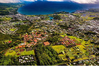
₋Hilo is the largest town and census-designated place (CDP) in Hawaii County, Hawaii, United States, which encompasses the Island of Hawaiʻi. The population was 43,263 according to the 2010 census.
₋Hilo is the county seat of the County of Hawaiʻi and is in the District of South Hilo. The town overlooks Hilo Bay, at the base of two shield volcanoes, Mauna Loa, an active volcano, and Mauna Kea, a dormant volcano. Mauna Kea is the site of some of the world's most important ground-based astronomical observatories. M uch of the city is at risk from lava flows from Mauna Loa, and the bayfront was twice destroyed by tsunamis. The majority of human settlement in Hilo stretches from Hilo Bay to Waiākea-Uka, on the flanks of the volcanoes.
₋Hilo is home to the University of Hawaiʻi at Hilo, ʻImiloa Astronomy Center, as well as the Merrie Monarch Festival, a week-long celebration of ancient and modern hula that takes place annually after Easter. Hilo is also home to the Mauna Loa Macadamia Nut Corporation, one of the world's leading producers of macadamia nuts. The town is served by Hilo International Airport.
III.GDP
₋The average salary in Hilo, HI is $17.59. Trends in wages decreased by -100.0 percent in Q1 2020. The cost of living in Hilo, HI is 46 percent higher than the national average. The most popular occupations in Hilo, HI are Registered Nurse (RN), Certified Nurse Assistant (CNA), and Licensed Practical Nurse (LPN) which pay between $11.05 and $34.37 per year. The most popular employers in Hilo, HI are Life Care Centers of America, The Home Depot Inc., and Bay Clinic.
₋Website: https://www.payscale.com/research/US/Location=Hilo-HI/Salary
IV.Industrial Characteristics
₋The oldest city in the Hawaiian archipelago, Hilo's economy was historically based on the sugar plantations of its surrounding areas, prior to their closure in the 1990s.
₋Hilo has a fairly significant tourism sector, but gets less than half the annual visitors as the western Kona Coast of the Big Island, which has fancy resorts and sunny beaches.
₋A main source of tourism in Hilo is the annual week-long Merrie Monarch Festival, the world's preeminent hula competition and festival, which brings in visitors and participants from all over the world. It is held in the spring of each year beginning on Easter Sunday.
₋The local orchid society hosts the largest and most comprehensive orchid show in the state, the annual Hilo Orchid Show, which has been presented since 1951 and draws visitors and entrants worldwide.
₋Hilo is home to Hawaii's only tsunami museum, mostly dedicated to the 1946 Pacific tsunami, and is notable for the banyan trees planted by Babe Ruth, Amelia Earhart and other celebrities. It is home to the Pana'ewa Rainforest Zoo, shopping centers, cafés and other eateries, movie theaters, hotels, restaurants, and a developed downtown area with a Farmers Market.
₋The Mauna Loa Macadamia Nut Corporation is in Hilo, south of the main town off Hawaii Route 11, north of Keaʻau.
₋Hilo is known for the Mokupāpapa Discovery Center in the Koehnen Building downtown. The museum features interactive and educational exhibits and is dedicated to creating public awareness of the Papahānaumokuākea Marine National Monument and marine conservation issues.
₋Hilo is home to most of the astronomical observatories on Mauna Kea as well as the ʻImiloa Planetarium and Museum. Astronomy has an economic impact of $100 million annually on the island. Astronomy on Mauna Kea was developed at the invitation of the Hawaii Chamber of Commerce following the collapse of the sugar cane industry.
V.Attractions
1. Hawaii Tropical Botanical Garden
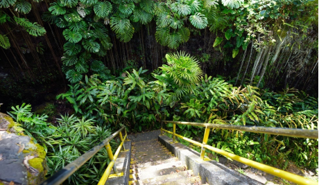
₋The Hawaii Tropical Botanical Garden (17 acres) is a nonprofit botanical garden and nature preserve located on the 4 mile scenic route off of Route 19 at 27-717 Old Māmalahoa Highway, Pāpa'ikou, Hawaii (island), Hawaii. It is open daily except Thanksgiving, Christmas, and New Year's Day. An admission fee is charged to the general public; those with a military I.D. are admitted free of charge.
₋ The garden is located in a scenic valley opening out to Onomea Bay, and features streams, waterfalls and a boardwalk along the ocean. It was created by Dan J. Lutkenhouse, who purchased the property in 1977 and began to develop it as a botanical garden. It opened to the public in 1984, and was donated by the Lutkenhouses to a nonprofit trust in 1995.
₋Today the garden contains over 2,000 plant species, representing more than 125 families and 750 genera, with good collections of palms (nearly 200 species), heliconias (more than 80 species), and bromeliads (more than 80 species). Some of the garden's mango and coconut palm trees are over 100 years old.
₋The garden combines water and flora: A three-tiered waterfall (Onomea Falls) provides one of several water views which include Boulder Creek and the lava tubes on Onomea Bay.
₋Address: 27-717 Mamalahoa Hwy, Papaikou, HI 96781, United States
₋Phone: +1 808-964-5233
₋Website: https://www.hawaii.com/big-island/attractions/hawaii-tropical-botanical-gardens/
2. Rainbow Falls
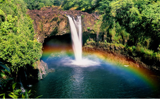
₋Rainbow (Waiānuenue) Falls is a waterfall located in Hilo, Hawaii. It is 80 ft (24 m) tall and almost 100 ft (30 m) in diameter. The falls are part of the Hawai'i State Parks. There is no fee to see the falls.
₋At Rainbow (Waiānuenue) Falls, the Wailuku River rushes into a large pool below. The gorge is blanketed by lush, dense nonnative tropical rainforest and the turquoise colored pool is bordered by beautiful, although nonnative, wild ginger. Monstera is also in abundance. The falls are accessible via Wailuku River State Park, Waiānuenue Avenue, coordinates 19°43′9″N 155°6′34″W, and are best seen from the park's viewing platform.
₋Known in the Hawaiian language as Waiānuenue (literally "rainbow water"), the falls flows over a natural lava cave, the mythological home to Hina, an ancient Hawaiian goddess.
₋Rainbow Falls derives its name from the fact that, on sunny mornings around 10AM, rainbows can be seen in the mist thrown up by the waterfall.
₋Website: https://www.hawaii.com/big-island/attractions/rainbow-falls/
3. Liliʻuokalani Park and Gardens
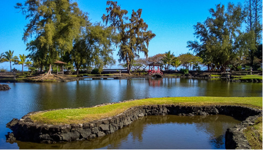
₋Liliʻuokalani Park and Gardens is a 24.14-acre (97,700 m2) park with Japanese gardens, located on Banyan Drive in Hilo on the island of Hawaiʻi.
₋The park's site was donated by Queen Liliʻuokalani, and lies southeast of downtown Hilo, on the Waiakea Peninsula in Hilo Bay. Much of the park now consists of Edo-style Japanese gardens, built 1917-1919, and said to be the largest such gardens outside Japan. The gardens contain Waihonu Pond as well as bridges, ponds, pagodas, statues, torii, and a Japanese teahouse.
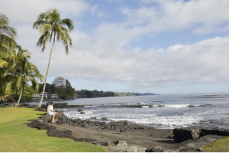
₋Included in the park is the small island called Moku ola, (also known as Coconut Island), connected to the park by a footbridge. It is a good place for a picnic, and some limited swimming. The name Moku ola literally means "island of life" in the Hawaiian language, since it was the site of an ancient temple dedicated to healing. There is a stone tower on the east side of the island which is the remnant of the old footbridge which was destroyed by a tsunami. From Coconut Island one has a great view of Hilo Bayfront, Downtown Hilo, and the rest of Hilo Bay. To the east, you can see the massive breakwater protecting Hilo Bay. It is located at coordinates 19°43′36″N 155°4′6″W It is maintained by the County of Hawaii and non-profit Friends of Liliuokalani Gardens.
₋The park is a popular location for public events, exercise, and dog-walking.
₋Address: 189 Lihiwai St #151, Hilo, HI 96720, United States
₋Website: https://www.gohawaii.com/islands/hawaii-big-island/regions/hilo/liliuokalani-gardens
VI.History
₋Around 1100 AD, the first Hilo inhabitants arrived, bringing with them Polynesian knowledge and traditions. Although archaeological evidence is scant, oral history has many references to people living in Hilo, along the Wailuku and Wailoa rivers during the time of ancient Hawaii. Oral history gives the meaning of Hilo as "to twist".
₋Originally, the name "Hilo" applied to a district encompassing much of the east coast of the island of Hawaiʻi, now divided into the District of South Hilo and the District of North Hilo. When William Ellis visited in 1823, the main settlement there was Waiākea on the south shore of Hilo Bay. Missionaries came to the district in the early-to-middle 19th century, founding Haili Church.
₋Hilo expanded as sugar plantations in the surrounding area created jobs and drew in many workers from Asia. For example, by 1887, 26,000 Chinese workers worked in Hawai'i's sugar cane plantations, one of which was the Hilo Sugar Mill. At that time, the Hilo Sugar Mill produced 3,500 tons of sugar annually.
₋A breakwater across Hilo Bay was begun in the first decade of the 20th century and completed in 1929. On April 1, 1946, a 7.8-magnitude earthquake near the Aleutian Islands created a 46-foot-high (14 m) tsunami that hit Hilo 4.9 hours later, killing 160 people. In response, an early warning system, the Pacific Tsunami Warning Center, was established in 1949 to track these killer waves and provide warning. This tsunami also caused the end of the Hawaii Consolidated Railway, and instead the Hawaii Belt Road was built north of Hilo using some of the old railbed.
₋On May 22, 1960, another tsunami, caused by a 9.5-magnitude earthquake off the coast of Chile that day, claimed 61 lives, allegedly due to the failure of people to heed warning sirens. Low-lying bayfront areas of the city on Waiākea peninsula and along Hilo Bay, previously populated, were rededicated as parks and memorials.
₋Hilo expanded inland beginning in the 1960s. The downtown found a new role in the 1980s as the city's cultural center with several galleries and museums opening; the Palace Theater reopened in 1998 as an arthouse cinema.
₋Closure of the sugar plantations (including those in Hāmākua) during the 1990s hurt the local economy, coinciding with a general statewide slump. Hilo in recent years has seen commercial and population growth.
VII.Other Information
₋Education
₋Main article: Schools of Hilo, Hawaii
₋Hilo is home to a number of educational institutions, including two post-secondary institutions, the University of Hawaiʻi at Hilo and Hawaiʻi Community College, and the Hilo and Waiakea primary and secondary school districts. Charter schools in the area serve primary and secondary students.
₋Government
₋Although sometimes called a city, Hilo is not an incorporated city, and does not have a municipal government. The entire island, which is between the slightly larger state of Connecticut and smaller Rhode Island in size, is under the jurisdiction of the County of Hawaiʻi, of which Hilo is the county seat.
₋Hilo is home to county, state, and federal offices.
VIII.Contact Information
₋Government
Mayor: Harry Kim
₋City Hall
₋Email: hcoa@hawaiiantel.net
₋Website: www.hcoahawaii.org
₋Address: 25 Aupuni Street, Suite 1402, Hilo, HI 96720
