Santa Monica 作者: 来源: 发布时间:2021-07-20
I.Population and Area
₋Area
Land: 16.00 sq mi (41.43 km2)
₋Population
Total: 89,736
Density: 10,742.84/sq mi (4,147.77/km2)

II.Natural Geography
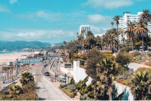
₋Santa Monica (Spanish for 'Saint Monica') is a beachfront city in western Los Angeles County, California, United States. Situated on Santa Monica Bay, it is bordered on three sides by different neighborhoods of the city of Los Angeles: Pacific Palisades to the north, Brentwood on the northeast, West Los Angeles on th e east, Mar Vista on the southeast, and Venice on the south . The 2010 U.S. Census population was 89,736. Due in part to a favorable climate, Santa Monica became a famed resort town by the early 20th century. The city has experienced a boom since the late 1980s through the revitalization of its downtown core, significant job growth and increased tourism. Popular tourists sites include the Santa Monica Pier and Pacific Park.

III.GDP
₋Median household income in Santa Monica, CA is $86,084. Males in Santa Monica, CA have an average income that is 1.26 times higher than the average income of females, which is $57,252. The income inequality in Santa Monica, CA (measured using the Gini index) is 0.5, which is higher than than the national average.
₋Website: https://datausa.io/profile/geo/santa-monica-ca/
IV.Industrial Characteristics
₋The economy of Santa Monica, CA employs 52.7k people. The largest industries in Santa Monica, CA are Professional, Scientific, & Technical Services (10,867 people), Information (6,290 people), and Health Care & Social Assistance (5,550 people), and the highest paying industries are Agriculture, Forestry, Fishing & Hunting ($155,268), Utilities ($113,125), and Finance & Insurance ($99,286).
₋Website: https://datausa.io/profile/geo/santa-monica-ca/
V.Attractions
1.Santa Monica Pier

₋The Santa Monica Pier is a large double-jointed pier at the foot of Colorado Avenue in Santa Monica, California, United States. It contains a small amusement park, concession stands, and areas for views and fishing.
₋Santa Monica has had several piers; however, the current Santa Monica Pier is made up of two adjoining piers that long had separate owners. The long, narrow Municipal Pier opened September 9, 1909, primarily to carry sewer pipes beyond the breakers, and had no amenities. The short, wide adjoining Pleasure Pier to the south, a.k.a. Newcomb Pier, was built in 1916 by Charles I. D. Looff and his son Arthur, amusement park pioneers. Attractions on the Pleasure Pier eventually included the Santa Monica Looff Hippodrome building (which now houses the current carousel and is listed on the National Register of Historic Places), the Blue Streak Racer wooden roller coaster (which was purchased from the defunct Wonderland amusement park in San Diego), the Whip, merry-go-rounds, Wurlitzer organs, and a funhouse.
₋The Philadelphia Toboggan Company built the Carousel, PTC #62, in 1922. It features 44 hand-carved horses. It was rebuilt in 1990 inside the Hippodrome. A calliope provides musical accompaniment.
₋The La Monica Ballroom opened on July 23, 1924. Designed by T.H. Eslick with a Spanish façade and French Renaissance interior, it was the largest dance hall on the west coast, accommodating 5,000 dancers on its 15,000-square-foot (1,400 m2) hard maple floor. Country music star Spade Cooley began broadcasting his weekly television show from the ballroom in 1948, where the program remained until 1954. In the summer of 1955, the Hollywood Autocade opened at the La Monica with one-hundred famous and unusual cars, including Jack Benny's Maxwell and a Rumpler Drop Car. From 1958 until 1962, the ballroom served as a roller skating rink; first as Skater's Ballroom, and later as the Santa Monica Roller Rink, where the speed skating club won many state and regional championships. The La Monica Ballroom was demolished in 1963.
₋The Pleasure Pier thrived during the 1920s but faded during the Great Depression. During the 1930s, most of the amusement park facilities were closed down and its attractions sold off. A breakwater was built in 1934 that provided docking for up to 100 fishing and pleasure boats near the pier.
₋The bridge and entry gate to Santa Monica Pier were built in 1938 by the federal Works Project Administration, and replaced the former grade connection.
₋The Newcomb Pier was privately owned until it was acquired by the city in 1974. During the 1960s and 1970s various plans were proposed that would entail removal of the pier. The most extensive included the construction of an artificial island with a 1500-room hotel. It was approved by the City Council, but citizens formed "Save Santa Monica Bay" to preserve the pier. The order to raze the pier was revoked by the city council in 1973. Within that same year, the Carousel and Hippodrome were sets for the film The Sting.
₋Storms swept away the protective breakwater in 1982. During storms in early 1983, the pier experienced a significant loss. On January 27, there were reported swells of 10-feet during this winter storm. When the storm was over, the lower deck of the pier was destroyed. The City of Santa Monica began repairs on March 1, 1983, when another storm rolled in. A crane which was being used to repair the west end was dragged into the water and acted as a battering ram against the pilings. Over one-third of the Pier was destroyed.
₋On June 18, 2009, the California Office of Environmental Health Hazard Assessment issued a safe eating advisory for any fish caught from Santa Monica Pier to Ventura Harbor due to elevated levels of mercury and PCBs.
₋Address: 200 Santa Monica Pier, Santa Monica, CA 90401, United States
₋Website: https://www.santamonicapier.org/fun
2.Palisades Park

₋Palisades Park is a 26.4-acre park in Santa Monica, California. The park is located along Ocean Avenue on top of an uplifted unconsolidated sedimentary coastal Quaternary terrace with exposed bluffs, offering views of the Pacific Ocean and the coastal mountains. The park extends over 1.5 miles (2.4 km) from the Santa Monica Pier at the south to Adelaide Drive at the north. This long linear park is lined with more than 30 species of plants and trees, including gum, yate, pine, palm, and fig trees.
₋The park includes benches, picnic areas, pétanque courts, restrooms and the historic Santa Monica Camera Obscura. The park has two stone monuments with plaques honoring two noted tree experts, George Hastings and Grace Heintz, who both wrote their own books on the trees of Santa Monica, spanning 5 decades from 1944 to 1989, thereby giving us 5 baseline studies for understanding the history and geography of the urban woodland of not only this park, but also linking to all the trees of Santa Monica and neighoring portions of Los Angeles, between and alongside streets, and embracing the trees also at cemeteries, schools, colleges, and businesses. A bust of Arcadia Bandini is located in the park's rose garden. A nearby wood sculpture entitled Gestation III is notable because of its alignment with the setting sun on the winter solstice. A distinctive Native American Totem Pole donated to the City in 1926 is located at the park's northern end. Cannons are on display at the park's southern end. Near the California Incline, a sculpture named Overlook Beacon evokes a sailing ship with mast and wooden deck.
₋A Santa Monica City Ordinance prohibits smoking in any City park. Barriers discourage visitors from approaching the cliffs, which are prone to erosion and landslides. Use of the park by fitness instructors has generated some controversy.
₋Address: Ocean Ave, Santa Monica, CA 90401, United States
₋Phone: +1 310-458-8300
₋Website: https://www.santamonica.com/what-to-do/palisades-park/
3.Tongva Park

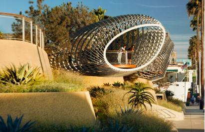
₋Tongva Park is a 6.2-acre park in Santa Monica, California. The park is located just south of Colorado Avenue, between Ocean Avenue and Main Street. The park is named after the indigenous Tongva people, who have lived in the Los Angeles area for thousands of years.
₋The park includes an amphitheater, playground, garden, fountains, picnic areas, and restrooms. An overlook offers scenic views of the Pacific Ocean and of the Santa Monica Pier.
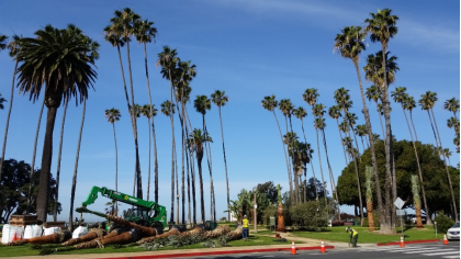
₋Notable trees in the park include "Morty," a large Moreton Bay Fig Tree (Ficus macrophylla) and the "Three Amigos," three Rusty Fig (Ficus rubiginosa) trees each weighing over 100 tons. The "Three Amigos" were moved 550 ft from their prior location at the intersection of Main Street and Olympic Drive and replanted in the park.
₋A Santa Monica City Ordinance prohibits smoking in any City park.
₋The park was dedicated on October 13th, 2013.
₋Address: 1615 Ocean Ave, Santa Monica, CA 90401, United States
₋Phone: +1 310-458-8310
₋Website: http://tongvapark.smgov.net/
VI.History
₋Santa Monica was inhabited by the Tongva people. Santa Monica was called Kecheek in the Tongva language. The first non-indigenous group to set foot in the area was the party of explorer Gaspar de Portolà, who camped near the present-day intersection of Barrington and Ohio Avenues on August 3, 1769. Named after the Christian saint Monica, there are two different accounts of how the city's name came to be. One says it was named in honor of the feast day of Saint Monica (mother of Saint Augustine), but her feast day is May 4. Another version says it was named by Juan Crespí on account of a pair of springs, the Kuruvungna Springs (Serra Springs), that were reminiscent of the tears Saint Monica shed over her son's early impiety.
₋Following the Mexican–American War, Mexico signed the Treaty of Guadalupe Hidalgo, which gave Mexicans and Californios living in state certain unalienable rights. US government sovereignty in California began on February 2, 1848.
₋In the 1870s, the Los Angeles and Independence Railroad connected Santa Monica with Los Angeles, and a wharf out into the bay. The first town hall was an 1873 brick building, later a beer hall, and now part of the Santa Monica Hostel. It is Santa Monica's oldest extant structure. By 1885, the town's first hotel was the Santa Monica Hotel.
₋Amusement piers became popular in the first decades of the 20th century and the extensive Pacific Electric Railroad brought people to the city's beaches from across the Greater Los Angeles Area.
₋Around the start of the 20th century, a growing population of Asian Americans lived in and around Santa Monica and Venice. A Japanese fishing village was near the Long Wharf while small numbers of Chinese lived or worked in Santa Monica and Venice. The two ethnic minorities were often viewed differently by White Americans who were often well-disposed towards the Japanese but condescending towards the Chinese. The Japanese village fishermen were an integral economic part of the Santa Monica Bay community.
₋Donald Wills Douglas, Sr. built a plant in 1922 at Clover Field (Santa Monica Airport) for the Douglas Aircraft Company. In 1924, four Douglas-built planes took off from Clover Field to attempt the first aerial circumnavigation of the world. Two planes returned after covering 27,553 miles (44,342 km) in 175 days, and were greeted on their return September 23, 1924, by a crowd of 200,000. The Douglas Company (later McDonnell Douglas) kept facilities in the city until the 1960s.
₋The Great Depression hit Santa Monica deeply. One report gives citywide employment in 1933 of just 1,000. Hotels and office building owners went bankrupt. In the 1930s, corruption infected Santa Monica (along with neighboring Los Angeles). The federal Works Project Administration helped build several buildings, most notably City Hall. The main Post Office and Barnum Hall (Santa Monica High School auditorium) were also among other WPA projects.
₋Douglas's business grew with the onset of World War II, employing as many as 44,000 people in 1943. To defend against air attack, set designers from the Warner Brothers Studios prepared elaborate camouflage that disguised the factory and airfield. The RAND Corporation began as a project of the Douglas Company in 1945, and spun off into an independent think tank on May 14, 1948. RAND acquired a 15-acre (61,000 m2) campus between the Civic Center and the pier entrance.
₋The completion of the Santa Monica Freeway in 1966 decimated the Pico neighborhood that had been a leading African American enclave on the Westside.
₋Beach volleyball is believed to have been developed by Duke Kahanamoku in Santa Monica during the 1920s.
VII.Other Information
₋Transportation
₋Bicycles
₋Santa Monica has a bike action plan and launched a bicycle sharing system in November 2015. The city is traversed by the Marvin Braude Bike Trail. Santa Monica has received the Bicycle Friendly Community Award (Bronze in 2009, Silver in 2013) by the League of American Bicyclists. Local bicycle advocacy organizations include Santa Monica Spoke, a local chapter of the Los Angeles County Bicycle Coalition. Santa Monica is thought to be one of the leaders for bicycle infrastructure and programming in Los Angeles County although cycling infrastructure in Los Angeles County in general remains very poor compared to other major cities.
₋In terms of number of bicycle accidents, Santa Monica ranks as one of the worst (#2) out of 102 California cities with population 50,000–100,000, a ranking consistent with the city's composite ranking. In 2007 and 2008, local police cracked down on Santa Monica Critical Mass rides that had become controversial, putting a damper on the tradition.
₋Scooters
₋In August 2018, Santa Monica issued permits to Bird, Lime, Lyft, and Jump Bikes to operate dockless scooter-sharing systems in the city.
₋Motorized vehicles
₋The Santa Monica Freeway (Interstate 10) begins in Santa Monica near the Pacific Ocean and heads east. The Santa Monica Freeway between Santa Monica and downtown Los Angeles has the distinction of being one of the busiest highways in all of North America. After traversing the Greater Los Angeles area, I-10 crosses seven more states, terminating at Jacksonville, Florida. In Santa Monica, there is a road sign designating this route as the Christopher Columbus Transcontinental Highway. State Route 2 (Santa Monica Boulevard) begins in Santa Monica, barely grazing State Route 1 at Lincoln Boulevard, and continues northeast across Los Angeles County, through the Angeles National Forest, crossing the San Gabriel Mountains as the Angeles Crest Highway, ending in Wrightwood. Santa Monica is also the western terminus of Historic U.S. Route 66. Close to the eastern boundary of Santa Monica, Sepulveda Boulevard reaches from Long Beach at the south, to the northern end of the San Fernando Valley. Just east of Santa Monica is Interstate 405, the San Diego Freeway, a major north–south route in Los Angeles and Orange counties.
₋The City of Santa Monica has purchased the first ZeroTruck all-electric medium-duty truck. The vehicle will be equipped with a Scelzi utility body, it is based on the Isuzu N series chassis, a UQM PowerPhase 100 advanced electric motor and is the only US built electric truck offered for sale in the United States in 2009.
₋Bus
₋The city of Santa Monica runs its own bus service, the Big Blue Bus, which also serves much of West Los Angeles and the University of California, Los Angeles (UCLA). A Big Blue Bus was featured prominently in the action movie Speed.
₋The city of Santa Monica is also served by the Los Angeles County Metropolitan Transportation Authority's (Metro) bus lines. Metro also complements Big Blue service, as when Big Blue routes are not operational overnight, Metro buses make many Big Blue Bus stops, in addition to MTA stops.
₋Light rail
₋Design and construction on the 6.6-mile extension (10.6 km) of the Expo Line from Culver City to Santa Monica started in September 2011, with service beginning on May 20, 2016. Santa Monica Metro stations include 26th Street/Bergamot, 17th Street/Santa Monica College, and Downtown Santa Monica. Travel time between the downtown Santa Monica and the downtown Los Angeles termini is approximately 47 minutes.
₋Historical aspects of the Expo line route are noteworthy. It uses the former Los Angeles region's electric interurban Pacific Electric Railway's right-of-way that ran from the Exposition Park area of Los Angeles to Santa Monica. This route was called the Santa Monica Air Line and provided electric-powered freight and passenger service between Los Angeles and Santa Monica beginning in the 1920s. Passenger service was discontinued in 1953, but diesel-powered freight deliveries to warehouses along the route continued until March 11, 1988. The abandonment of the line spurred future transportation considerations and concerns within the community, and the entire right-of-way was purchased from Southern Pacific by Los Angeles Metropolitan Transportation Authority. The line was built in 1875 as the steam-powered Los Angeles and Independence Railroad to bring mining ore to ships in Santa Monica harbor and as a passenger excursion train to the beach.
₋Subway
₋Since the mid-1980s, various proposals have been made to extend the Purple Line subway to Santa Monica under Wilshire Boulevard. There are no current plans to complete the "subway to the sea," an estimated $5 billion project.
₋Airport and ports
₋The city owns and operates a general aviation airport, Santa Monica Airport, which has been the site of several important aviation achievements. Commercial flights are available for residents at LAX, a few miles south of Santa Monica.
₋Like other cities in Los Angeles County, Santa Monica is dependent upon the Port of Long Beach and the Port of Los Angeles for international ship cargo. In the 1890s, Santa Monica was once in competition with Wilmington, California, and San Pedro for recognition as the "Port of Los Angeles" (see History of Santa Monica, California).
VIII.Contact Information
₋Government
Type: Council–manager
Mayor: Kevin McKeown (D)
₋City Hall
TEL: (310) 458-8411
City Hall Hours: santamonica.gov/hours
₋Website: https://www.smgov.net/Main/Contact_Us.aspx
