Chandler, Arizona 作者: 来源: 发布时间:2021-07-19
I.Population and Area
₋Area
Land: 65.34 sq mi (169.24 km2)
₋Population
Total: 236,123
Density: 4,001.06/sq mi (1,544.81/km2)
II.Natural Geography
Beach & City View
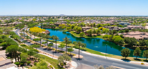
₋Chandler is a city in Maricopa County, Arizona, United States, and a suburb of the Phoenix, Arizona, Metropolitan Statistical Area (MSA). It is bordered to the north and west by Tempe, to the north by Mesa, to th e west by Phoenix, to the south by the Gila River Indian Community, and to the east by Gilbert. As of 2019, the population was estimated at 261,165 according to the United States Census Bureau.
₋Transportation
₋Addressing
Most incorporated portions of Chandler, along with other East Valley cities Gilbert, Mesa, and Tempe, have their own addressing system distinct from the city of Phoenix and Maricopa County. The north–south meridian is Arizona Avenue, also known as State Route 87. Commonwealth Avenue, t wo blocks south of Chandler Boulevard, is the east–west baseline. With the significant exception of the stretch of the city from Chandler Boulevard to Ray Road, address numbers follow in mile-long increments of 1000 along the grid. Modern remnants of county addressing (which corresponds to the city of Phoenix system) from the city's rural agrarian days can be found in some neighborhood street names (90th Place, 132nd Street) and county islands surrounded by the city proper.
₋Airports
Chandler Municipal Airport is a two-runway general aviation facility located in the heart of the city south of Loop 202. Gila River Memorial Airport in the Gila River Indian Community may serve the city in the future. In western Chandler, Stellar Airpark is a privately owned airport that is open to the public. The nearest commercial airport to downtown Chandler is Phoenix-Mesa Gateway Airport located roughly 10 miles (20 km) to the east, which offers service to 35 cities as of July 2015. For international and regional travel, most area residents continue to use Phoenix Sky Harbor International Airport, 20 miles (30 km) from downtown Chandler.
₋City bus
Chandler has very limited bus service compared with other Valley Metro cities of similar size; it currently ranks sixth in total ridership behind Phoenix, Tempe, Mesa, Scottsdale, and Glendale. Most local routes dead-end a few miles from the city or have further limited service within its borders. Currently, two express bus routes leave from the city near downtown, and a new park and ride facility was recently completed further south. Faced with increasing congestion, the land-locked city is pursuing transportation alternatives, including enhancement of the local bus system. This goal has partially been achieved through Proposition 400, which converts transit funding from city-based to county-based. The result has been increased frequencies on routes 72, 81, 96 (since July 28, 2008), 112, and 156, as well as Sunday bus service on the 72, 112, and 156. However, other routes have yet to be converted to "supergrid" status.
III.GDP
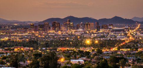
₋The average salary in Chandler, AZ is $69k. Trends in wages increased by 0.2 percent in Q1 2020. The cost of living in Chandler, AZ is 5 percent higher than the national average. The most popular occupations in Chandler, AZ are Process Engineer, Software Engineer, and Mechanical Engineer which pay between $42k and $119k per year. The most popular employers in Chandler, AZ are Intel Corporation, Microchip Technology, Inc, and Orbital ATK.
₋Website: https://www.payscale.com/research/US/Location=Chandler-AZ/Salary
IV.Industrial Characteristics
₋Computer chip manufacturer Intel has an influential role in city growth strategies with four locations in the municipal area, including its first factory to be designated "environmentally sustainable" under current Leadership in Energy and Environmental Design (LEED) criteria. Other high-technology manufacturing firms have partnerships with the local government, their operations employing approximately twenty-five percent of non-government workers in 2007. Although per capita employment growth in the sector has been in decline in Arizona since 2000, semiconductor and other electronic component manufacturing was largely unaffected; a series of customized grants for the training of net new employees, incorporating the Phoenix urbanized area (twenty-seven thousand workers now commute to work in other communities), resulted in a larger market share of (Californian) industry.
₋Since 2003, more than 2,900 jobs and investments totalling $3 billion have been created along the Price and Santan freeways, between Arizona Avenue and Gilbert Road in the so-called South Arizona Avenue Corridor. Three shopping malls provide a "strong attraction" to such an open-ended, high exposure trade area: the 1,300,000-square-foot (120,000 m2) Chandler Fashion Center, opened in 2001, has spurred on several courts and laneway developments. In the southern end of the Corridor, Wal-Mart is expected to draw business from as far south as Hunt Highway, bringing with it a "large consumer population" which will improve "the image and perception of the area" in the mindset of many Greater Phoenix residents and state commercial retailers. The northern portion is "attractive and possesses the historic character" for success, which "can be grown to the south".
₋Companies headquartered in Chandler include Infusionsoft, Microchip, and Rogers. Bashas' headquarters is located in a county island surrounded by Chandler.
V.Attractions
1.Veterans Oasis Park
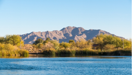
₋With scenic trails, fishing, birding, horseback riding, loads of picnic areas and an outdoor amphitheater, Veterans Oasis Park has something for everyone outdoors. Its 113 acres, including 78 acres of which are designed for groundwater recharge and wetlands, serve as a habitat for diverse Sonoran Desert plants and wildlife and the City's Environmental Education Center.
₋Address: 4050 E Chandler Heights Rd, Chandler, AZ 85249, United States
₋Phone: +1 480-782-2890
₋Website: https://www.chandleraz.gov/explore/chandler-parks/guide/veterans-oasis-park
2.Arizona Railway Museum
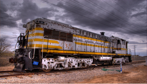
₋The Arizona Railway Museum (reporting mark AZMX) is a railroad museum located in Chandler, Arizona.
₋It was founded and incorporated as a non-profit organization in 1983. It is dedicated to the railroads of Arizona and the Southwestern United States. It has an extensive collection railroad rolling stock and artifacts. Two of items on display are listed in the National Register of Historic Places, they are the "Southern Pacific Railroad Locomotive No. SP 2562" and "Tender No. 8365" and the "Railroad Steam Wrecking Crane and Tool Car".
₋Address: 330 E Ryan Rd, Chandler, AZ 85286, United States
₋Phone: +1 480-821-1108
₋Website: https://www.azrymuseum.org/
3.Makutu's Island
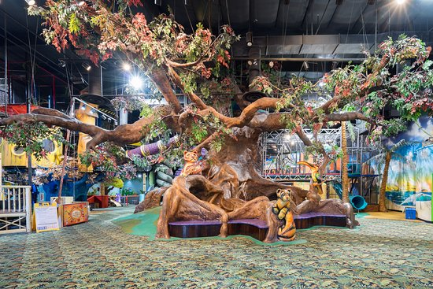
₋Makutu’s Island was called Club Disney - is an evergreen lush, exciting indoor “island” with towering trees, climbs, mysterious caves, a "bungee jump", a zip track, an arcade, a café, a special toddler zone and so much more. Our admission price includes ALL DAY fun (and it is not a trampoline park or bounce jungle that you need to pay by the hour)
₋Makutu's Island has no affiliation with Disney. Even though the structure and design were done by Disney, it is now re-themed as Makutu's Island with our cute characters that include the jaguar cub Makutu and his friends. Current play structure is the end result of Disney CEO of the time Michael Eisner's vision who moved forward with an idea of having local entertainment based on Disney brands in suburban areas. Club Disney was a unique tropical jungle themed as a regional children's play center concept operated by Disney Regional Entertainment. The indoor center was designed for families with various play attractions, gift shops, snack bars and place to host birthday parties. Disney later shut down the concept and moved it to the malls. That is when the current Makutu's Island was born.
₋The centerpiece of Makutu’s Island is a magnificent indoor tree. The tree is filled with tunnels, tubes, mole-holes, and slides. Our facility offers hours of fun and adventure.
₋The “snake” slide is a sure thrill as it starts on the forth level and winds more than 35 feet around the outside of the tree to it's base.
₋After exploring the tree, many of guests find themselves in one of the three adjoining play structures including the Blue Fantasy Tree, Pirates Cove and Palm Slide. Less rigorous than the big oak tree, and perfect for the less-experienced island travelers this area features tunnels, caves, and a zip tracker!
₋Our characters are - Makutu, the friendly jaguar cub; Kiki, the well-mannered koala (Cafe is Kiki's cafe); Oscar, the humorous alligator (Toddler area is Oscar's Swamp); Captain Max, the wise parrot (Bungee is called Captain Max Bungee). We are proud to have hosted 1000's of birthday parties, 100's of field trips and fundraisers. We refer to ourselves as islands and would love to host your family and build great memories.
₋Address: 6919 W Ray Rd, Chandler, AZ 85226, United States
₋Phone: +1 480-344-3740
₋Website: https://www.makutusisland.com/
VI.History
₋In 1891, Dr. Alexander John Chandler, the first veterinary surgeon in Arizona Territory, settled on a ranch south of Mesa, studying irrigation engineering. By 1900, he had acquired 18,000 acres (73 km2) of land, and began drawing up plans for a townsite on what was then known as the Chandler Ranch. The townsite office opened on May 16, 1912.
₋[Soon after celebrating Chandler's Centennial on May 17, 2012, Chandler Museum staff discovered that the City celebrated the wrong date. In May 1912, the Chandler Arizonan newspaper had erroneously published the founding day as May 17, and through the years residents had misremembered the correct date, which was Thursday, May 16, 1912.
₋The original townsite was bounded by Galveston Street on the north, Frye Road on the south, Hartford Street on the west, and Hamilton Street on the east. By 1913, a town center had become established, featuring the Hotel San Marcos, which also had the first grass golf course in the state. Chandler High School was established in 1914. Chandler incorporated on Feb. 16, 1920, after 186 residents petitioned the Maricopa County Board of Supervisors to approve incorporation. Town founder, Dr. A.J. Chandler, was chosen as the president of the first Town Council and the town's first mayor.
₋Most of Chandler's economy was successfully sustained during the Great Depression (though the Depression was to blame for the cancellation of a second San Marcos hotel), but the cotton crash a few years later had a much deeper impact on the city's residents. Later, the founding of Williams Air Force Base in 1941 led to a small surge in population, but Chandler still only held 3,800 people by 1950. By 1980, it had grown to 30,000, and it has since paced the Phoenix metropolitan area's high rate of growth, with vast suburban residential areas swallowing former agricultural plots. Some of this growth was fueled by the establishment of manufacturing plants for communications and computing firms such as Microchip, Motorola and Intel.
₋Since the early 1990s, the City of Chandler has experienced exponential growth, ranking among the fastest-growing municipalities in the country. Nearly 100,000 homes dot the landscape today and the population has surged to more than 238,000 residents as of 2010. The heart of Chandler remains its revitalized historic downtown, which includes the award-winning Chandler City Hall and the Chandler Center for the Arts. In 2010, Chandler was named as an All-America City by the National Civic League. Chandler was the only Arizona winner for the 61st annual awards.[citation needed] In 2012, the city celebrated its 100th birthday. Centennial events were planned throughout the year.
VII.Other Information
₋Infrastructure
₋Freeways
₋Main article: Metropolitan Phoenix Freeways
₋Chandler is served by three limited access highways:
Loop 202, the Santan Freeway, completed through the city in 2006, cuts through the midsection of the city along the Pecos Road alignment.
Loop 101, the Price Freeway, was completed in 2001, dividing West Chandler from the rest of the city. A majority of the city's employment, over 10,000 people as of 2007, are along the city's Price Road Corridor. Air Products' industrial pipelines located there are unique to the metropolitan area. South of Pecos, the freeway borders the Gila River Indian Community.
Interstate 10 is the city's westernmost border. Located on the other side is the Phoenix neighborhood of Ahwatukee.
₋Railroads
₋Chandler is served by two single-track branch lines of the Union Pacific Railroad. One generally traverses the Kyrene Road alignment and currently dead-ends at the Lone Butte Industrial Park. The other runs east of Arizona Avenue and dead-ends near Sacaton, Arizona. Commuter rail service on these lines is under study as of 2007.
₋Light rail
₋No light rail lines have been approved in the city, although high-capacity corridors including light rail have been identified in other regional and local plans. City officials joined the regional light rail authority, Valley Metro Rail, in 2007, expecting service perhaps in 2020. Potential high capacity transit corridors that have been identified in the past include Rural Road, Arizona Avenue, and Chandler Boulevard. The Chandler General Plan 2016 does not authorize light rail or any form of high capacity transit. A separate process for any consideration of light rail as the mode of transit may occur in the years to come. The language in the General Plan 2016 is to identify that options remain available in the future for the city as it continues analyzing transit within the high-capacity transit corridors.
VIII.Contact Information
₋Government
Type: Council-Manager
Mayor: Kevin Hartke
₋City Hall
Address: 175 S Arizona Ave, Chandler, AZ 85225, United States
Phone: +1 480-782-2180
₋Website: https://www.chandleraz.gov/
