West Yellowstone, Montana 作者: 来源: 发布时间:2021-01-29
I. Population and Area
₋ Area
Land: 2.1 km2 (0.8 sq mi)
₋ Population (2018)
Total: 1,382
Density: 610/km2 (1,600/sq mi)
II. Natural Geography

Town Overview
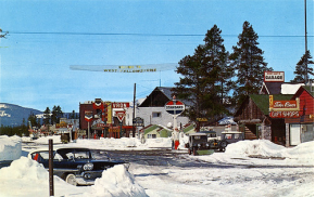
₋ West Yellowstone is a town in Gallatin County, Montana, United States, adjacent to Yellowstone National Park. The population was 1,271 at the 2010 census. West Yellowstone is served by Yellowstone Airport. It is part of the Bozeman, MT Micropolitan Statistical Area.
₋ West Yellowstone offers lodging, gift shops, and other services to travelers visiting nearby Yellowstone National Park.
₋ Spring is a time of change and renewal in West Yellowstone, bringing wildlife newborns, bear sightings, and beautiful scenery to photograph.
₋ Summer days provide visitors unlimited access to explore and play in the splendor of the high country. You can fish blue-ribbon trout streams, hike in pristine wilderness, experience real western horseback riding, go whitewater rafting, or mountain bike on hundreds of miles of singletrack and forest service roads.
₋ Fall brings spectacular scenery and the annual elk mating season where huge bull elk battle for their harems with eerie, echoing bugles.
₋ Winter brings an average annual snowfall of 143 inches, which means endless adventures in cross-country skiing, ice fishing, sled dog tours, and much more. Enjoy snowcoach or snowmobile tours into Yellowstone National Park from West Yellowstone—the only daily winter entrance into the park. West Yellowstone, your outdoor playground for every season.
III. GDP
₋ The average income of a West Yellowstone resident is $25,243 a year. The US average is $28,555 a year.
₋ The Median household income of a West Yellowstone resident is $39,097 a year. The US average is $53,482 a year.
₋ Website: https://www.bestplaces.net/economy/city/montana/west_yellowstone
IV. Industrial Characteristics
₋ Employment by Occupations
From 2016 to 2017, employment in West Yellowstone, MT declined at a rate of -0.746%, from 670 employees to 665 employees.
The most common job groups, by number of people living in West Yellowstone, MT, are Management Occupations (106 people), Food Preparation & Serving Related Occupations (93 people), and Sales & Related Occupations (81 people). This chart illustrates the share breakdown of the primary jobs held by residents of West Yellowstone, MT.
The highest paid jobs held by residents of West Yellowstone, MT, by median earnings, are Construction & Extraction Occupations ($35,278), Management, Business, & Financial Occupations ($33,594), and Management Occupations ($33,203).
₋ Employment by Industries
From 2016 to 2017, employment in West Yellowstone, MT declined at a rate of -0.746%, from 670 employees to 665 employees.
The most common employment sectors for those who live in West Yellowstone, MT, are Accommodation & Food Services (253 people), Retail Trade (90 people), and Transportation & Warehousing (53 people). This chart shows the share breakdown of the primary industries for residents of West Yellowstone, MT, though some of these residents may live in West Yellowstone, MT and work somewhere else. Census data is tagged to a residential address, not a work address.
The most common industries in West Yellowstone, MT, by number of employees, are Accommodation & Food Services (253 people), Retail Trade (90 people), and Transportation & Warehousing (53 people).
The highest paying industries in West Yellowstone, MT, by median earnings, are Construction ($35,972), Transportation & Warehousing, & Utilities ($33,500), and Transportation & Warehousing ($33,125).
₋ Website: https://datausa.io/profile/geo/west-yellowstone-mt#economy
V. Attractions
1. Grizzly and Wolf Discovery Center

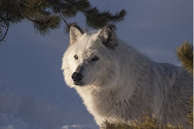
₋ Watch grizzly bears and gray wolves in natural habitats at Grizzly and Wolf Discovery Center. This nonprofit zoo specializes in its focus on these two particular animals, which are part of the Yellowstone ecosystem. The center also distinguishes itself from many other zoos by hosting only animals that are not able to survive in the wild. The zoo began as a sanctuary for bears that were unable to continue living in the wild in 1993. Wolves were added to the sanctuary in 1996. The center is now connected with Yellowstone National Park and hosts several of the park's programs. Using our online itinerary creator, West Yellowstone attractions like Grizzly and Wolf Discovery Center can form part of a personalized travel itinerary.
₋ Address: 201 South Canyon, West Yellowstone, MT 59758
₋ TEL: 406-646-7001
2. Yellowstone River

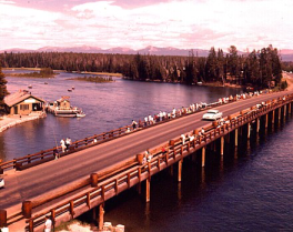
₋ The Yellowstone River is a tributary of the Missouri River, approximately 692 miles (1,114 km) long, in the western United States. Considered the principal tributary of the upper Missouri, the river and its tributaries drain a wide area stretching from the Rocky Mountains in the vicinity of Yellowstone National Park across the mountains and high plains of southern Montana and northern Wyoming.
₋ Yellowstone Lake to Yellowstone Falls
The river inside Yellowstone National Park provides accessible flat water fishing and abundant Yellowstone cutthroat trout. The portion of the river through the Hayden Valley is closed all year long, but the rest is accessible and easily wadable. No floating is allowed. Numerous insect hatches occur following the opening of the river on July 15 providing anglers the opportunity to try numerous artificial flies including Pale Morning Duns, Green Drakes, Gray Drakes, Caddis and salmonflies.
₋ Grand Canyon of the Yellowstone and Black Canyon of the Yellowstone
The canyon reaches inside Yellowstone National Park are accessible only by hiking or horseback. The river here is usually quite swift, with sheer canyon walls in spots. Below Knowles Falls, about four miles upstream from Gardiner, anglers will find browns and whitefish in addition to the rainbows and cutthroat trout.
₋ Gardiner to Yankee Jim Canyon
This section of the Yellowstone holds a good population of medium-sized rainbow and cutthroat trout, with a few big browns as well. The first half of this section from Gardiner to the bridge at Corwin Springs is mostly fast water, with some class II and III white water. From Corwin Springs to Yankee Jim Canyon, the river flattens out substantially and gives the angler more time to cast to fish along the banks.
₋ Yankee Jim Canyon
Yankee Jim Canyon is the Yellowstone’s best white water, with several major rapids. Steep canyon walls make it a difficult stretch to fish. Because of the potential danger in floating the Canyon, many commercial fishing guides do not float this stretch, though recreational floaters are common.
₋ Tom Miner Bridge to Emigrant
From the Tom Miner Bridge (or the Carbella access just downstream) down to Point of Rocks, there is some excellent water, lots of fast pocket water with several nice pools. Once the river reaches the Point of Rocks, the gradient decreases substantially and the river turns into slower, longer pools.
₋ Emigrant to Mallard’s Rest
Just downstream from Emigrant is Grey Owl, one of the best fishing access points on the river. From here down to Mallard's Rest there is a pleasant mix of big pools and large browns and rainbows.
₋ Mallard’s Rest to Carter’s Bridge
This section of river known as Paradise Valley provides some of the most spectacular scenery on the Yellowstone, along with some of the best fishing. The scenery is dominated by the Absaroka Mountains to the east and the Gallatin Mountains to the west. Along this stretch numerous spring creeks flow into the river, many of which are blue ribbon trout streams in their own right, such as DePuy Spring Creek. Rainbows dominate this part of the river, but browns can be found here also.
₋ Carter’s Bridge to Highway 89 Bridge
Because the Yellowstone flows right through Livingston between these points, this is known as the "town stretch". Given the presence of the upstream spring creeks for spawning, this reach of fast water is ideal habitat for rainbows which make up most of the population here. The use of a drift boat is the best way to access this stretch, though there are some good access points for walking and wading as well.
3. Earthquake Lake (Quake Lake)

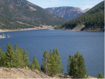
₋ Quake Lake (officially Earthquake Lake) is a lake in southwestern Montana in the United States. It was created after an earthquake struck on August 17, 1959, killing 28 people. Today, Quake Lake is 190 feet (58 m) deep and 6 miles (9.7 km) long. US 287 follows the lake and offers glimpses of the effects of the earthquake and landslide, and a visitor center is just off the road. The lake is mostly within Gallatin National Forest.
₋ The earthquake measured 7.5 on the Richter magnitude scale (revised by USGS to 7.3) and caused an 80-million ton landslide, which formed a landslide dam on the Madison River. The earthquake was the most powerful to hit the state of Montana in historic times. The landslide traveled down the south flank of Sheep Mountain, at an estimated 100 miles per hour (160 km/h), killing 28 people who were camping along the shores of Hebgen Lake and downstream along the Madison River. Upstream the faulting caused by the earthquake forced the waters of Hebgen Lake to shift violently. A seiche, a wave effect created by wind, atmospheric pressure, or seismic activity on water, crested over Hebgen Dam, causing cracks and erosion.
₋ The earthquake created fault scarps up to 20 ft (6.1 m) high in the area near Hebgen Lake and the lake bottom itself dropped the same distance. 32,000 acres (130 km2) of the area near Hebgen Lake subsided more than 10 ft (3.0 m). Several geysers in the northwestern sections in Yellowstone National Park erupted and numerous hot springs became temporarily muddied.
₋ Within the immediate vicinity of the earthquake and resultant landslide, a few dozen cabins and homes were destroyed. Overall damages to buildings and roads were minor with damage costs placed at 11 million dollars in 1959. Aftershocks up to 6.5 on the Richter magnitude scale continued for several months. At the time, the quake was the second largest to occur in the continental US during the 20th century.
VI. History
- Founded in June 1908 when the Oregon Short Line Railroad was completed, the town's name changed several times until West Yellowstone was settled upon in 1920.
- Before West Yellowstone was a town, it was simply known as Riverside, Boundary or West End, referring to Yellowstone Park's western entrance. The town was officially one of the entrances to the park in 1907 (when it was first settled), although it didn't get the title of West Yellowstone until 1920.
- West Yellowstone is the gateway community that serves the West Entrance of Yellowstone National Park. The town traces its beginning to the arrival of the Union Pacific Railroad that was built specifically to provide passenger service for Yellowstone visitors. Learn about the fascinating history of this town starting with “A Rough, Dusty Ride to Yellowstone.”
VII. Other Information
₋ Layout
The D Parkway road roughly separates the town into residential and commercial areas. South of D Parkway is mainly a business/commercial area, while northward is a residential area of homes and apartments. The area north of D Parkway is known to locals as the "Madison Addition.
₋ Transportation
The West Yellowstone Airport, a mainly summer-operating airport, is to the north of town.
U.S. Route 20 and U.S. Route 191 pass through the town.
The Union Pacific Railroad historically operated the Butte Special, (29/30) which linked with a coordinated train, the Yellowstone Special, (35/36) which ran from Pocatello, Idaho to West Yellowstone. The two trains ran linked from Pocatello to Idaho Falls, where the latter train split off for West Yellowstone. Service ended in 1971.
VIII. Contact Information
₋ Government
Mayor: Jerry Johnson
Town Manager: Daniel Sabolsky
₋ Address:
440 Yellowstone Ave, West Yellowstone, MT 59758, United States
₋ Phone: 406-646-7795
