Radium Hot Springs, British Columbia 作者: 来源: 发布时间:2021-12-08
I.Population and Area
-Area
•Land:6.34 km2 (2.45 sq mi)
•Elevation: 808 m (2,651 ft)
-Population (2016)
-Total: 776
-Density: 122.4/km2 (317/sq mi)
II.Natural Geography (environment and resources)
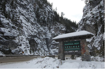
-Radium Hot Springs, informally and commonly called Radium, is a village of 776 residents situated in the East Kootenay region of British Columbia. The village is named for the hot springs located in the nearby Kootenay National Park. From Banff, Alberta, it is accessible via Highway 93.
-The hot springs were named after the radioactive element when an analysis of the water showed that it contained small traces of radon which is a decay product of radium. The radiation dosage from bathing in the pools is inconsequential; approximately 0.13 millirems (1.3 μSv) from the water for a half-hour bathing, around ten times average background levels. The air concentration of radon is about 23 picocuries (0.85 Bq) per litre which is higher than the level (4 picocuries per litre) at which mitigation is necessary at residences; but is also inconsequential (about 0.7 mrem or 7.0 μSv for a half-hour bathing) from a dose impact perspective.
-Radium is located 16 km north of the tourist town of Invermere, and 105 km south of Golden, British Columbia. It is located at the junction of Highway 95 and Highway 93, in the Columbia River valley, between the river and Kootenay National Park.
-Wildlife in the area includes mule deer, grizzly bears, black bears, mountain goats and Rocky Mountain bighorn sheep.
III.ECONOMY
-Average Hourly Rate in Radium Hot Springs, British Columbia: C$21.95
-Website: https://www.payscale.com/research/CA/Location=Radium-Hot-Springs-British-Columbia/Salary
IV.Industrial Characteristics
-Business Resources
•Website: https://radiumhotsprings.ca/village-business/business-resources/
•The following resources are available to both new and existing business owners to help them build capacity, secure loans, develop skills, and reach their fullest potential.
-Small Business BC
•https://smallbusinessbc.ca/
•Small Business BC helps British Columbia’s entrepreneurs grow successful and sustainable businesses through expert business advisors, educational services, easy-to-use free resources and engaging community events.
-Women’s Enterprise Centre
•https://www.womensenterprise.ca/
•Women’s Enterprise Centre is a non-profit organization devoted to helping BC women start, lead and grow their own business. Women’s Enterprise Centre provides business loans up to $150K, with access to an additional $100K through a partnership with BDC.
V.Attractions
1.Sinclair Canyon
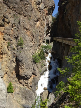
-Sinclair Canyon is one of several significant geological phenomena of Kootenay National Park in British Columbia. The canyon is characterized by almost perpendicular, iron red-colored cliffs that were once shaped by Sinclair Creek. Sinclair Canyon can be visited via the 3 km long and easily accessible Juniper Trai .
-TEL: (250) 347-9505
2.Kootenay National Park
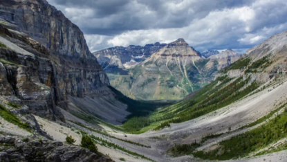
-Kootenay National Park is a national park located in southeastern British Columbia, and is one component of the Canadian Rocky Mountain Parks World Heritage Site. The park consists of 1,406 km2 (543 sq mi) of the Canadian Rockies, including parts of the Kootenay and Park mountain ranges, the Kootenay River and the entirety of the Vermilion River. While the Vermillion River is completely contained within the park, the Kootenay River has its headwaters just outside the park boundary, flowing through the park into the Rocky Mountain Trench, eventually joining the Columbia River. It ranges in elevation from 918 m (3,012 ft) at the southwestern park entrance, to 3,424 m (11,234 ft) at Deltaform Mountain. Initially called "Kootenay Dominion Park", the park was created in 1920 as part of an agreement between the province of British Columbia and the Canadian federal government to build a highway in exchange for title to a strip of land, approximately 8 km (5.0 mi) on either side of the 94 km route, the Banff-Windermere Highway, to be used solely for park purposes. While the park is open all year, the major tourist season lasts from June to September. Most campgrounds are open from early May to late September, while limited winter camping is available only at the Dolly Varden campground.
-The Kootenay National Park is one of seven contiguous parks that form the Canadian Rocky Mountain Parks World Heritage Site. The Continental Divide is the boundary between the Kootenay and Banff National Park boundary, as well as the BC-Alberta provincial border. To the northwest, the watershed boundary between the Vermillion River and the Kicking Horse River is the park boundary between the Kootenay and Yoho National Park. The Mount Assiniboine Provincial Park also borders the Kootenay National Park. Jasper National Park, Mount Robson Provincial Park and Hamber Provincial Park make up the remainder of the World Heritage Site but do not share a boundary with Kootenay National Park.
-TEL: 1-250-347-9505
• 1-888-773-8888
-Email: Kootenay.Info@pc.gc.ca
-Website: ParksCanada.ca/Kootenay
3.Olive Lake
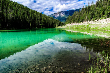
-Olive Lake is a popular day use park often visited by many when traveling along Highway #93 in the Kootenay National Park of British Columbia, Canada.
-The national park is a popular destination for many who seek adventure, wildlife and sightseeing when visiting the village of Radium Hot Springs.
-The day use park rests on the shores of Olive Lake. It is a quiet spot in the mountains settled around an alpine lake near the Sinclair Pass Summit.
-For many travelers the day use park doubles as a rest stop. There are pit toilets (one wheelchair accessible), picnic tables and a picnic shelter on site. There is no overnight camping facilities on the lake.
-Olive Lake is a good place to quickly stretch your legs. Picnicking, wildlife viewing and birdwatching are some of the activities enjoyed at Olive Lake.
-For those who plan to get active, there is a short 1/2 kilometre boardwalk path leading to two viewing platforms overlooking the lake. The path is well maintained and is wheelchair accessible.
-The short trail begins in the trees. The path starts out as an earthy trail before it reaches the shores of the lake. The trail then becomes a boardwalk trail leading to the right and left. Either way leads to a viewing platform. At the trailhead and along the trail are many interpretive signs describing the natural habitat and wildlife.
-The viewing platforms provide great views of the lake. Each with some sitting benches and more interpretive signs.
-Website https://www.ehcanadatravel.com/british-columbia/kootenays/radium-hot-springs/parks-places/2560-olive-lake.html
4.Old Coach Trail
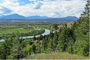
-The Old Coach Trail is a 9-kilometre walking or cycling route that runs between Radium Hot Springs and Dry Gulch.
-This is a historic route that was travelled by Model Ts in the 1920s — signage along the trail offers insight into this fascinating history. The trail winds along the benchlands above the Columbia River, offering spectacular views of the Columbia Wetlands below.
-The Old Coach Trail has two trailheads: north and south. The northernmost access is located in Radium at the southern end of Main Street West, accessible to hikers and bikers. A small parking area is available to vehicles, accessible right off Highway 93/95 just a moment’s drive south of the village.
-You can also drive 5 minutes south (towards Invermere) and park at the alternate trail head, and walk or cycle back to Radium. Either way, you won’t be disappointed!
-The restoration of this trail was made possible due to the efforts of local residents, contractors and agencies. We hope you enjoy your experience along the Old Coach Trail.
VI.History
-While oral history tells that the Ktunaxa bathed in Radium Hot Springs – perhaps to ease the pain from ailments or heal injuries incurred in battle. It wasn’t until 1841 when Sir George Simpson, the governor of the Hudson’s Bay Company, made the first recorded visit to the springs. He bathed in a gravel pool just big enough for one person. During the late 1800’s the first permanent settlers came to the area and the springs increased in popularity. In 1890 a man by the name of Rolond Stuart saw the economic potential of the springs and paid $1 an acre to receive a crown grant for 160 acres surrounding the pool. In 1911, a British Journal suggested that there might be radium in the water, which is a chemical element that is slightly radioactive, and in 1913 research done by McGill University proved this this to be true and the original concrete bathing pool and bathhouse was financed by multi-millionaire, St. John Harmsworth.
-While Mr. Stuart was able to capitalize on his investment for a number of years, he eventually went back to England at the start of the First World War. In 1920 negotiations between the federal and provincial governments commenced and the formation of the Kootenay Dominion Park was announced. In 1922 the boundaries of the Kootenay Dominion Park was amended, and the Hot Springs and other properties in the vicinity were expropriated by the government. Mr. Stuart was paid out $40,000 for his initial $160 investment and in 1925 Radium Hot Springs Lodge was opened to the public.
VII.Other information
-The Radium Hot Springs Centre is the newest venue in the Columbia Valley, providing a stunning venue for weddings, receptions, reunions, conferences, and community events.
-The Village of Radium Hot Springs opened its new Centre named the Radium Hot Springs Centre in August 2018.
-The Radium Hot Springs Centre is a multi-use facility, which includes a main hall, stage, kitchen and multi-purpose room. The Radium Hot Springs Centre is also home to the Radium Public Library.
-With gorgeous views of the surrounding mountains and natural scenery, the centre provides a stunning venue for weddings, receptions, reunions, conferences, community gatherings and many more events.
-For more information on the Radium Hot Springs Centre, including rental fees, facility photos and availability, please visit www.radiumhotsprings.ca.
-Website: https://www.radiumhotsprings.com/listing/radium-hot-springs-centre/
VIII.Contact information
-Government
•Governing body: Radium Town Council
•Mayor: Clara Reinhardt
-Village of Radium Hot Springs
•P.O. Box 340 Radium Hot Springs, BC V0A 1M0, Canada
•The Municipal office is open:
•Open Monday to Friday 8:30 am to 4:30 pm
•Closed Fridays 12:00 - 1:00 pm
•Closed for Statutory Holidays All Day
-Website: https://www.radiumhotsprings.com/contact-us/
