Port Renfrew, British Columbia 作者: 来源: 发布时间:2021-12-08
I.Population and Area
-Area
•Land: 8.69 km2 (3.36 sq mi)
-Population (2016)
•Total: 144
•Density: 16.6/km2 (43/sq mi)
II.Natural Geography (environment and resources)
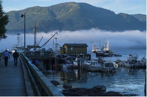
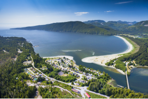
-Port Renfrew is a community on the west coast of Vancouver Island, British Columbia, Canada, located about a 2-hour drive west of Victoria, British Columbia. Port Renfrew is the western terminus of the Juan de Fuca Marine Trail.
-The climate is classic oceanic (Köppen: Cfb), because it is close to the Strait of Juan de Fuca towards the interior, the Mediterranean trend of rainfall patterns begins to be evidenced with high annual rainfall (proximity to the Csb), in terms of temperature is similar the Channel Islands. Summers are warm and almost fresh and winters are mild, one of the mildest in all of Canada.
-The coastline of British Columbia stretches approximately 27,000 km, including countless islands, bays, inlets and arms. It would take a lifetime to explore. Port Renfrew is the last step into this remote area.
-This is our “Jewel of the West Coast” & our “Tall Tree Capital of Canada”. A little fishing village once called “our little logging hamlet” by our un-official historian Jack Chester. We are surrounded by ancient rain forest, on the Pacific Rim of Vancouver Island, British Columbia, Canada. Our wilderness brings visitors from around the world to look with awe at Canada’s tallest and largest Douglas Firs, Cedars, and Spruce Trees. The area offers unlimited hiking and recreational activities for all ages.
III.ECONOMY
-Total - Income statistics in 2015 for the population aged 15 years and over in private households - 25% sample data: 100

-Website: https://www12.statcan.gc.ca/census-recensement/2016/dp-pd/prof/details/page.cfm?Lang=E&Geo1=DPL&Code1=590341&Geo2=PR&Code2=47&Data=Count&SearchText=Port%20Renfrew&SearchType=Begins&SearchPR=01&B1=All
IV.Industrial Characteristics
-In recent years, Port Renfrew has seen an increase in tourism. The Ancient Forest Alliance (AFA) has worked hard to locate and preserve some of North America's largest trees located around Port Renfrew. This preservation is paying off as people from all over the globe are now witnessing Avatar Grove and Canada's "gnarliest tree." The Red Creek fir, the world's largest Douglas fir, and San Juan Spruce, Canada's largest Sitka spruce, are also located in the area. Port Renfrew is filled with options that encompass all outdoor enthusiasts' needs. Local natural attractions include the West Coast Trail, Juan de Fuca Trail and Botanical Beach. Since 2010 the Tall Tree music festival has been held in Port Renfrew on the last weekend in June. Port Renfrew is considered one of the best locations for salmon and halibut fishing in North America. There is also excellent sea and freshwater (San Juan and Jordan River) kayaking and birding. The locals of Port Renfrew have been enjoying those trails and forests for decades.
V.Attractions
1.Botanical Beach Provincial Park
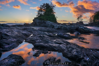
-The abundance of life was what drew Dr. Josephine Tildon to choose Botanical Beach as the location for the University of Minnesota's marine station in 1900. For seven years students and researchers came from all over the world to study here. To get to the station, a steamship would come from Victoria to Port Renfrew. From there it was on foot on a very muddy and narrow trail to the station. A better road in to the station was promised,however it did not materialize and the difficult access was considered a reason for the station's closure in 1907. There are few remains of the station left today. Universities still use Botanical Beach for field trips,and research,under park use permits. The area became a Class A provincial park in 1989.
-Botanical Beach has extensive upland habitat, but is best known for its abundance of intertidal life. A visitor can find hundreds of species of plants and animals. The organisms that live here must be able to handle a wide range of conditions. When the tide is out there are large changes in temperature, predators, food sources and salinity.
-Each creature has adapted to contend with these variable conditions. Organisms that can not cope with drying will survive in the tide pools or in shaded crevices. There you will find congregations of seastars, chitons and anemones, the seastars often piled together to conserve moisture loss. Barnacles, snails, mussels are able to survive by closing up tightly with a small amount of water inside their shells.
-There are some plants and animals that are specialists to the high impact waves found at Botanical Beach. The Gooseneck Barnacle(an animal),and the Sea Palm (a brown algae) are two of these. These organisms survive in the surf zone by being attached to the rock with flexible stocks that bend with the force of the waves. They are just two of the thousands of species of marine invertebrates and algae that can be found here at low tide. Purple Sea Urchins have established a particular niche in the soft sandstone. Their sharp,hard spines help to wear away indentations in which they live.
-Website: https://www.portrenfrew.com/botbeach.htm
2.Avatar Grove
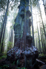
-Avatar Grove and Canada's gnarliest tree is an amazing thing to see and finding it is half the fun. The cute little town of Port Renfrew, know for it's logging, amazing fishing and home of one of the trailheads to the world renowned West Coast Trail, is now reworking it's image to include this fantastic wonder. Dubbed Canada's gnarliest tree this mammoth cedar will surely leap from the unknown to the feature of millions of tourist photos in the coming days and years.
-Avatar Grove is a 50 hectare area of old growth forest that has shot to prominence in this part of the world in recent years. It has been embraced as something to be saved, admired and loved, not cut into lumber. The Victoria based Ancient Forest Alliance is at the forefront of rescuing and protecting Avatar Forest. They discovered, named and drove it into the world's eyes. Avatar Grove is slowly growing into a hiking destination. Wooden stars and a boardwalk have been constructed and new additions are added frequently. There is even a viewing platform for the gnarly tree at an ideal location to take in the view. Though Avatar Grove and Canada's gnarliest tree is a couple hours drive from Victoria, the drive is very scenic. The various sections/trailheads of the Juan de Fuca Trail are all easy stops on the way to Avatar Grove. East Sooke Park, Witty's Lagoon, Fort Rodd Hill and many more sights are also located along the way.
-Contact information: info@HikeInVictoria.com
3.Sombrio Beach
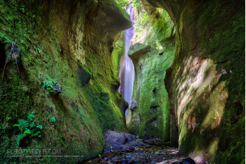
-Sombrio Beach is a beach on the west coast of Vancouver Island, British Columbia, Canada, southeast of the town of Port Renfrew. It is partially protected by Juan de Fuca Provincial Park and is crossed by the Juan de Fuca Marine Trail.
-TEL:778-425-1884
-Website: http://handsomedans.ca/contact-us/
4.Carmanah Walbran Provincial Park
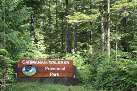
-Carmanah Walbran Provincial Park, originally Carmanah Pacific Provincial Park, is a remote wilderness park located inside traditional Ditidaht First Nation (also spelled diiɁdiitidq) ancestral territory. The park covers a land area of 16,450 ha immediately adjacent to Pacific Rim National Park Reserve's West Coast Trail on the southwestern, coastal terrain of Vancouver Island. The provincial park comprises the entire drainage of Carmanah Creek (northwest of the mouth of the creek hosted the kwaabaaduw7aa7tx village, a "local group" whose alliance makes up one branch of the Ditidaht Nation), and a good portion of the lower Walbran River drainage, both of which independently empty into the Pacific Ocean. The park is named after the Anglicized diitiid?aatx word kwaabaaduw7aa7tx, or Carmanah, meaning "thus far upstream" and John Thomas Walbran, a colonial explorer and ship's captain. Access to the park is by gravel logging road from Port Alberni, Lake Cowichan, or Port Renfrew.
-The Carmanah Walbran protects extensive tracts of luxuriant Pacific temperate rainforest, and is famous for its ancient old growth, which includes giant western redcedar, coast Douglas-fir, western hemlock, and towering groves of Sitka spruce that grow along the productive riverside flats. Some of the western redcedar in the area are well over 1,000 years old, and Canada's tallest tree, a Sitka spruce named the Carmanah Giant, measured at 95.836 m (314 ft), estimated to be around 400 years old, lives along the lower reaches of Carmanah Creek. However, trails to the Carmanah Giant and many other portions of the park are currently inaccessible due to the neglect and disrepair of the park's boardwalk trail system—trail access via the boardwalk is essential in preserving the area's delicate ecosystem. Although BC Parks received a funding increase in 2012 for the first time in over ten years, BC's provincial government has repeatedly cut funding to the BC Parks' budget, the result of which is BC Parks' inability to staff a sufficient number of Park Rangers to maintain the network of trails and keep the park safe from cedar poachers and illegal logging.
-Hiking trails were initially developed in the area by Randy Stoltmann and members of the Western Canada Wilderness Committee (what the Wilderness Committee was referred to at the time) in the late 1980s. The trails were built before the Carmanah Valley was protected in an effort to draw attention to the spectacular old-growth forest and the precarity of its existence in the face of Vancouver-based logging company, MacMillan Bloedel (now subsumed by Washington-based logging company Weyerhauser).
-Contact the Discover Camping Call Centre
-1-800-689-9025 (toll free from CAN/US)
-1-519-826-6850 (international)
-7am – 7pm Pacific Time
-$5 surcharge per transaction
-Website: http://bcparks.ca/info/feedback/
VI.History
-Port Renfrew is the home of the Pacheedaht First Nation, meaning "People of the Sea Foam", who have traditional village sites in and around the main town centre. The southern trailhead of the West Coast Trail, a world-famous hiking trail built in 1907 along the west coast of Vancouver Island to save shipwrecked sailors, is located on the Gordan River adjacent to Port Renfrew. The town is situated on the coast of the pacific ocean surrounded by large mountains covered with trees. This cove-like town is a peaceful getaway for all those interested in nature, hikes, fishing and many more extravagant activities. Like Sooke, B.C, Port Renfrew is a sport fishing paradise. Being located on the Pacific Ocean, it is excellent for catching Salmon and Halibut fishing and is one of the World-Class Sports fishing Destinations. The rich waters open up many fishing industries, and with their beautiful mountain top views, it brings in plenty of tourists and expands the economy of Port Renfrew. During the days of sail, 1830–1925, 137 major shipping tragedies occurred in the immediate vicinity of the entrance to the Strait of Juan de Fuca. International recognition was given to this stretch of water off Port Renfrew. It became known as the Graveyard of the Pacific. Originally named Port San Juan, the settlers changed the name to honor Lord Renfrew who planned to settle crofters there. The name was changed due to mail being sent to the San Juan Islands instead of Port San Juan. Port Renfrew's bay is still called Port San Juan. Like many coastal Vancouver Island communities, Port Renfrew has a rich history in forestry and fishing.
-The San Juan Valley has been home to the Pacheedhat First Nation for centuries, long before Port Renfrew started its history as a logging town. The inlet where Port Renfrew lies was named Port of San Juan in 1790 by Spanish-Peruvian explorer Manuel Quimper. The first European settlers began carving out their homesteads in 1859 shortly after the completion of Fort Victoria. In the 1880s, to spur growth, the government offered up to 350 acres of free land in the San Juan Valley to homesteaders. Emily and Alfred Deakin, with their daughter Violet, were one of the original European families to settle in the region. They developed 40 acres of land around the Deakin Trail in 1889 with intentions to farm. In the beginning the town was named Port San Juan, but mail confusion with the San Juan Islands spurred the Renfrew name change in 1895. Some claim that the settlers changed the name to honor Baron of Renfrew Prince Albert Edward who planned to encourage and develop crofting in the region.
-During this isolated period supplies were brought exclusively by boat. This was especially dangerous in winter months and many ships and lives were lost. Following the loss of 133 lives in 1906 aboard the Valencia the government moved to enhance an established First Nations trail from Port Renfrew to Bamfield (what is now The West Coast Trail) to provide communication and support when shipwrecks occurred. This safety trail also followed the Cape Beale telegraph line that was erected between 1889-1890.
-In 1912 Canadian Pacific Railway (1912-1957) began operations which connected Port Renfrew and Shawnigan Lake creating the first safe, constant flow of supplies to the region. By 1916 the community of 50 people had a hotel, school, post office and telegraph office. In 1923 the first large-scale steam logging operation began when T. Cathels and C. Sorenson moved to Port Renfrew and built the first logging camp. Their endeavor was financially backed by Victoria capitalists Todd and E.P. Butchart (Butchart Gardens). In the 1930s the Malahat Logging Company moved into the San Juan Valley and extended the railway with the completion of the Bear Creek Trestle in 1939. Standing 242 feet high the trestle was the highest in the world at that time. Malahat Logging Co. also created three camps for workers: Bear Creek, Harris Creek and Beach Camp, where the Port Renfrew Beach House is located today. The railway was the artery of the region. The lines were consistently busy moving logs, workers and supplies for the communities until the completion of the Bear Creek truck trestle in 1957.
-This new trestle allowed vehicles to travel to Port Renfrew from Shawnigan Lake on the Renfrew Road (todays Red Creek Fir Main Line). The promise of the road was finally realized almost 75 years after European settlers began to call this region home.
-Between 1957 and 1963 the Harris and Bear Creek camps were closed and their bunk houses moved to Beach Camp. At this time all logging activities were moved from Beach Camp to the present day Port Renfrew Marina on the Gordon River.
-Upon the completion of this newly-designed camp, the town of Port Renfrew began to take its current shape and contained nearly 100 homes. Electricity came to Port Renfrew in 1958 along with the development of a new road from Victoria. For some perspective on the development of electricity in cities consider that Victoria had its first street car in 1890.
-Port Renfrew continued to grow as road improvements made the trip easier and safer. Port Renfrew relied heavily on industrial logging as its principle economic engine until 1990 when Fletcher Challenge moved their operations to Cowichan Lake. The Capital Regional District (CRD) began accepting ownership of the services and utilities in the 1990s when Port Renfrew joined the district and began its economic transition to one that is driven primarily by tourism and fishing.
-Website: https://www.portrenfrewbeachhouse.com/history-of-port-renfrew/
VII.Other information
-Infrastructure
•Port Renfrew is a seaside community centered around the local wharf, and provides visitors and residents with a relaxed, personable atmosphere as only a small village can create.
•Several major changes have put Port Renfrew on the map in recent years. The most significant development is the completion of the $25+ million dollar, Pacific Marine Highway Circle Route, connecting Port Renfrew to eastern and northern Vancouver Island with a new paved highway. The completion of the circle route in 2009 has brought increased traffic and exposure to the region from areas such as Duncan and Nanaimo where transit time is now 1.5 to 2 hours instead of 3 to 3.5 hours. The circle Route has also enhanced Port Renfrew’s accessibility to Alberta traffic flying into Comox airport.
•During 2012, the provincial government injected nearly 20 million dollars into road highway improvements with the building of 2 new bridges and upgrading of road surface.
•Website: http://liveportrenfrew.com/about-port-renfrew/
VIII.Contact information
-President: Anne Tremblay
-VP: Tomi Smith
-Secretary: Moira Mulligan
-Treasurer: Dan Quigley
-Directors:
•Lynne Conlin
•Jon Cash
•Amanda Williams
•Kristine Pearson
-Website: https://www.portrenfrewcommunity.com/
-Website: portrenfrew.com
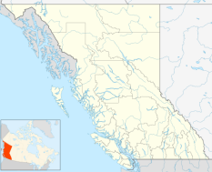
-Location: Port Renfrew, British Columbia, Canada
-Email: webmaster@portrenfrew.com
