Inuvik, Northwest Territories 作者: 来源: 发布时间:2021-12-07
I.Population and Area
-Area
Land: 62.48 km2 (24.12 sq mi)
-Population (2016)
Total: 3,243
Density: 51.9/km2 (134/sq mi)
II.Natural Geography (environment and resources)
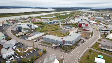
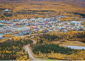
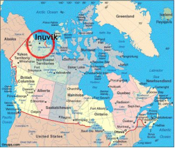
-Inuvik /ɪˈnuːvɪk/ (place of man) is a town in the Northwest Territories of Canada within Inuit Nunangat and is the administrative centre for the Inuvik Region.
-The population as of the 2016 Census was 3,243, a decrease of 6.4% from the 2011 Census and a decrease of 7.0% from the 2006 Census. The two previous census counts show wide fluctuations due to economic conditions: 2,894 in 2001 and 3,296 in 1996.
-As of the 2016 Census there were 2,080 people who identified as Indigenous. 63.2% were Inuvialuit (Inuit, predominantly Uummarmiut), 31.0% First Nations and 5.3%; Métis. The non-native population of Inuvik was 36.7%. The main language spoken in Inuvik is English, though schools teach and a handful of local people still speak Inuinnaqtun (Inuvialuktun), and Gwich’in. Local CBC Radio, CHAK (AM), broadcasts an hour of programming a day in each of these languages. Local Gwich'in are enrolled in the Inuvik Native Band.
-There are also about 100 Muslims, most of whom came there for economic opportunities. A small mosque (dubbed "Little mosque on the tundra" in reference to the CBC show Little Mosque on the Prairie) was established in 2010. In 2017 the Government of the Northwest Territories reported that the population was 3,192 with an average yearly growth rate of -1.2% from 2007.
-Inuvik is located on the East Channel of the Mackenzie Delta, approximately 100 km (60 mi) from the Arctic Ocean and approximately 200 km (120 mi) north of the Arctic Circle. The tree line lies north of Inuvik and it is surrounded by boreal forest.
-Due to its northern location, Inuvik experiences an average of 56 days of continuous sunlight every summer and 30 days of polar night every winter.
-Transportation
-Most roads in Inuvik are paved. There are both concrete and metal-grill sidewalks alongside the roads.
-The Dempster Highway provides access to Inuvik for the majority of the year. However, the highway relies on ferries and ice bridges to get across the rivers. It is thus closed during the time of freeze-up (roughly late-October to mid-December), for ice to form and allow ice bridges, and thaw (roughly mid-May to mid-June) to allow the ferry to run. At these times, there is air access only.
-The main airport is Inuvik (Mike Zubko) Airport. There is also a general aviation airport, Inuvik/Shell Lake Water Aerodrome.
-When the Mackenzie River is ice-free, Northern Transportation Company Limited provides a commercial barge service from Hay River, on Great Slave Lake to the regional terminal in Inuvik. The annual sealift moves supplies as far east as Taloyoak, Nunavut and west to Utqiagvik, Alaska.
-A distinct feature of Inuvik is the use of "utilidors" – above-ground utility conduits carrying water and sewage – which are covered by corrugated steel. They run throughout town connecting most buildings, and as a result there are many small bridges and underpasses. The utilidors are necessary because of the permafrost underlying the town.
-Another feature is an Inuksuk placed outside the Mackenzie Hotel, which was rebuilt in 2006.
-Climate
-Inuvik has a subarctic climate (Köppen Dfc). Summers are typically wetter and cool, with temperatures varying wildly throughout the months due to its peculiar location near the cold Arctic Ocean. The average hottest month of the year, July, has a mean high of 19.5 °C (67.1 °F) and mean low of 8.6 °C (47.5 °F). Unlike many other North American continental climates, Inuvik warms up very quickly during the months of May and June due to the rapidly increasing day length, and that remaining snow cools down until May. June is a warmer month than August. Seasonal transitions are extremely short, with mean daily temperatures rising or falling as fast as 0.5 °C (0.9 °F) per day. Winters are long and extremely frigid; the coldest month of the year, January, having a mean high of −22.8 °C (−9.0 °F) and a mean low of −31.0 °C (−23.8 °F). Freezing temperatures can occur any month of the year. Inuvik has a great variation of temperatures during the year, usually peaking below −40 °C (−40 °F) in the winter and above 30 °C (86 °F) in the summer. The highest temperature ever recorded in Inuvik was 32.8 °C (91 °F) on 17 June 1999 and 20 July 2001. The coldest temperature ever recorded was −56.7 °C (−70 °F) on 4 February 1968.
-Snow that falls from October onward usually stays until the spring thaw in mid-May. By March, the median snow depth has reached its greatest, about 56.2 cm (22.1 in).
III.ECONOMY
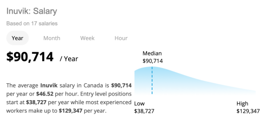
-The average Inuvik salary in Canada is $90,714 per year or $46.52 per hour. Entry level positions start at $38,727 per year while most experienced workers make up to $129,347 per year.
-Website: https://neuvoo.ca/salary/?job=Inuvik
IV.Industrial Characteristics
-Agriculture in the Northwest Territories is a small but emerging sector of the economy. Motivated by high food costs, positive contributions to lifestyles, local product diversity, and increased awareness of nutritional values, participation in local food production is increasing in most, if not all, communities in the NWT. Ranging from small community gardens to commercial greenhouses, regulated egg production and harvesting of “wild” edibles, the local food production sector has grown dramatically over the past decade. The agricultural sector generates approximately $8-10 million in income per annum in the NWT. The industry can be divided into three categories:
Small scale - community and market gardens;
Commercial agriculture and large scale production; and,
Commercial harvest of game.
-Website: https://www.investnwt.com/sites/default/files/industry_profiles_0.pdf
V.Attractions
1.Our Lady of Victory Church
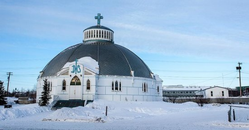
-Our Lady of Victory Church, often called the Igloo Church, is located on Mackenzie Road in downtown Inuvik, Northwest Territories, Canada. It serves a Catholic parish of the Diocese of Mackenzie-Fort Smith. It was established in the mid-1950s, around the time Inuvik was being built; the church was opened and consecrated in 1960 after two years of construction.
-Brother Maurice Larocque, a Catholic missionary to the Arctic who had previously been a carpenter, designed the church despite a lack of any formal architectural training, sketching it on two sheets of plywood that are prominently displayed in the building's upper storeys. The round shape, which is painted to mimic an igloo, was chosen to mitigate possible structural damage that might be caused by frost heave. Its unique structural system, "a dome within a dome", further protects the church with a foundation consisting of a bowl-shaped concrete slab on a gravel bed atop the permafrost and, in the building itself, an intricate system of wooden arches to support the load.
-It is the only major building in Inuvik that does not rest on pilings. Wood for the church was floated down the Mackenzie River from Fort Smith, nearly 2,000 kilometres (1,200 mi) away. Construction was completed without a building permit as the federal government officials in Ottawa who would have issued one could not understand Larocque's blueprints and sent them back to Inuvik.
-Today the church is the town's best-known landmark and its most-photographed building. Travel writer Robin Esrock describes it as "a church that doesn't look like any other church on Earth." The interior is decorated with paintings by Inuit artist Mona Thrasher. In the summer months the parish gives tours.
-Address: 178 MacKenzie Rd, Inuvik, NT X0E 0T0
-Phone: (867) 777-2236
-Website: https://olvinuvik.com/
2.Happy Valley Territorial Park
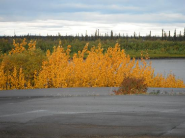
-Located in the heart of Inuvik, this park offers 19 powered and 8 non-powered sites, and convenient access to the town’s attractions. The park is situated on a bluff overlooking the east branch of the Mackenzie River, and offers a view of the Richardson Mountains. Don't forget to book ahead, the park fills up during the busy summer months!
-Address: Marine Bypass Road, Inuvik, Northwest Territories Canada
-Email: https://www.nwtparks.ca/campgrounds/happy-valley-territorial-park
3.Western Arctic Regional Visitor Center
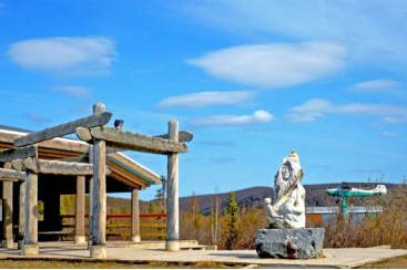
-Western Arctic Regional Visitor Center is located in Inuvik. Arrange your visit to Western Arctic Regional Visitor Center and discover more family-friendly attractions in Inuvik using our Inuvik route builder app.
-Contact
276 Mackenzie Road, Inuvik, Northwest Territories Canada
-TEL: +1 867-777-4727
-Email: https://www.inspirock.com/canada/inuvik/western-arctic-regional-visitor-center-a4155071579
VI.History
-Inuvik was conceived in 1953 as a replacement administrative centre for the hamlet of Aklavik on the west of the Mackenzie Delta, as the latter was prone to flooding and had no room for expansion. Initially called "New Aklavik", it was renamed Inuvik in 1958. The school was built in 1959 and the hospital, government offices and staff residences in 1960, when people, including Inuvialuit, Gwich’in (Dene) and Métis, began to live in the community.
-Naval Radio Station (NRS) Inuvik, later CFS Inuvik, callsign CFV, was commissioned on 10 September 1963 after operations had been successfully transferred from NRS Aklavik. Station CFV was part of the SUPRAD (Supplementary Radio) network of intercept and direction finding stations.
-CFS Inuvik closed on 1 April 1986 and the site was transferred to the Department of Transport for use as a telecommunications station. Nothing remains of CFS Inuvik today. Even now, many people of all backgrounds still lament its closing. The Navy Operations base at the end of Navy Road was completely dismantled and removed.
-Inuvik achieved village status in 1967 and became a full town in 1979 with an elected mayor and council. In 1979, with the completion of the Dempster Highway, Inuvik became connected to Canada's highway system, and simultaneously the most northerly town to which one could drive in the summer months — although an ice road through the Mackenzie River delta connects the town to Tuktoyaktuk, on the coast of the Arctic Ocean, and Aklavik, in the winter, and an all-weather road connecting Inuvik and Tuktoyaktuk opened in November 2017, replacing that portion of the ice road.
-Between 1971 and 1990, the town's economy was supported by the local Canadian Forces Station, CFS Inuvik, (originally a Naval Radio Station, later a communications research/signals intercept facilit) and by petrochemical companies exploring the Mackenzie Valley and the Beaufort Sea for petroleum. This all collapsed in 1990 for a variety of reasons, including disappearing government military subsidies, local resistance to petroleum exploration, and low international oil prices. Since then the economy has been based on some minor tourism and subsidy provided by the Indigenous and Northern Affairs Canada (INAC), Health Canada (for the regional hospital) and the Royal Canadian Mounted Police.
VII.Other information
-Facilities
-Inuvik Regional Hospital
-A new hospital opened in early 2003, providing service to an area extending from Sachs Harbour on Banks Island, to Ulukhaktok on Victoria Island, and from Paulatuk into the Sahtu Region including Norman Wells, Tulita, Deline, Fort Good Hope, and Colville Lake.
-The Midnight Sun Complex, a stage-built multi-use facility, was completed in 2006. Featuring the Roy 'Sugloo' Ipana Memorial Arena, with an NHL-sized ice surface; the Inuvik Curling Club with 3 sheets and a well-situated licensed lounge/viewing area; the Inuvik Pool, an award-winning Class B recreational pool with lane swimming, waterpark features including a two-story waterslide, hot tub, sauna and steam room; two squash courts; a multi-use community hall with stage; on-site business centre/production office; full building wireless; video-conferencing facility; on-site catering/kitchen; and meeting rooms for groups of 5 to 500. At full-building use, the Complex can host conferences, conventions and trade shows with up to 1200 delegates/exhibitors.
-The community has a state-of-the-art school called East 3. The construction budget for the school exceeded $110 million, and it features modern technologies such as 'smartboards' and videoconferencing facilities as well as a large gym.
VIII.Contact information
-Government
MP: Michael McLeod
Mayor: Natasha Kulikowski
-Town of Inuvik
Address: Box 1160, #2 Firth Street, Inuvik, NT X0E 0T0
Tel: 867-777-8600
Fax: 867-777-8601
Email link: https://www.inuvik.ca/en/Modules/email/emailattachment.aspx?id=90670&ref=https://www.inuvik.ca/en/index.asp
-Website: https://www.inuvik.ca/en/index.asp
