Prince Rupert, British Columbia 作者: 来源: 发布时间:2021-12-06
I.Population and Area
-Area
Land: 54.93 km2 (21.21 sq mi)
-Population (2016)
Total: 12,220
Density:227.7/km2 (590/sq mi)
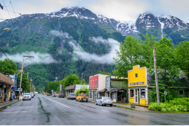
II.Natural Geography (environment and resources)
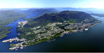
-Prince Rupert is a port city in the province of British Columbia, Canada. Its location is on Kaien Island near the Alaskan panhandle. This port city is the land, air, and water transportation hub of British Columbia's North Coast, and has a population of 12,220 people as of 2016.
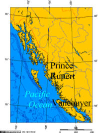
-Prince Rupert is on Kaien Island (approximately 770 km (480 mi) northwest of Vancouver), just north of the mouth of Skeena River, and linked by a short bridge to the mainland. The city is along the island's northwestern shore, fronting on Prince Rupert Harbour.
-At the secondary western terminus of Trans-Canada Highway 16 (the Yellowhead Highway), Prince Rupert is approximately 16 km west of Port Edward, 144 km west of Terrace, and 715 km west of Prince George.
-Transportation
-Seaport
Prince Rupert Harbour
Main article: Prince Rupert Port Authority
A belief at the beginning of the 1900s that trade expansion was shifting from Atlantic to Pacific destinations, and the benefit of being closer to Asia than existing west coast ports, proved wishful. Reduced transit times to eastern North America and Europe did not outweigh the fact that rail transport has always been far more expensive than by sea. The opening of the Panama Canal in 1914 exacerbated the problem.
During 1906–08, the federal government undertook a hydrographic survey of the Prince Rupert harbour and approaches, finding it free of rocks or obstructions, and sufficient depth for good anchorage. Furthermore, it offered an easy entrance, fine shelter, and ample space. By 1909, a 1,500-foot wharf had been constructed.
The port possesses the deepest ice-free natural harbour in North America, and the 3rd deepest natural harbour in the world. Situated at 54° North, the harbour is the northwestern most port in North America linked to the continent's railway network. The port is the first inbound and last outbound port of call for some cargo ships travelling between eastern Asia and western North America since it is the closest North American port to key Asian destinations. The CN Aquatrain barge carries rail cargo between Prince Rupert and Whittier, Alaska.
Passenger ferries operating from Prince Rupert include BC Ferries' service to the Haida Gwaii and to Port Hardy on Vancouver Island, and Alaska Marine Highway ferries to Ketchikan, Juneau and Sitka and many other ports along Alaska's Inside Passage. The Prince Rupert Ferry Terminal is co-located with the Prince Rupert railway station, from which Via Rail offers a thrice-weekly Jasper – Prince Rupert train, connecting to Prince George and Jasper, and through a connection with The Canadian, to the rest of the continental passenger rail network.
The Prince Rupert Port Authority is responsible for the port's operation.
Much of the harbour is formed by the shelter provided by Digby Island, which lies windward of the city and contains the Prince Rupert Airport. The city is on Kaien Island and the harbour also includes Tuck Inlet, Morse Basin, Wainwright Basin, and Porpoise Harbour, as well as part of the waters of Chatham Sound which takes in Ridley Island.
-Port facilities
Lucy Island Lighthouse, built 1907
Main article: Prince Rupert Port Authority
Prince Rupert is ideally located for a port, having the deepest natural harbour depths on the continent. The city's port capacity is comparable with the Port of Vancouver's. Unlike most west coast ports, there is little traffic congestion at Prince Rupert. Finally, the extremely mountainous nature and narrow channels of the surrounding area leaves Prince Rupert as the only suitable port location in the inland passage region.
The Prince Rupert Port Authority (PRPA) is a federally appointed agency which administers and operates various port properties on the harbour. Previously run by the National Harbours Board and subsequently the Prince Rupert Port Corporation, the PRPA is now a locally run organization.
PRPA port facilities include:
Atlin Terminal
Northlands Terminal
Lightening Dock
Ocean Dock
Westview Dock
Fairview Terminal
Prince Rupert Grain
Ridley Terminals
Sulphur Corporation
All PRPA facilities are serviced by CN Rail.
The Canadian Coast Guard maintains CCG Base Seal Cove on Prince Rupert Harbour where vessels are homeported for search and rescue and maintenance of aids to navigation throughout the north coast. CCG also bases helicopters at Prince Rupert for servicing remote locations with aids to navigation, as well as operating a Marine Communications Centre, covering a large Vessel Traffic Services zone from Port Hardy at the northern tip of Vancouver Island to the International Boundary north of Prince Rupert.
Both BC Ferries and the Alaska Marine Highway operate ferries which call at Prince Rupert, with destinations in the Alaska Panhandle, the Haida Gwaii, and isolated communities along the central coast to the south.
-Airport
-Prince Rupert Airport (YPR/CYPR) is on Digby Island. Its position is 54°17′10″N 130°26′41″W, and its elevation is 35 m (116 ft) above sea level. The airport consists of one runway, one passenger terminal, and two aircraft stands. Access to the airport is typically achieved by a bus connection that departs from downtown Prince Rupert (Highliner Hotel) and travels to Digby Island by ferry. The airport is served by Air Canada from Vancouver International Airport (YVR).
Prince Rupert is also served by the Prince Rupert/Seal Cove Water Aerodrome, a seaplane facility with regularly scheduled, as well as chartered, flights to nearby villages and remote locations.
-Railway
-CN Rail has a mainline that runs to Prince Rupert from Valemount, British Columbia. At Valemount, the Prince Rupert mainline joins the CN mainline from Vancouver. Freight traffic on the Prince Rupert mainline consists primarily of grain, coal, wood products, chemicals, and as of 2007, containers. As the renovations at the Port of Prince Rupert continue, traffic on CN will steadily rise in future years.
In addition, a three times weekly Jasper – Prince Rupert train operated by Via Rail connects Prince Rupert with Prince George and Jasper. Running during daylight hours to allow passengers to be able to see the scenery along the entire route; the service takes two days and requires an overnight hotel stay in Prince George. The route ends in Jasper and connects passengers with Via's The Canadian, which runs between Toronto and Vancouver.
III.ECONOMY
-Average Hourly Rate in Prince Rupert, British Columbia: C$21.96

-Website: https://www.payscale.com/research/CA/Location=Prince-Rupert-British-Columbia/Salary
IV.Industrial Characteristics
-Prince Rupert relies on the fishing industry, port, and tourism.
-Settlement and Development
Kaien Island was once a meeting place of the Tsimshian and Haida peoples. Prince Rupert (named for the first Hudson's Bay Company governor) was envisioned in the early 1900s as the western end of the Grand Trunk Pacific Railway (GTPR). Some hoped the town would rival Vancouver as Canada's outlet along the Pacific coast, but the hoped-for boom never materialized. The fishing industry became important to the city's economy after the First World War. During the Second World War, the port became a shipbuilding centre and was used by the American army as a transportation base for soldiers and materials to Alaska, the Pacific Islands and the East Asia. After the war the economy received a boost with the development of a pulp mill on Watson Island.
The port of Prince Rupert (1912) was designated a national port in 1972. Fairview, a general cargo and forest products terminal, was completed in 1977. Twenty years later, in 1997, the Prince Rupert Port Authority was established as the port’s governing body. In the early 1980s, new interest in the coalfields of northeastern British Columbia affected the city. Ridley Terminals, a coal shipment facility, opened on nearby Ridley Island in 1984. In 2019, the Ridley Island Export Terminal began to ship propane to Asia.
-Economy
The Pacific Rim countries are the destination for the majority of the exports through Prince Rupert. Although the city suffered in the 1990s with the closure of the coal mines of northeastern British Columbia and of its pulp mill in 2001, trade with China and other Asian countries has since rebounded. Prince Rupert is the most important fish-landing port on the northwest coast and the terminus of the BC and Alaska ferry systems. Tourism is growing rapidly with the expansion of cruise ship traffic, and locally in terms of sportfishing.
-Website: https://www.thecanadianencyclopedia.ca/en/article/prince-rupert
V.Attractions
1.The North Pacific Cannery
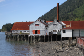
-The North Pacific Cannery located near Port Edward, British Columbia, is one of the longest standing canneries in the Port Edward area. NPC was founded in 1889 by Angus Rutherford Johnston, John Alexander Carthew, and Alexander Gilmore McCandless. The plant stopped processing salmon in 1968, becoming a reduction plant until its closure in 1981 after 80 years of operations.
-The North Pacific Cannery was built at the mouth of the Skeena River on “Cannery Row”. The 183 acres of land was purchased for $32 by John Alex Carthew (Giesbreecht 2016, 29). In order for the North Coast Marine Museum Society to preserve NPC, it had to receive funds up to $4 million, which was succeeded by the canneries 100th anniversary in 1989 (Giesbreecht 2016, 36). NPC has 25 buildings that can be toured, including a visitor centre, canning loft, First Nations and Japanese bunk houses, European house, and the Mess House, which has been turned into a small café (Giesbreecht 2016, 36).
-Address: 1889 Skeena Dr, Port Edward, BC V0V 1G0
-Phone: (250) 628-3538
-Website: https://www.northpacificcannery.ca/
2.The Museum of Northern British Columbia
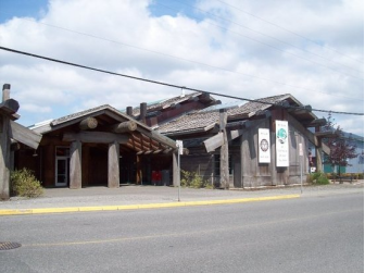
-The Museum of Northern British Columbia is a museum in Prince Rupert, British Columbia, Canada.
-The museum is housed in a large cedar wood longhouse where it collects and exhibits the culture and history of the indigenous peoples of the Pacific Northwest Coast. It was founded in 1924 and now houses thousands of artifacts, maps, photographs and other material. It also organises archaeological and historical tours such as a visit to the Tsimshian village of Metlakatla.
-Address:100 First Ave., Prince Rupert, British Columbia V8J 3S1 Canada
-Phone: (250) 624-3207
-Website: https://www.tripadvisor.ca/Attraction_Review-g154939-d185622-Reviews-Museum_of_Northern_British_Columbia-Prince_Rupert_British_Columbia.html
3.Sunken Gardens Park
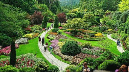
-Sunken Gardens Park and Trail in Prince Rupert, British Columbia, Canada is a small two level park with a short pebbled walkway leading through a tunnel into an open area surrounded by brick walls fronting floral gardens. The area is well manicured and maintained with sitting benches and picnic tables so to enjoy the scenery.
-Sunken Gardens Park sits on the first location designated for the community court houses. But in 1923, after more planning and more politics, the Provincial Court House in Prince Rupert was completed but not in the original location - the site was moved forward leaving a hole behind the building.
-The hole, the original site of the court house, is now the Sunken Gardens. The brick wall is the old foundation. At one time, during the world wars, munitions were stored in the tunnels which are now walkways in the park.
-Today, the tunnels and the foundation have been transformed into a community park. Located within walking distance of the Sunken Gardens are the Pacific Mariner’s Memorial Park, the carving shed, Cow Bay and the Prince Rupert Waterfront Park.
-Phone: +1 303-458-4788
-Website: https://www.ehcanadatravel.com/british-columbia/northern-bc/prince-rupert/parks-places/5254-sunken-gardens-park.html
VI.History
Coast Tsimshian occupation of the Prince Rupert Harbour area spans at least 5,000 years. About 1500 B.C. there was a significant population increase, associated with larger villages and house construction. The early 1830s saw a loss of Coast Tsimshian influence in the Prince Rupert Harbour area.
-Founding
-Prince Rupert replaced Port Simpson as the choice for the Grand Trunk Pacific Railway (GTP) western terminus. It also replaced Port Essington, 29 kilometres (18 mi) away on the southern bank of the Skeena River, as the business centre for the North Coast (see #Seaport).
-The GTP purchased the 14,000-acre First Nations reserve, and received a 10,000-acre grant from the BC government. Surveys and clearing, that commenced in 1906, preceded the laying out of the 2,000-acre town site. A $200,000 provincial grant financed plank sidewalks, roads, sewers and water mains. Kaien Island, which comprised damp muskeg overlaying a solid rock foothill, proved expensive both for developing the land for railway and town use.
-By 1909, the town possessed 4 grocery, 2 hardware, 2 men's clothing, a furniture, and several fruit and cigar stores, a wholesale drygoods outlet, a wholesale/retail butcher, 2 banks, the GTP hotel and annex, and numerous lodging houses and restaurants. The first lot sales that year created a bidding war.
-Prince Rupert was incorporated on March 10, 1910. Although he never visited Canada, it was named after Prince Rupert of the Rhine, the first Governor of the Hudson's Bay Company, as the result of a nation-wide competition held by the Grand Trunk Railway, the prize for which was $250.
-With the collapse of the real estate boom in 1912, and World War I, much of the company's land remained unsold. Charles Melville Hays, president of the GTP, whose business plan made little sense, was primarily responsible for the bankruptcy of the company, and the establishment of a town that would take decades to achieve even a small fraction of the promises touted. Mount Hays, the larger of two mountains on Kaien Island, is named in his honour, as is a local high school, Charles Hays Secondary School. The train station, a listed historic place, replaced the temporary building in 1922.
-20th and 21st centuries
-Local politicians used the promise of a highway connected to the mainland as an incentive, and the city grew over the next several decades. American troops finally completed the road between Prince Rupert and Terrace during World War II to help move thousands of allied troops to the Aleutian Islands and the Pacific. Several forts were built to protect the city at Barrett Point and Fredrick Point.
-After World War II, the fishing industry, particularly for salmon and halibut, and forestry became the city's major industries. Prince Rupert was considered the Halibut Capital of the World from the opening of the Canadian Fish & Cold Storage plant in 1912 until the early 1980s. A long-standing dispute over fishing rights in the Dixon Entrance to the Hecate Strait (pronounced as "hekk-et") between American and Canadian fisherman led to the formation of the 54-40 or Fight Society. The United States Coast Guard maintains a base in nearby Ketchikan, Alaska.
-In 1946, the Government of Canada, through an Order in Council, granted the Department of National Defence the power to administer and maintain facilities to collect data for communications research. The Royal Canadian Navy was allotted forty positions, seven of which were in Prince Rupert. In either 1948 or 1949, Prince Rupert ceased operations, and the positions were relocated to RCAF Whitehorse, Yukon. The 1949 Queen Charlotte earthquake, with a surface wave magnitude of 8.1 and a maximum Mercalli intensity of VIII (Severe), broke windows and swayed buildings on August 22.
-In Summer 1958, Prince Rupert endured a riot over racial discrimination. Ongoing discontent with heavy-handed police practices towards Aboriginals escalated to rioting during BC Centennial celebrations following the arrest of an Aboriginal couple. As many as 1,000 people (one tenth of the city's population at the time) began smashing windows and skirmishing with police. The Riot Act was read for only the second time since Confederation.
-Over the years, hundreds of students were said to have largely paid their way through school by working in the lucrative fishing industry. Construction of a pulp mill began in 1947 and it was operating by 1951. The construction of coal and grain shipping terminals followed. From the 1960s into the 1980s, the city constructed many improvements, including a civic centre, swimming pool, public library, golf course and performing arts centre (recently renamed "The Lester Centre of the Arts"). These developments marked the town's changes from a fishing and mill town into a small city.
-In the 1990s, both the fishing and forestry industries suffered a significant downturn. In July 1997, Canadian fishermen blockaded the Alaska Marine Highway ferry M/V Malaspina, keeping it in the port as a protest in the salmon fishing rights dispute between Alaska and British Columbia. The forest industry declined when a softwood lumber dispute arose between Canada and the USA. After the pulp mill closed, many people were unemployed, and much modern machinery was left unused. After reaching a peak of about 18,000 in the early 1990s, Prince Rupert's population began to decline, as people left in search of work.
-The years from 1996 to 2004 were difficult for Prince Rupert, with closure of the pulp mill, the burning down of a fish plant and a significant population decline. 2005 may be viewed as a critical turning point: the announcement of the construction of a container port in April 2005, combined with new ownership of the pulp mill, the opening in 2004 of a new cruise ship dock, the resurgence of coal and grain shipping, and the prospects of increased heavy industry and tourism may foretell a bright future for the area. The port is becoming an important trans-Pacific hub.
VII.Other information
-Infrastructure
The City of Prince Rupert currently maintains over 60 km of roads for our community, as well as four bridges that connect the different areas of the community. Each year, the City prioritizes areas for infrastructural renewal in our capital budget according to the needs of the community. To help us serve you better, please let us know if you have identified an area of concern.
-Prince Rupert Community Water System
Few issues are more important to a municipality than the quality of the drinking water it delivers. The Prince Rupert water system feds approximately 6 million cubic meters of potable water per year to local residents, businesses, and industry, utilizing over 50 kilometers of distribution line and close to 6000 individual service connections. The system is also capable of meeting local industrial needs, which at times can generate over twice the average daily consumption.
As a barrier of defense against the incidence of waterborne disease, the municipality maintains an enduring chlorine residual throughout the water distribution system. Chlorine is the most reliable and widely used drinking water disinfectant in North America. A “residual” is the trace amount of chlorine left in the drinking water after initial disinfection have taken place. As long as a trace of chlorine or residual can be detected, the line is still subject to active disinfection. To ensure water quality, various types of water quality samples are taken daily, weekly, or at other regular intervals.
- Website: http://www.princerupert.ca/services/infrastructure/drinking_water
VIII.Contact information
-Government
Governing body: Prince Rupert City Council
Mayor: Lee Brain
-Prince Rupert City Hall
424 3rd Ave West, Prince Rupert, BC, V8J 1L7
Tel: 250-627-0960
Fax: 250-627-0979
Email: cityhall@princerupert.ca
Office Hours: 9:30am – 4:30pm Mon to Fri
CLOSED weekends and Stat Holidays
-Administration Department
424 3rd Ave West, Prince Rupert, BC, V8J 1L7
Tel: 250-627-0934
Fax: 250-627-0999
Email: cityhall@princerupert.ca
Office Hours: 9:30am – 4:30pm Mon to Fri
CLOSED weekends and Stat Holidays
-Website: http://www.princerupert.ca/city_hall/contact
