Bowen Island, British Columbia 作者: 来源: 发布时间:2021-12-06
I.Population and Area
-Area
Land: 50.14 km2 (19.36 sq mi)
-Population (2016)
Total: 3,680
-Density: 73.4/km2 (190/sq mi)
II.Natural Geography (environment and resources)
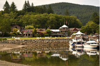
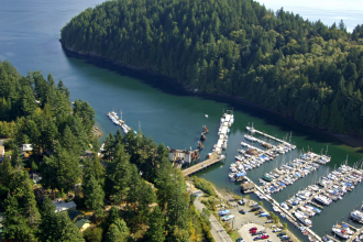
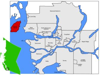
-Bowen Island (originally Nex̱wlélex̱m in Sḵwx̱wú7mesh Sníchim), British Columbia, is an island municipality that is part of Metro Vancouver. In addition, Bowen Island is within the jurisdiction of the Islands Trust. Located in Howe Sound, Bowen Island is approximately 6 kilometres (3.7 mi) wide by 12 kilometres (7.5 mi) long, with the island at its closest point about 3 kilometres (1.9 mi) west of the mainland. There is regular ferry service from Horseshoe Bay, as well as semi-regular water taxi services. The population of 3,680 is supplemented in the summer by roughly 1,500 visitors, as Bowen Island is a popular vacation home location for British Columbians. Approximately 500 workers and over 200 students commute to offices and schools on the mainland each day. The island has a land area of 49.94 km2 (19.28 sq mi).
-Transportation
-Marine
Queen of Capilano Ferry Approaching Snug Cove, Bowen Island, British Columbia
Bowen Island is served by three scheduled water-transportation operators:
BC Ferries, a de facto Provincial Crown corporation, serves the island with the Queen of Capilano car ferry, which travels between Horseshoe Bay in West Vancouver and Snug Cove on Bowen Island.
English Bay Launch runs a passenger-only water taxi weekday commuter service between Snug Cove and Vancouver's Coal Harbour, and on summer weekends runs a tourist service between Snug Cove and Vancouver's Granville Island.This taxi service was shut down in 2018 due to the dock they used by the Parks Board on the Vancouver side being deemed unsafe.
Cormorant Marine runs a passenger-only water taxi service providing late-night sailings between the government docks in Horseshoe Bay and in Snug Cove. In addition, weekday commuter sailings are made between Snug Cove and Horseshoe Bay, to connect with the Bowen Express Bus from downtown Vancouver.
-Land
Public roads are maintained by the Bowen Island Municipality. There are roadside walking trails in only a few places and the terrain is hilly and winding. Private vehicles are the primary form of transportation and hitchhiking is commonplace.
Bowen Island has a limited bus service on these TransLink routes, which are timed to meet some ferry sailings:
Route 280 Bluewater/Snug Cove
Route 281 Eagle Cliff/Snug Cove
Route 282 Mount Gardner/Snug Cove (Weekends and Holidays only)
III.ECONOMY
-In Bowen Island, BC, the median household income is $89,856 per year. The median household income in Bowen Island, BC is greater than the national household median income in 2015.
-Website: https://townfolio.co/bc/bowen-island/summary
IV.Industrial Characteristics
-Bowen Island is served by a number of small businesses including marinas, cafes, gift shops, grocery stores, a post office, pharmacy, restaurants, garden and flower shops, and a building supply yard. Bowen Island is served by First Credit Union, and by an Exchange Network ATM operated by North Shore Credit Union. Bowen Island's commercial sector is primarily located within Snug Cove and Artisan Square.
V.Attractions
1.St. Mark's Summit
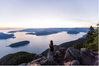
-St. Mark's Summit is part of the Howe Sound Crest Trail that spans over 30km from Cypress to a point along the Sea to Sky Highway near Porteau Cove. The section of the trail that St. Mark's Summit is on starts from Cypress Mountain which is the first mountain along this route and offers spectacular views of Howe Sound on a clear day.
-From the Cypress Mountain downhill parking lot, head north towards the nearby chairlift and look for the Howe Sound Crest Trail sign. The trail follows alongside the several ski runs until a sign that points to the right to the Howe Sound Crest Trail. Follow this trail uphill until it merges onto a wider ski run and veer to the left towards a large green water tower. Just before the tower, go right onto a trail and walk uphill through the trees.
-After a short hike, the trail reaches a gravel road. Go left at the gravel road and continue as a short distance later the road narrows and becomes a trail. You are now on the Howe Sound Crest Trail and this route will take you to St. Mark's Summit. About 10 minutes after entering the forest, you reach a junction with a map of the area. Just beyond the mapboard is a clearing with a view of the Lions off in the distance. Continue along the trail as it winds along the mountainside and gradually heads uphill.
-The trail emerges briefly into a small meadow and crosses two bridges before continuing uphill. A few minutes later, the climb begins to steepen as the trail goes through a series of switchbacks. The path then begins to level and a brief downhill section along the top of the ridge offers some relief from the steep hill on a warm day. The relief is short lived as the trail climbs again through another series of switchbacks that are steeper than the previous ones.
-As the trail levels out, you have reached the upper region of St. Mark's Summit. Continue another short distance over the rocky terrain until you reach a point where you can see Unnecessary Mountain and the Lions off in the distance. Do not descend but instead, go left to a scenic viewpoint of the area. On a clear day, you can see views of Howe Sound, the Tantalus Range, and even the Gulf Islands and Vancouver Island off in the distance. There are a few other viewpoints along the short ridge that are worth checking out before making your journey back towards Cypress Mountain.
-After resting and soaking in the gorgeous views over lunch, make your way back to the trail and retrace your steps heading back downhill through the switchbacks towards Mt. Strachan Meadows and eventually the parking lot at Cypress Mountain.
-Website: https://www.outdoorvancouver.ca/featured-trail-st-marks-summit/
2.Soames Hill
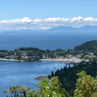
-Soames Hill is a steep hike that is located in Gibsons near Shirley Macey Park and has incredible views that look across towards Keats Island and out towards the Strait of Georgia. The hike follows a steep set of stairs, offering a good workout that is rewarded with several beautiful views.
-There are two locations that the you can start the trail from, either from Bridgeman Road or Esperanza Road. Both routes will go to the bottom of the Green trail, then follow the Green trail to the top of the hill. This trail description begins from Bridgeman Road but both routes are similar distances and the trails are well marked with maps.
-From Bridgeman Road, walk past the yellow gate and follow the Yellow trail into the forest. The beautiful west coast rainforest is lush with vegetation, including moss and sword ferns that blanket the area.
-Watch for a sign with a trail junction on your left marking the start of the Green trail. Go left and follow the Green trail as you begin to climb the steep stairs on the hillside. The trail weaves back and forth as you continue to gain elevation while occasionally stopping to catch your breath and let people by who are descending.
-As the trail begins to level, you reach a junction. Go right and follow the trail for a short walk that takes you up onto a rock with a viewpoint. The view offers glimpses across the water towards Keats Island, however the better viewpoints are at a high point further up the trail.
-Follow the trail back down to the junction and this time go left and continue hiking up the trail. The trail will reach another junction, go left and follow the one that continues up a steep hill. Within a few minutes, a viewpoint appears on your right. Continue hiking up the hill, watching your step over the smooth rock and checking the views off to the right.
-Eventually, the trail reaches a final viewpoint that looks out towards Keats Island. The town of Gibson can also be seen from the viewpoint as you peer down the coastline and out towards the Strait of Georgia.
-After enjoying the view, follow the trail back downhill the way you came, being careful as you step on the slippery rock. At the first junction, go right and follow the trail up a small incline before it descends again through the forest. Pass the sign at the second junction and begin to descend down the steep stairs. The descent is quick as you reach the bottom, returning to the Yellow trail. Go right and follow the Yellow trail back to the Bridgeman Road parking area.
-Location: From the traffic light at the junction of Highway 101 and North Road in Gibsons, proceed 1.9 kms along North Road toward the Langdale ferry terminal. Turn right onto Chamberlin Road and after 200 metres turn left onto Bridgeman Road. 300 metres along Bridgeman is the park entrance. Along Chamberlin is another park entrance on Esperanza.
-TEL: (604) 885-6800
-Website: https://www.vancouvertrails.com/trails/soames-hill/
3.Plumper Cove Marine Provincial Park
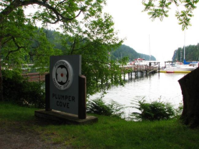
-Plumper Cove Marine Provincial Park is a provincial park in British Columbia, Canada. The park is located on Keats Island in Howe Sound, northwest of Vancouver, British Columbia.
-It is one of the oldest marine parks on the BC coast, and a popular anchorage in the summer months. The 57-hectare park is located on the northwest shore of Keats Island.
-The park has a well maintained hiking trail system, a grassy upland picnic area and forested walk-in campsites. The trail system consists of 'Keats Loop' which leads to the top of a bluff to a lookout, and then there is a 2 km (1 mi) trail which leads to Keats' Landing, the final segment of which can be travelled either by dirt road or trail. The 2 km (1 mi) trail is of intermediate level, easy to hike when not laden with camping gear, but somewhat arduous when hiking in with several days worth of camping supplies. It is roughly 1 km (1 mi) uphill and 1 km (1 mi) downhill either direction, and somewhat near the trail's middle it peaks near the lookout.
-There are only two ways for the public to access the park; by marine access or by hiking in. Travellers can take BC Ferries from Horseshoe Bay to Langdale, then board the Stornaway II which makes infrequent trips to Keats' Island and Gambier Island, then hike roughly 2 km (1 mi) to the campground. The trail from Keats Landing to Plumper Cove Marine Park is NOT bike friendly, and most trails on the island are similarly challenging - bicycles are not recommended but good walking shoes will get you where you need to go! Alternately, via marine access, one with their own boat can navigate and pay moorage fees at the park dock. Several water taxi services are available from Gibsons to Plumper Cove Marine Park, but these are somewhat erratic and do not operate on a regular schedule, sometimes requiring a charter.
-The park is known for its quiet and natural surroundings. Unlike many other provincial campgrounds which have vehicle access, traffic by locals there to drink and make loud noise is limited. Occasionally people from Gibsons, British Columbia or those who have cabins on Keats Island will park a barge or tie together a series of boats and have a private flotilla party, although this is rare and usually only occurs on peak long weekends. Due to the natural surroundings, lack of vehicle access, and dedication or investment in a marine vehicle to get to the park, the park is lovingly referred to by those who frequent it regularly as "the best campground in BC". Those from Vancouver, British Columbia who frequent the park tend to go back every year on the same weekends at the same time, and tend to not advertise to their fellow city dwellers about the park in order to keep it private and from it getting too busy.
-From September 24 to May 15, the park does not charge camping fees, but has limited services available. Normally, during peak summer months, the camping fee is $16 per night per party (party up to four). There are group campsites available which are double sites for larger parties. Group picknicking services are available by private reservation only. Moorage at a buoy costs $12 per night, and moorage at the dock costs $2.00 per metre per night. Docking and moorage fees only apply after 6pm. During the winter months most services are free of charge. Garbage service is very limited (if at all) and visitors should plan to pack out anything they may bring.
-The park has potable water available from a hand pump only from May 15th to Sep 15th and the pit toilets are open year around.
-Due to storm damage in the winter of 2006 the dock at the Park was destroyed, and replaced in 2007.
-Address: Plumper Rd, Gibsons, BC V0N 1V0
-Phone: (604) 885-3714
-Website: http://bcparks.ca/explore/parkpgs/plumper/
VI.History
-Indigenous peoples
The name for Bowen Island is Nex̱wlélex̱m in the Squamish language of the Squamish people. The Squamish peoples used and occupied the area around Howe Sound including Bowen Island. Areas such as Snug Cove and a few other parts of the island were used as campsites for hunting and gathering trips.
Historically they would use the warmer spring and summer months to travel to resource gathering sites and move from their permanent winter villages. Bowen Island has a traditional name in the Squamish language, Xwlíl’xhwm, translating to "Fast Drumming Ground", although some authors attribute the name to the sound made by the ocean as it passes through the tiny pass between the Island’s northern point and Finisterre Island. The tide rushing in and out is reminiscent of the sound of drums beating quickly. The name "Kwém̓shem" is used for Hood Point. Bowen is still used by people from Squamish and Musqueam for deer hunting.
Into the 20th century Bowen Island was actively used by Squamish people for deer and duck hunting, fishing and, later, wage jobs. In conversations with Vancouver archivist Major Matthews in the 1950s, August Jack Khatsahlano recalled knowing several Squamish who worked for whalers on the island at the turn of the 20th century. In a conversation with City of Vancouver archivist JA Matthews, Khatsahlano recalled deer hunting on Bowen, saying that at one time he took the biggest deer in British Columbia from the island, weighing in at 195 pounds (88 kg).
-Post-colonization
When Spanish explorers arrived on the west coast of Canada, they named many of the features of what is now the Strait of Georgia. Bowen Island was called Isla de Apodaca (after the Mexican town of Apodaca, in northeast Nuevo León state – itself named after a benevolent bishop, Salvador de Apodaca y Loreto) by the Spanish Captain José María Narváez in July, 1791. In 1860 Cpt. George Henry Richards renamed the island after Rear Admiral James Bowen master of HMS Queen Charlotte.:58
In 1871 homesteaders began to build houses and started a brickworks, which supplied bricks to the expanding city of Vancouver. Over the years, local industry has included an explosives factory, logging, mining, and milling, although there is no heavy industry on the island at present.
The island was named by Captain Richards for Rear-Admiral James Bowen who was the master of HMS Queen Charlotte.:25
-20th century
In the first half of the 20th century, life on Bowen was dominated by a resort operated by the Terminal Steamship Company (1900 - 1920) and the Union Steamship Company (1920 - 1962). These companies provided steamer service to Vancouver, and the Horseshoe Bay - Bowen Island Ferry began in 1921. When the Union Steamship resort closed in the 1960s the island returned to a quiet period of slow growth. In the 1940s and 1950s, the artists' colony called Lieben was a retreat for many famous Canadian authors, artists, and intellectuals including Earle Birney, Alice Munro, Dorothy Livesay, Margaret Laurence, A.J.M. Smith, Jack Shadbolt, Eric Nicol and Malcolm Lowry, who finished his last book, October Ferry to Gabriola, there. In the 1980s, real estate pressures in Vancouver accelerated growth on Bowen and currently the local economy is largely dependent on commuters who work on the mainland in Greater Vancouver. Prior to becoming a municipality, Bowen Island was part of the Sunshine Coast Regional District, made up of small communities and municipalities. However, in the 1980s the island transferred to the Greater Vancouver Regional District after a campaign organized by developers and realtors. A campaign to make the island an autonomous municipality was successful after two referendum attempts.
In 1999 the Bowen Island Municipality was incorporated, becoming the second "island municipality" in BC. The first was Saltspring Island which was incorporated in 1873 and dissolved by the BC legislature 10 years later.
VII.Other information
-Roads and Infrastructure
The mandate for the Roads Program is to maintain, repair, rehabilitate and construct the Municipality’s above-ground infrastructure to provide a safe, efficient and sustainable network of roads, ditches, culverts, storm drainage collection, bridges, sidewalks, roadside trails and docks. Throughout the year, Bowen Island’s infrastructure is monitored on a weekly basis so as to ensure that road conditions are kept to a defined standard. A number of seasonal programs are also implemented on an annual basis including winter and summer maintenance and the capital renewal program.
The Public Works Department is also responsible for the maintenance of the Municipality’s three public docks; Snug Cove North, Snug Cove South and Mount Gardner.
The Municipality maintains approximately 135 lane kilometres to ensure the mobility and safety of the community. Road maintenance includes but is not limited to street cleaning, ice and snow control, installation and maintenance of ditches, culverts and storm sewer inlets, pothole patching, line marking, and vegetation control.
In addition to routine road-related maintenance, the Municipality re-paves approximately 2 km of roads annually. Well maintained roads contribute to the safe movement of people and goods.
Street lights are owned by BC Hydro and paid for by the Municipality. The posted speed limit in effect all over Bowen Island is 30 to 40km. Stop when you see the school bus with its lights flashing. Expect to meet slow moving machinery, horse riders, cyclists, pedestrians, work crews and, in winter, snow plows and sand trucks.
-Website: https://www.bowenislandmunicipality.ca/roads-and-infrastructure
VIII.Contact information
-Government
Councillors:
-Sue Ellen Fast
-David Hocking
-Michael Kaile
-Alison Morse
-Maureen Nicholson
-Rob Wynen
Mayor: Gary Ander
-E-mail bim@bimbc.ca
-Telephone 604-947-4255
-Address 981 Artisan Lane Bowen Island, BC V0N 1G2
-Public Works Administration 2nd Floor - 430 Bowen Island Trunk Road (entrance off Cardena, above the Library)
Email: https://www.bowenislandmunicipality.ca/contact-us
