Minnedosa, Manitoba 作者: 来源: 发布时间:2021-12-02
I.Population and Area
-Area
Land: 15.2 km2 (5.9 sq mi)
-Population (2016)
Total: 2,449
Density: 161.1/km2 (417/sq mi)

II.Natural Geography (environment and esources)

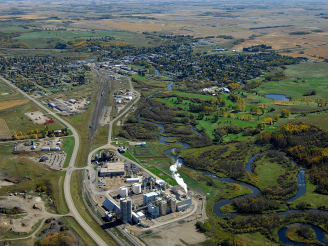
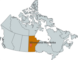
-Minnedosa is a town in the southwestern part of the Canadian province of Manitoba. Situated 50 kilometres (32 mi) north of Brandon, Manitoba on the Little Saskatchewan River. The town's name means "flowing water" in the Dakota language. The population of Minnedosa reported in the 2006 Statistics Canada Census was 2,474. The town is located in the Rural Municipality of Minto and bordered to the south by the Rural Municipality of Odanah.

-Minnedosa has a humid continental climate (Köppen dfb) typical of southern Manitoba. As a result of its far inland position at a relatively high latitude, winters are extremely cold with a January mean of below −17 °C (1 °F). In the relatively short summers Minnedosa experiences warm and sometimes hot temperatures due to warmer continental air masses. It is prone to cold nights year-round, with every single month having recorded air frost.
-Incorporated in 1883, Minnedosa is now a thriving and picturesque town of 2,500 people, situated at the junction of Provincial Highway #10 and Yellowhead Highway #16, in the Province of Manitoba. It is 30 minutes north of the City of Brandon and 30 minutes south of Riding Mountain National Park.
III.ECONOMY
-Average Hourly Rate in Minnedosa, Manitoba: C$15.52
-Website: https://www.payscale.com/research/CA/Location=Minnedosa-Manitoba/Salary
IV.Industrial Characteristics
-10% of the jobs in the region are in the primary sector of Agriculture, forestry, fishing and hunting. • 6% of the jobs are in the secondary sectors of Construction and Manufacturing. • 84% of the jobs are in the tertiary sector. • 40% of the jobs are in sectors traditionally funded by government (Education, Healthcare, and Public administration)

-Website: https://www.gov.mb.ca/jec/ecprofiles/pdfs/southwest/minnedosa_sla.pdf
V.Attractions
1.Agricultural Display Building – Octagon Building

-The Octagonal Building is a Municipal Heritage Property located on a portion of the Exhibition Grounds in Prince Albert. The property features a unique 8-sided, two-storey wooden structure, which was constructed in 1905.
-The unique octagon shaped building is a treasure to the Heritage Village. This historic display building is one of only three left in Manitoba and was donated to the village by the local Agricultural Society for restoration.
-After sitting on a loose stone foundation at the Minnedosa Agricultural Grounds for over one hundred years, the building was in dire need of repair to save it from collapsing in on itself. The building has been saved and has been restored back to its former glory. New cedar shakes have been installed on the roof, and windows have been installed in the old window openings that were closed in back in the 1940’s or 1950’s. The exterior restoration was completed in 2008, interior and landscaping in 2009.
-The octagon display building has been designated a heritage site and is a gem of the Heritage Village.
-Locatino: Exhibition Grounds, Prince Albert, Saskatchewan, S6V, Canada
-Website: https://www.historicplaces.ca/en/rep-reg/place-lieu.aspx?id=1295
2.Cadurcis Home

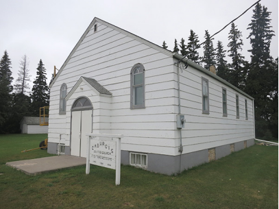
-The Cadurcis House was moved from the Cadurcis district (west of Minnedosa) to the Heritage Village in 1999 and completely restored to a comfortable, cozy, family home. It was newly painted in 2012. It is furnished with period pieces and is a definite must see!
-The original part of this house was built around 1910, with latest additions constructed about 1915. The farm was bought by the Dickie family in 1917, with water works and an electric Delco plant installed at that time. Frank and Christie Dickie lived there from their marriage in 1921 until 1945. The farm was then sold to Laurie and Jenny Thierry.
-The house features 3 bedrooms upstairs and a 2nd floor balcony off the master bedroom providing a view of the Little Saskatchewan River, nature trails and bison compound. There is a traditional open-air covered front porch. The 1st floor of the house includes a closed-in porch, large kitchen with stove and fainting couch, kitchen pantry, dining room and parlour. Other features include hardwood floors, leaded glass windows with character exterior and interior "gingerbread” & "filligrade”. It has a heritage designation.
-The first Presbyterian church in this part of the Rural Municipality of Saskatchewan (now part of the Rural Municipality of Oakview) was established in 1883, before which services were held in private homes. A modest structure made of logs, in 1904 the church was replaced by a wood frame building measuring 38 feet long and 26 feet wide. Services and meetings were held in the Cadurcis School until the building was ready. A shelterbelt of spruce trees was planted around the church in 1927, soon after the church became part of the United Church of Canada. During a violet electrical storm on 29 July 1951, the church caught fire and was destroyed, but the piano, organ, and pulpit were saved. Services were held in a nearby shed from August to November, when it became too cold to continue. Meanwhile, construction of a new church began in earnest; a concrete basement was poured and it was used for services while the upper level was being built. The first service in the upper level was held on 10 February 1952. A dedication service was held on 15 June 1952. The original siding was replaced with the present lapboard siding in 1973. The roof was reshingled in July 2000.
3.Havelock School 1910

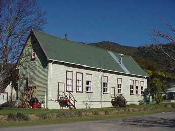
-The Havelock School takes visitors back to days of multi-grade classrooms – a one room school house, complete with desks, books, maps, etc. A large wood stove heated the schoolhouse at the time. Many Christmas concerts and recitals took place in the schoolhouse – it was the hub of a rural community district.
-Havelock School District was organized in 1909-10 because of the increase in the population in the area a few miles south of Minnedosa, where a large number of Swedish families and other nationalities had recently settled. The school was built in 1910 at a cost of $1650 and opened for classes in April 1911. The school was located 3 miles south of Minnedosa on the west side of what is now Provincial Road 262. Because of the vote for a larger school district the school was closed in 1966.
-Mrs. Vint was the last teacher to have the assignment at the Havelock school. Three generations of students had attended the school since 1910. The school was sold to the Minnedosa Museum for $1.00 and, in 1967, was moved into town and located beside the original cinder block Museum on 2nd Ave. N.W. (beside the Masonic Hall). The old school remained on that site until September 22, 1997, when it was moved by Minty Movers, to the site of the newly formed Heritage Village, where it was put onto a new cement foundation.
-The school and it’s contents represent the early years of the 1900’s classroom. It’s shelves and cupboards contain records from the many schools that were part of the surrounding district’s history.
-It is open to the public approximately 8 weeks a year, from July 1st to the September long weekend, and at other times by appointment. Country schools no longer exist but having the original Havelock School located and maintained in our Heritage Village will help to preserve our history and memories of a time gone by.
-Website: http://www.theprow.org.nz/people/rutherford-and-pickering-at-havelock-school/
VI.History
-Prior to the arrival of Europeans in the area of Minnedosa, the land was primarily traveled and used by the nomadic Ojibway, Cree, Assiniboine, and Sioux peoples. John Tanner was the grandson of John Tanner who had been raised by a Shawnee. He was an American settler who arrived in the area in 1869. The younger Tanner was the first Métis settler in the area and ran a ferry service across the Little Saskatchewan River. When a bridge was built in 1879, the ferry became obsolete and at the same time, a small town, Tanner's Crossing, was started nearby. John Armitage moved to the area around this time in 1877, and began to build a sawmill and gristmill. He joined together with Tanner to lay out a new town site and eventually Armitage had accumulated 3,800 acres (15 km2) of property. Tanner named the new town Minnedosa, from the Dakota word mnidúza meaning "flowing water".
-Although Minnedosa once hoped to be a site of a river crossing for the Canadian Pacific Railway's transcontinental railway, the honour was initially given to Rapid City, while the actual site of the railway was later settled on a site much further south creating the city of Brandon. In 1883 Minnedosa was incorporated as a town, it had experienced a period of growth from settlement schemes put forth by the Canadian government. As Minnedosa became a town, this coincided with the actual arrival of the railway in 1883, bringing about more growth for the now quickly growing settlement.
-A dam was proposed in 1907 and approved in December of the same year by the Government of Canada. It was built on the Little Saskatchewan River near the town. After several delays, the dam was completed in 1912, creating Minnedosa Lake. Water first flowed over the spillway on April 10, 1912. Minnedosa was the second community in the Province of Manitoba to generate its own hydroelectric power. An earlier project in 1900 was also on the Minnedosa River and supplied power to the town of Brandon, Manitoba. Initially privately owned, the generation plant was taken over by the Manitoba Power Commission in 1920 and replaced by a diesel generation plant and by 1930, power from the provincial grid. The lake was used as a source of water for the town, for recreation, and for supplying the engines of the Canadian Pacific Railway. On May 4, 1948 the spillway of the dam failed due to erosion of structure, and the resulting flood damaged many homes and businesses in the town. The spillway was not repaired until 1950 by the Prairie Farm Rehabilitation Administration.
-Since 1981 the Minnedosa Ethanol Plant has been producing ethanol to be blended into gasoline, as of late 2007 it has been expanded into one of the largest ethanol facilities in Canada. This plant is owned and operated by Husky Energy.
VII.Other information
-The Minnedosa settlement began when John Tanner developed a stopping place along the Carlton Trail at a crossing of the Little Saskatchewan River in the early 1870’s. This stopping place became known as "Tanner’s Crossing” which soon attracted hundreds of pioneers and fur traders as they passed through on their way west. A North West Mounted Police outpost was established in 1875. With law and order in the area, settlers began to arrive, and a small town was established. The first bridge was built over the river in 1879 and railway tracks were built into and through the area. The town was later renamed "Minnedosa” which is a Sioux word that translates as "flowing water”.
-Incorporated in 1883, Minnedosa is now a thriving and picturesque town of 2,500 people, situated at the junction of Provincial Highway #10 and Yellowhead Highway #16, in the Province of Manitoba. It is 30 minutes north of the City of Brandon and 30 minutes south of Riding Mountain National Park.
-The Little Saskatchewan River flows through the town and feeds Minnedosa Lake which is a beautiful recreational area with beach, campground, walking trails and more. Situated in a valley, the town offers many other recreation facilities for summer and winter, a hospital and clinic with six doctors, K-12 schools and an adult learning centre, and is a regional service centre for the surrounding communities and rural residents.
VIII.Contact information
-Government
Mayor: Ray Orr
-Town of Minnedosa Administration Office
Address: Civic Centre 103 Main Street S., Minnedosa, Box 426, Minnedosa, MB R0J 1E0
Phone: 204-867-2727
Fax: 204-867-2686
Email: minnedosa@minnedosa.com
