Killarney, Ontario 作者: 来源: 发布时间:2021-12-02
I.Population and Area
-Area
•Land: 1,653.32 km2 (638.35 sq mi)
-Population (2016)
•Total: 386
•Density: 0.2/km2 (0.5/sq mi)
II.Natural Geography (environment and resources)
-Killarney is a municipality located on the northern shore of Georgian Bay in the Sudbury District of Ontario, Canada. Killarney is commonly associated with Killarney Provincial Park, which is a large wilderness park located to the east of the townsite which occupies much of the municipality's expanded boundary.
-In addition to the community of Killarney itself, the communities of Hartley Bay and Bigwood, and the ghost towns of French River, Collins Inlet and Key Harbour, are also located within the municipal boundaries.
-The eastern end of the La Cloche Mountain Range is also located within the municipality of Killarney.
III.ECONOMY
-Median household income:$58,368

IV.Industrial Characteristics
-The Killarney area's economy is based primarily on tourism, consisting mainly of wilderness lodges, campgrounds and retail services geared toward campers and other visitors to Killarney Provincial Park.
-A community museum, the Killarney Centennial Museum, is located in Killarney adjacent to the municipal government offices.
-Although not officially part of the Sudbury East region, Killarney participates in the regional Sudbury East Planning Board with the municipalities of French River, St. Charles and Markstay-Warren.
-Killarney Provincial Park is also home to the Killarney Provincial Park Observatory.
-Economic Development
•The Municipality wishes to have a measured and well-informed approach to growth and development. Since the most recent Economic Development Plan was created in 2002, the Council decided to have the plan updated in 2014.
The new Plan will guide the decisions and actions of Council and staff by:
identifying productive goals
outlining the strategies and resources necessary to reach these goals
An effective Plan will help to lead activities such as:
gathering background information for future grant applications,
prioritizing projects, and
- implementing small projects that can prepare the way for larger ones
The process of updating the Economic Development Plan has been completed. The firm of ClearLogic Consulting Professionals has guided the Plan’s development, together with the Municipality’s Economic Development Steering Committee.
-Website: http://www.municipalityofkillarney.ca/economic-development/economic-development
V.Attractions
1.Crack Trail

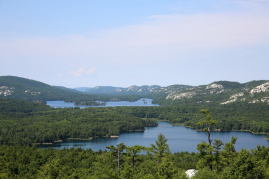
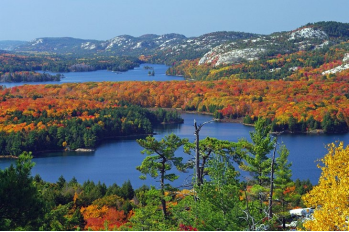
-The Crack Trail (yes, that’s its official name) follows an old logging road before its rocky inclines grow steeper as the trail progresses. Hikers can snack on wild blueberries along the trail before reaching the unforgettable ridge summit three to four hours later. At the top of a breathtaking lookout point, hikers are treated to a truly epic panorama: the La Cloche mountain range, vibrant pine forests and deep glacial lakes shimmer under big Killarney skies. Don’t forget your camera—this is an iconic view that you'll want to remember.
-Address: Killarney Provincial Park, Killarney, Ontario, P0M 2A0
-Telephone Number: 705-287-2900
2.Killarney Provincial Park

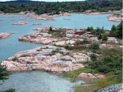
-Killarney Provincial Park is on Georgian Bay, in the Canadian province of Ontario. It encompasses a vast wilderness area of wetlands, forests and mountains. La Cloche Silhouette Trail climbs the white quartzite ridges of La Cloche Mountains. Cranberry Bog Trail crosses bogs and swamps. Canoe routes connect the park’s numerous clear lakes, such as George Lake. Glacier-sculpted pink granite cliffs frame the coastline.
-Location: 960 Highway #637, Killarney, Ontario P0M 2A0 Canada
-TEL: +1 705-287-2900
3.Killarney East Lighthouse

-Located roughly seventy-five kilometres southwest of Sudbury, the town of Killarney is situated at the trip of a granite peninsula that juts out into Georgian Bay. A long narrow channel separates Killarney from George Island, which protects the town from direct exposure to Georgian Bay.
-The Ojibwa called the place Shebahonaning, meaning “here is a safe canoe channel,” and early traders and explorers used the channel on their voyages between Georgian Bay and Lake Superior. Etienne Augustin de la Morandiére, became the first white settler in the area when he established a trading post on the channel in 1820, and the crops and cattle he raised helped Killarney become an important fishing community on the north shore. Access to the town was limited to boats until Highway 637 was completed in 1962.
-The contract that saw the six Imperial Towers erected on Lake Huron and Georgian Bay in the 1850s was also to cover the construction of four lighthouses to mark the North Channel, which runs between the northern end of Georgian Bay and Lake Superior, but cost overruns led to the postponement of the North Channel lights. Finally, in 1866, the government built five nearly identical lights along the North Channel: one on Clapperton Island, two at Little Current, and two at Killarney.
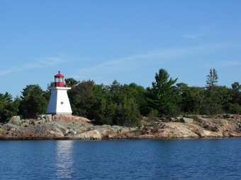
-Known originally as Red Rock Lighthouse and Partridge Island Lighthouse, the two Killarney lights are now listed as Killarney East and Killarney Northwest. Square, wooden towers, which measured twenty feet from their base to the top of their birdcage lanterns, were built at Red Rock Point and Partridge Island. Both towers were placed on bare rock, which gave the light at Red Rock a focal plane of eighty feet and that on Partridge Island a focal plane of thirty feet.
-Website: https://www.lighthousefriends.com/light.asp?ID=1381
4.Philip Edward Island

-The 50-kilometre trip circumnavigates the triangular Philip Edward Island, and most people do it in a counter-clockwise direction, due to the prevailing winds. The first section-running from the southwestern corner of the island to the southeastern-is exposed to the big water of Georgian Bay, which is why many paddlers do this tour in a kayak. However, there are plenty of inlets and bays to escape the high winds, which makes it canoe-friendly as well.
-The paddling along this stretch is classic Georgian Bay-aqua-clear water and humps of pink granite capped by windswept pine-and the La Cloche range is visible to the east. If you have the time, check out some of the small islands offshore. At Beaverstone Bay, the route heads north, past a cluster of small islands and along an irregular shoreline that can humble even the most experienced navigator. Then the route turns west along Collins Inlet, a protected 20-kilometre channel that leads you directly back to the access point. This was a preferred waterway for the First Nations people, who left their mark on a slab of granite with an assortment of ochre pictographs. In 1615, Samuel de Champlain also paddled here, noting in his journal the inhabitants' colourful tattoos, made by having their skin slashed open and infected with charcoal and dye.
-Address: 1076 Hwy 637, KILLARNEY, Ontario. Canada, P0M 2A0
-TEL: +1.705.287.2828
VI.History
-The area was named after the town of Killarney in Ireland.
-The area was first settled in 1820 by French Canadian fur trader Étienne Augustin de Lamorandière and his Anishinaabe wife Josephte Saisaigonokwe, who established a trading post named Shebahonaning (canoe passage) at the townsite.
-Killarney was operated as a fishing camp by the Fruehauf Trailer Company in Detroit, Michigan. Roy Fruehauf, president of the company from 1949 to 1961, was primarily responsible for operating Killarney. Clients and guests would be flown in via Mallard sea planes for vacations during the warmer summer months.
-Highway 637, connecting Killarney to Highway 69, was constructed in 1962. Prior to its construction, the community relied primarily on water transport via Georgian Bay and the North Channel.
-The current municipality was incorporated on January 1, 1999, when the Ontario provincial government expanded the boundaries of the township of Rutherford and George Island, the former governing body of the community of Killarney. The municipality was also transferred from the Manitoulin District to the Sudbury District at that time. In 2006, the municipality was enlarged again when it annexed the unorganized mainland portion of Manitoulin District.
-The larger municipality of Killarney now encompasses virtually all of Killarney Provincial Park and the French River delta, and in fact extends all the way to Highway 69, over 70 kilometres from the townsite. Despite the municipality's geographic size, however, most of its population continues to reside in the community of Killarney itself, although smaller settlements also exist at Hartley Bay and Bigwood.
-The Municipality of Killarney has used a two-ward electoral system since amalgamation in 1999, which brought together the original town with what had been large, unorganized townships. In July 2005, there was a realignment of ward boundaries, which extended the limits of Ward 1 to include properties on the Highway 637 corridor (which had previously been part of Ward 2).
-In October 2012, the Municipality received a petition requesting that Council return the wards to their original state. In December 2012, Council passed a resolution defeating the request. Later that month, an appeal was submitted to the Ontario Municipal Board (OMB) claiming that the present ward system and councillor representation is unfair.
-The Municipality received correspondence from a number of ratepayers, some of whom supported and some of whom opposed a change in ward boundaries, the adoption of a Councillor-at-large electoral system, and/or a change in the current composition of council.
-In April 2013, Council created an Ad Hoc Committee to study the effects of changes in the municipality’s electoral structure. The Committee, composed of Councillors and staff, concluded its investigations in August 2013, and the Council subsequently accepted the Committee’s recommendations to retain the present two-ward system, but change the composition of Council to 3 councillors from Ward 1, 2 councillors from Ward 2, and a mayor elected at-large.
-In October 2013, the OMB held a public hearing in Killarney village regarding the ward boundaries and electoral system issues. In November 2013, the Board issued its decision in the case, in favour of the Municipality. A copy of the Ad Hoc Committee’s report as well as the full text of the OMB’s decision can be found here.
VII.Other information
-The primary road access to Killarney is via Highway 637. The town is also served by the small Killarney Airport. It is also possible to travel to Killarney by boat, usually from the town of Little Current.
-Community
The Killarney Community Centre Society (KCCS) is a body of volunteers from the community that are elected annually at the Annual General Meeting. These volunteers help set policies and usage of the facilities at Killarney and also fund programs, special events, equipment & capital projects. The board of directors work in conjunction with Recreation staff to provide programs and services to the community.
-Website: https://killarneycentre.ca/about/the-society/
VIII.Contact information
-Government
•Type: Town
•Mayor: Ginny Rook
-Governing Body: Killarney Municipal Council
•MP: Marc Serré (Liberal)
•MPP:France Gélinas (NDP)
-Public Works Department
•Superintendent – Tony Nuziale
•Tel: 705-287-1040
•Email: tonynuziale@municipalityofkillarney.ca
•Public Works Clerical Assistant – Amanda Tyson
•Tel: 705-287-1040
•Email: atyson@municipalityofkillarney.ca
•Public Works Foreman – Robert Roque
•Tel: 705-287-1040
•Public Works Assistant Foreman – Adam Tyson
•Tel: 705-287-1040
-Website: http://www.municipalityofkillarney.ca/staff-directory
