Dawson City, Yukon 作者: 来源: 发布时间:2021-12-01
I.Population and Area
-Population in 2016: 1,375
-Density: 42.4/km2 (110/sq mi)
-Total Area: 32.45 km2 (12.53 sq mi)
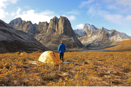
II.Natural Geography (environment and resources)
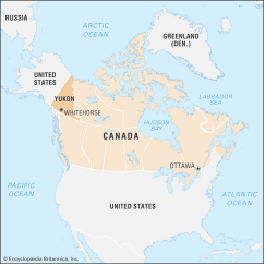
-Dawson City lies on the Tintina Fault. This fault has created the Tintina Trench and continues eastward for several hundred kilometres. Erosional remnants of lavaflows form outcrops immediately north and west of Dawson City.
-Dawson City, officially the Town of the City of Dawson, is a town in the Canadian territory of Yukon. It is inseparably linked to the Klondike Gold Rush (1896–99). Its population was 1,375 as of the 2016 census, making it the second largest town of Yukon.
-Dawson City is an eclectic and vibrant northern community on the banks of the Yukon River. We boast a mixture of First Nations Heritage and Gold Rush History blended with an active Gold Mining and Tourism Industry as well as a thriving Arts scene. In brief, we’ve got everything you’re looking for in a northern town!
-Dawson’s past is marked by Beringia, an Ice Age period which formed our unique landscape and the treasures they contain, the Tr’ondëk Hwëch’in, who have called this area home for centuries, as well as the Klondike Gold Rush, that put this town on the tongue of stampeders worldwide.
-Dawson City, officially the Town of the City of Dawson, is a town in the Canadian territory of Yukon.
III.ECONOMY
-Largest age group: 30-34
-Average Household Income: $74 609
-Average Home Value: $293 754
-Average Monthly Rent: $733
-Average commute: drive/walk less than 15 minutes
-Average weeks worked per year: 38
IV.Industrial Characteristics
-Today, Dawson City's main industries are tourism and gold mining.
-Energy
•Electricity is provided by Yukon Energy Corporation (YEC). Most of the grid power is hydroelectric power through the north-south grid from dams near Mayo, Whitehorse and Aishihik Lake. After the local hydroelectric power plant for the gold dredges was shut down in 1966, YEC provided electrical power from local diesel generators. In 2004 YEC connected Dawson to its grid system. Since then the diesel generators function as a backup to the grid.
-Gold mining
•Gold mining started in 1896 with the Bonanza (Rabbit) Creek discovery by George Carmack, Dawson Charlie and Skookum Jim Mason (Keish). The area's creeks were quickly staked and most of the thousands who arrived in the spring of 1898 for the Klondike Gold Rush found that there was very little opportunity to benefit directly from gold mining. Many instead became entrepreneurs to provide services to miners. Dredge No. 4
•Starting approximately 10 years later, large gold dredges began an industrial mining operation, scooping huge amounts of gold out of the creeks, and completely reworking the landscape, altering the locations of rivers and creeks and leaving tailing piles in their wake. A network of canals and dams were built to the north to produce hydroelectric power for the dredges. The dredges shut down for the winter, but one built for "Klondike Joe Boyle" was designed to operate year-round, and Boyle had it operate all through one winter. That dredge (Dredge No. 4) is open as a National Historic Site of Canada on Bonanza Creek.
•The last dredge shut down in 1966, and the hydroelectric facility, at North Fork, was closed when the City of Dawson declined an offer to purchase it. Since then, placer miners returned to the status of being the primary mining operators in the region until recently. In 2016, Goldcorp announced a takeover of Kaminak Gold's Coffee Project south of Dawson. This marked a shift in the region, drawing the interest of the major gold mining companies in the Yukon. In 2017, Newmont Mining Corporation, Barrick Gold and Agnico Eagle Mines Limited have all committed significant investment, engaging in the exploration of properties across the Central Yukon.
-Tourism
•Most of Dawson's buildings have the appearance of 19th-Century construction. All new construction must comply with visual standards ensuring conformity to this appearance
•There are eight National Historic Sites of Canada located in Dawson, including the "Dawson Historical Complex", a National Historic Site encompassing the historic core of the town.
•The Downtown Hotel at Second Avenue and Queen Street has garnered media attention for its unusual Sourtoe Cocktail, which features a real mummified human toe. The hotel and the toe received increased attention in June 2017 after the toe was stolen; it was soon returned to the hotel by mail along with a written apology.
•Bonanza Creek has two National Historic Sites; the Discovery Claim and the Dredge No. 4.
•Tr'ochëk is the site of a traditional Han fishing camp on the flats at the confluence of the Klondike River and Yukon River. The site is owned and managed by the Tr’ondëk Hwëch’in First Nation. In addition to the fishing camp remains, the site includes traditional plant harvesting areas and lookout points.
•Diamond Tooth Gertie's Gambling Hall puts on nightly vaudeville shows during tourist season, from May to September.
V.Attractions
1.Tombstone Territorial Park
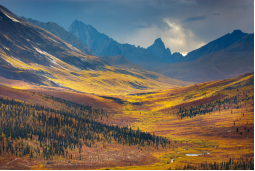
-Tombstone Territorial Park is a territorial park in the Yukon, one of three territories in Canada. It is located in central Yukon, near the southern end of the Dempster Highway, stretching from the 50.5 to the 115.0 kilometer marker. The park protects over 2100 square kilometers of rugged peaks, permafrost landforms and wildlife, including sections of the Blackstone Uplands and the Ogilvie Mountains. The Park is named for Tombstone Mountain's resemblance to a grave marker.
-The area is geologically unique and ecologically diverse. It is bisected by the divide separating waters flowing into the Yukon River and eventually the Bering Sea from those flowing into the Mackenzie River and eventually the Beaufort Sea. The divide is part of an igneous belt of granitic and syenitic rock, known as the Cretaceous Tombstone Suite, that stretches from Fairbanks, Alaska, to the Ross River. Multiple glaciations intruded into the region from the East, separating it from areas to the north and west, known as Beringia, that were not glaciated, and creating a pocket of rugged terrain. North of the divide, the margins of prior glaciations give way to much gentler permafrost landforms that escaped glaciation, with ice margin formations such as pingos, moraines, ice-wedge, polygons and frost mounds.
-The Park protects diverse flora and fauna, including five big game species Dall's sheep, two species of caribou, moose, black bears, grizzly bears, and numerous smaller mammals. The Park is also a birders' delight, with about 150 bird species having been identified.
-Open: May – September
-Location: Dempster Highway (Km 71.5), Dawson City, Y0B 1G0
-Contact
T: 867-993-7714
E: tombstonecentre@gmail.com
E: yukon.parks@gov.yk.ca
2.Diamond Tooth Gerties Gambling Hall
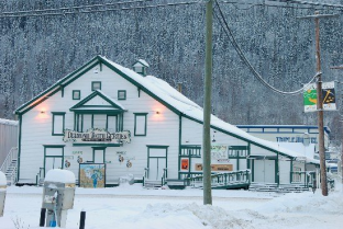
-Dawson City’s world famous non-profit gambling hall is named after bona fide dance hall queen Diamond Tooth Gertie. During the Gold Rush of 1898, in order to distinguish herself from numerous Klondike kings and queens, Gertie Lovejoy wedged a sparkling diamond between her two front teeth. Any discomfort this caused paid dividends. Instead of working the creeks for her riches, Diamond Tooth Gertie made her fortune by mining the lonely prospectors who readily opened their gold pokes in return for her affections. In Dawson City today, Gertrude Lovejoy’s moniker lives on at the town-run Diamond Tooth Gertie's Casino.Replete with cancan dancers and a singing master of ceremonies named Gertie, Canada’s oldest gambling hall gives you a chance to re-live the heady days of Dawson’s Gold Rush era. With three nightly shows by Gertie and her Gertie Girls, Diamond Tooth Gertie's is today a fixture of fun-filled entertainment where patrons can enjoy a beverage while playing blackjack, roulette, Texas Hold'em poker and an array of glittering slot machines.
-Location: Queen and Fourth Ave, Dawson City, Yukon Y0B 1G0 Canada
3.George Black Ferry
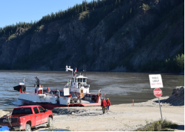
-The George Black ferry is part of the Yukon Highways and Public Works Dept. and it is a free service to travelers. The ferry transports fuel trucks and other commercial vehicles, RVs, passenger vehicles and motorcyclists to/from the Top of the World Highway. It is a drive-on/drive-off single deck ferry. It will be your turn to board when you receive direct visual instructions from the ferry crew that you should move forward.
-The ferry operates 24-hours a day in summer. Peak traffic hours for westbound motorists on the Dawson City side are 7–11 A.M., when you may experience up to a 3-hour delay. Peak hours (and delays) for eastbound motorists on the west side of the river are 2–7 P.M.
-Phone 867-993-5566
VI.History
-In prehistoric times the area was used for agriculture by the Hän-speaking people of the Tr’ondëk Hwëch’in and their forebears. The heart of their homeland was Tr'ochëk, a fishing camp at the confluence of the Klondike River and Yukon River, now a National Historic Site of Canada, just across the Klondike River from modern Dawson City. This site was also an important summer gathering spot and a base for moose-hunting on the Klondike Valley.
-The current settlement was founded by Joseph Ladue and named in January 1897 after noted Canadian geologist George M. Dawson, who had explored and mapped the region in 1887. It served as Yukon's capital from the territory's founding in 1898 until 1952, when the seat was moved to Whitehorse.
-Dawson City was the centre of the Klondike Gold Rush.It began in 1896 and changed the First Nations camp into a thriving city of 40,000 by 1898. By 1899, the gold rush had ended and the town's population plummeted as all but 8,000 people left. When Dawson was incorporated as a city in 1902, the population was under 5,000. St. Paul's Anglican Church, also built that same year, is a National Historic Site.
-The population dropped after World War II when the Alaska Highway bypassed it 300 miles (480 km) to the south. The economic damage to Dawson City was such that Whitehorse, the highway's hub, replaced it as territorial capital in 1953.Dawson City's population languished around the 600–900 mark through the 1960s and 1970s, but has risen and held stable since then. The high price of gold has made modern placer mining operations profitable, and the growth of the tourism industry has encouraged development of facilities. In the early 1950s, Dawson was linked by road to Alaska, and in fall 1955, with Whitehorse along a road that now forms part of the Klondike Highway.
-In 1978, another kind of buried treasure was discovered when a construction excavation inadvertently uncovered a forgotten collection of more than 500 discarded films on highly flammable nitrate film stock from the early 20th century that were buried in (and preserved by) the permafrost. These silent-era film reels, dating from "between 1903 and 1929, were uncovered in the rubble beneath old hockey rink". (See Dawson Film Find.) Owing to its dangerous chemical volatility, the historical find was moved by military transport to Library and Archives Canada and the U.S. Library of Congress for both transfer to safety film and storage. A documentary about the find, Dawson City: Frozen Time was released in 2016.
-The City of Dawson and the nearby ghost town of Forty Mile are featured prominently in the novels and short stories of American author Jack London, including The Call of the Wild. London lived in the Dawson area from October 1897 to June 1898. Other writers who lived in and wrote of Dawson City include Pierre Berton and the poet Robert Service. The childhood home of the former is now used as a retreat for professional writers administered by the Writers' Trust of Canada.
VII.Other information
-The Tr’ondëk Hwëch
•The Tr’ondëk Hwëch’in are a Yukon First Nation based in Dawson City. The citizenship of roughly 1,100 includes descendants of the Hän-speaking people, who have lived along the Yukon River for millennia, and a diverse mix of families descended from Gwich’in, Northern Tutchone and other language groups.
•Yukon First Nations set the land-claims process in motion during the 1970s. Tr’ondëk Hwëch’in began negotiating their individual land claim in 1991. The Tr’ondëk Hwëch’in Final Agreement was signed on July 16, 1998, and came into effect on September 15, 1998.
•The Tr’ondëk Hwëch’in government ensures a strong and healthy future for citizens while maintaining connections to traditional knowledge and the land. The First Nation is governed by an elected Chief and four councillors, who rely on direction from the Elders’ Council, a body comprising all Tr’ondëk Hwëch’in people aged 55 and over. The General Assembly—all voting-age citizens—gather at least once a year to pass extraordinary resolutions, approve legislation and provide direction to political leaders.
VIII.Contact information
-Mayor: Wayne Potoroka
-May – September
•TEL number: 1-867-993-5566
-October – April
•TEL number: 1-867-993-5575
-Toll Free: 1-877-465-3006
-Email: kva@dawson.net
-Website: www.cityofdawson.ca
