Peace River, Alberta 作者: 来源: 发布时间:2021-07-21
I.Population and Area
₋Area
Land: 26.26 km2 (10.14 sq mi)
₋Population (2016)
Total: 6,842
Density: 260.6/km2 (675/sq mi)

II.Natural Geography
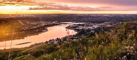
₋Peace River, originally named Peace River Crossing, and known as Rivière-la-Paix in French, is a town in northwestern Alberta, Canada, situated along the banks of the Peace River, at its confluence with the Smoky River, the Heart River and Pat's Creek. It is located 486 kilometres (302 mi) northwest of Edmonton, and 198 kilometres (123 mi) northeast of Grande Prairie, along Highway 2. It was known as the Village of Peace River Crossing between 1914 and 1916.
₋The Peace River townsite is nearly 1,000 feet (300 m) below the relatively flat terrain surrounding it. Pat's Creek used to be an open channel through the town but is now channelled through a culvert under the town streets, re-emerging at the mouth on the Peace River at the Riverfront Park.
₋The population in the Town of Peace River was 6,729 in 2011, a 6.6% increas e over its 2006 population. There are significant nodal settlements and subdivisions in the vicinity of the town on acreages along Highway 2 to the west, Highways 684 (Shaftesbury Trail) and 743 as well as the southwest portion of Northern Sunrise County. Regionally, there are various First Nation communities to the northeast, French-Canadian farming communities to the south and to the east, and Mennonite and Hutterite German-Canadian farming communities to the north and northwest of the town.
₋Peace River was the site of the 2004 Alberta Winter Games. In 2010, Peace River, in conjunction with Grimshaw and surrounding municipalities, jointly hosted the 2010 Alberta Summer Games.

III.Economy
₋The average salary in Peace River, Alberta is C$25.07. Trends in wages decreased by -100.0 percent in Q1 2020. The cost of living in Peace River, Alberta is 100 percent higher than the national average. The most popular occupations in Peace River, Alberta are Administrative Assistant, Electrician, and Registered Nurse (RN) which pay between C$14.88 and C$44.97 per year. The most popular employers in Peace River, Alberta are Alberta Health Services and Nova Hotels.
₋Website: https://www.payscale.com/research/CA/Location=Peace-River-Alberta/Salary
IV.Industrial Characteristics
₋Economy
₋While the Government of Alberta is the largest employer in the town, with over 15 government departments located within its municipal boundaries, it is followed in close second by resource extraction, principally forestry, agriculture, oil and gas and their support services. Over the years, Peace River's economy has expanded to include professional services, manufacturing, health/social services and construction. Major construction companies in the Town of Peace River include Ruel Bros. Contracting, T.H. Gust Builders Ltd. and Glen Armstrong Construction. LaPrairie Works is based in nearby Grimshaw. Among the larger heating and air conditioning contracting companies located in the Town of Peace River is Peace River Heating (1971) Ltd.
₋Many major Canadian financial institutions now have offices in the Town of Peace River. Horizon Credit Union, a Peace Country credit union, is based out of Peace River and recently completed its new head office building on Main Street Peace River.
₋The Town of Peace River sits in the proximity of Peace River Oil Sands, Alberta's 3rd largest oil sands deposit. In May 2010, Penn West Energy Trust signed a $1.25-billion deal with China Investment Corporation to finance operations in the Peace River oil sands area in anticipation of significantly ramping up its production. As part of the deal, $817 million took 45% stake in the oil sands operations and $435 million took 5% equity stake in the trust itself. In January 2010, Shell submitted a regulatory application for an 80,000 barrel-per-day expansion.
₋The Peace River is the largest river in Alberta and yet has the least water allocation licenses. Only 0.2% of provincial water allocations and only 0.3% or 9.1 million cubic metres of all estimated water use in the province are in the Lower Peace Region, implying that less than 1% of the average annual flow is allocated or used. It is for this reason that large energy projects are being considered in the region. In March 2008, Bruce Power made an application with the Canadian Nuclear Safety Commission to build a 4 GW nuclear power plant in the area 30 kilometres west of the Town of Peace River around Lac Cardinal. After a detailed review of that site and other potential sites, Bruce Power Alberta, a subsidiary of Bruce Power announced that it has selected a different site approximately 30 kilometres north of the Town of Peace River. As of December 12, 2011 Bruce Power announced that it would no longer proceed with a nuclear power option in Alberta stating that: “We’ve decided the new nuclear option in Alberta is not something our company will be progressing further.”
V.Attractions
1.Heart River

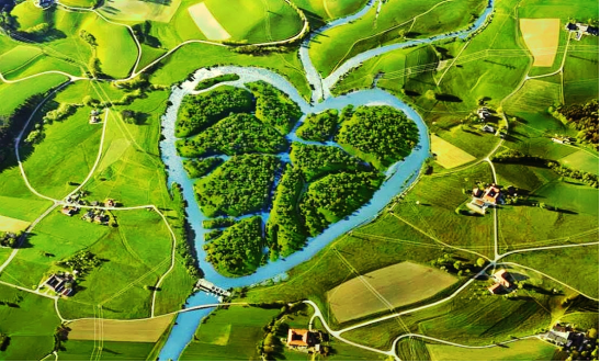
₋The Heart River is a river in northern Alberta, Canada. It is a major tributary of the Peace River.
₋The motto of the village of Nampa, Alberta is A Place close to the Heart, a reference to the river flowing through the community.
₋The Heart River originates in Northern Sunrise County in Alberta, at an elevation of 745 meters (2,444 ft). It flows north through an unnamed lake, then turns westwards as it heads through Harmon Valley Park. It receives the waters from the Harmon Valley Creek as it passes by the settlement of Harmon Valley, then turns south. Up until this point, it is the North Heart River as differentiated from the South Heart River. It receives the waters of Bearhead Creek (also carrying waters from the Benjamin Creek from the east), then turns again westward. It is paralleled by the Mackenzie Northern Railway as it passes by the hamlet of Reno and through the village of Nampa. Heart River then receives Myrtle Creek, which is flowing north just east of the village of Nampa. It is crossed by Highway 2, then continues westwards by the hamlet of Marie-Reine, then turns north and flows through a 150 meters (490 ft) deep canyon through the Greene Valley Provincial Park. It then empties in the Peace River, immediately downstream from the Smoky River mouth, at an elevation of 320 meters (1,050 ft), within the Peace River town limits.
₋Heart River drains an area of approximately 1,900 km2 (730 sq mi). The watershed can be categorized into three major sub-basins: the North Heart River whose drainage area is about 830 km2; Bearhead Creek including Benjamin Creek whose drainage area is about 773 km2 and Myrtle Creek including the Nampa South Drainage Project whose drainage area is 201 km2.
₋Website: https://www.albertaparks.ca/parks/northwest/heart-river-dam-pra/
2.Normand Boucher Arboretum

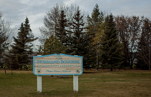
₋Originally a landfill site in the 1970’s, the Normand Boucher Arboretum is the result of over 25 years of hard work and dedication. Opened in 1990 to help celebrate Peace River’s designation as Canada’s foresty capital, at the time the Arboretum had only 18 species of plant and trees since then it has grown thanks to the work of local residents. The addition of park benches, a gazebo and an irrigation system has helped it to grown into one of the North-ends best loved parks. On the occasion of the 50th anniversary of Boucher Bros. Lumber – Nampa, in 2001, we were pleased to have this site re-named to show them our appreciation of their contributions.
₋The Normand Boucher Community Arboretum is a truly special “living” community asset.
₋Website: https://peaceriver.ca/community-directory/normand-boucher-arboretum/
3.Ski resort Misery Mountain

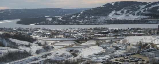
₋The ski resort Misery Mountain is located in Northern Alberta (Canada, Alberta). For skiing and snowboarding, there are 8 km of slopes available. 3 lifts transport the guests. The winter sports area is situated between the elevations of 337 and 484 m.
₋Website: https://www.skiresort.info/ski-resort/misery-mountain/
VI.History
₋After the last glacial ice sheets melted from the northern parts of the Canadian prairies, an ice-free corridor allowed people from Asia to make a way deep into the Americas. When the Ice Age ended, many of these groups moved back north following the large herds of grazing animals which were, in turn, following the grasses northward in the warming climate. In the Peace River area, the two major language groups were the Athapaskan and the Algonquian.
₋In 1670, following the arrival of the Hudson's Bay Company in Eastern Canada, guns began making their way westward as trade goods and the Algonquian speaking Cree began pushing the Athapaskan speakers Dunne-za or Beaver further west. The Beaver in turn pushed the Sekani deep into the Rocky Mountain Trench in the mid-18th century. A truce was eventually agreed to by the Cree and the Beaver and the great river they called Unchagah (the Peace River) became the boundary between their hunting territories.\
₋The North West Company pushed westward in the late 18th century in an attempt to reach the Pacific Ocean, creating rivalry with the other major fur-trading company, the Hudson's Bay Company.
₋Timeline
1792: Alexander MacKenzie established Fort Fork on the eastern bank of Peace River just south of its confluence with the Smoky River.
1818, the HBC opens the first Fort St. Mary's at the forks of the Peace and the Smoky, it lasted for only one season
1820, the HBC built Fort St. Mary's III on the west side of the Peace River, directly across from the mouth of the Heart River (in the present day Town of Peace River). This was the third and final relocation of Fort St. Mary's
1886: The Anglican Church sets up the first mission on Shaftesbury Trail.
1888: The Roman Catholic Church sets up St. Augustine mission on Shaftesbury Trail.
1898: The North-West Mounted Police make a permanent post at Peace River Crossing.
1909: The townsite of Peace River is first surveyed.
1914: Peace River Landing Settlement is incorporated as the Village of Peace River Crossing on June 2.
1914: Peace River's first hospital, the Irene Cottage Hospital, opens
1910-1916: Railway reaches the area and settlers begin colonizing the valley.
1916: Village of Peace River Crossing is renamed the Village of Peace River on May 22.
1919: Village of Peace River is incorporated as the Town of Peace River on December 1.
1926-1931: The population continues to grow as the Great Depression took hold of Saskatchewan and Southern Alberta
₋Historical sites and architecture
₋The Northern Alberta Railway (NAR) station was built in 1916 by the Central Canada Railway. It served as a major hub of activity from 1916 to 1956 for passengers. The station was continued for use for freight and the station was closed in 1981. The NAR station suffered a fire in 1986. It was restored back to its former state in 1991, costing nearly $300,000 to complete. It currently houses the Peace River & District Chamber of Commerce and the Tourist Information Centre in Peace River. It is located on 94 Avenue block of 100 Street next to the railway tracks that cross through Peace River.
₋The NAR station was used again as a railway station for first time in about 30 years by passengers when the Alberta Prairie Steam Tours, owners of the passenger cars, sent eight coaches to Peace River in September 2006, thereby enabling riders to travel like the pioneers of the area did in the 1920s. It involved short trips to DMI, a pulp mill 20 kilometres north of the Town of Peace River, and to Grimshaw. The train ride also included on-board entertainment.
₋The Catholic St. Augustine Mission located along Shaftesbury Trail on River Lot 22 was established in 1888 when the missionaries first came to the Peace country to evangelize and educate the First Nations people. Alongside the mission is an old cemetery. This site is located within the Peace River Provincial Correctional Centre which was built in 1968.
₋Third Mission Heritage Suites located at 100 Avenue block of 98 Street adjacent to Riverfront Park and across from the original Hudson's Bay Factor's House (1904). was formerly the priests’ house that was moved by CAT over the ice to Peace River in 1958 and functioned as residential apartments before being renovated into a hotel suite.
₋Anglican Mission Site was established on River Lot 11 on Shaftesbury Trail in 1886, all that remains now is a small cemetery.
₋The St. James Anglican Cathedral Church was built in 1936. The parish also erected Athabasca Hall around the same time adjacent to it. With the Athabasca Hall being the largest facility in town at that time, the hall bookings became too much for the parish decided to lease it to the Peace River Recreation Board in 1972 for 20 years. In 1979, the parish's first dean emeritus sold it to the Town of Peace River and used the proceeds to add a new church hall connected to the cathedral.
₋The McNamara Hotel was built in 1921 by Martin Joseph McNamara. It has burnt down twice in the past; once in 1926 and 1993, and rebuilt both times.
₋Fort Fork site, located in the Peace River Wildland Provincial Park is a national historic site. The fort was erected in 1792 by the North West Company. Alexander Mackenzie wintered at Fort Fork in 1792 as did David Thompson in 1802. The fort was abandoned in 1805 and has since been almost completed eroded by the Peace River. A flag planted at Fort Fork's former site is all that remains. Mackenzie Cairn was erected on River Lot 19 in the Municipal District (M.D.) of Peace No. 135 in 1929 to commemorate Fort Fork.
₋A 12-foot-tall (3.7 m) wooden statue stands at the Riverfront Park in Peace River to commemorate Henry Fuller Davis, one of the most famous figures in the Town of Peace River's history. His “Twelve-Foot Davis” nickname stems from the 12-foot land claim during the Cariboo Country gold rush in British Columbia which netted him almost $30,000 worth of gold. He took these profits and staked it all on a trading post close to where the Town of Peace River stands today. It is for this reason that the Town of Peace River is sometimes referred to as the Land of Twelve-Foot Davis. Twelve-Foot Davis' gravesite is designated a park and is located on the top of Grouard Hill just east of the town.
₋Dr. Greene Cairn located in Greene Valley Provincial Park is a historical fixture that remembers Dr. William Greene for his contributions to the community and to the organizations to which he belonged to. Born and raised in San Francisco, Dr. Greene was a medical doctor and dentist in addition to being among first eight men to fly, according to a 1910 edition of New York Sun.
₋Legends
An ancient Beaver Indian legend says: "Drink the water of the Peace River and you will return."
VII.Other Information
₋Infrastructure
₋Transportation
₋The Town of Peace River is located on Highway 2 to southern Alberta and near Highways 35 to Northwest Territories, and Highway 43 to British Columbia and Alaska thereby making it an important ground link to these destinations. These highways also provide access to the rich oil and gas fields and forests.
₋What was formerly the Northern Alberta Railway tracks through the town provide the only rail crossing over the Peace River in Alberta. The Canadian government built the Great Slave Lake Railway which started at Roma, a few kilometres west of the Town of Peace River on the Northern Alberta Railways and ran north to the southern shores of Great Slave Lake at Hay River, Northwest Territories. It is Canada's most northern railroad. The federal government's intent was to ease shipment of lead-zinc ore from the Pine Point Mines southwest of the lake. Currently Canadian National Railway owns and operates the line.
₋Road network
₋The road system in Peace River is on a grid where roads are numbered with avenues run east to west and streets run north to south. Postfix letter "A" is added to the name numbers of street that do not conform to the grid, lying between two streets that conform. With 100 Avenue and 100 Street located in the downtown core, the avenue numbers increase southwards and street numbers decrease eastwards. Some roads still bear the historical street names assigned in the pioneering days, in addition to the modern road numbering nomenclature, especially in the downtown area.
₋Airport
₋The town owns and manages a municipal airport, the Peace River Airport (IATA: YPE, ICAO: CYPE) located 5 kilometre west on Highway 2. Northern Air has regular flights from it to and from Edmonton International Airport Monday through Friday. They also charter flights from Peace River Airport as well as air ambulance. Peace Air once headquartered at the airport ceased operations in 2007.
₋The Peace River Airport Steering Committee has been set up to assess viability and regionalization potential the airport. The committee has representatives from the Town of Peace River, Northern Sunrise County, M.D. of Peace No. 135, County of Northern Lights and the Town of Grimshaw, and is working on a business plan.
₋Public transit
₋The town's Community Services Department managed the Peace River Transit, a small bus network operated by the Bus Company. The 2006 Census indicated that 1.4% of people in the Peace River used public transit to go to work, while 7.3% chose to walk or bike to work (the provincial averages are 9.2% and 7.1% respectively). According to the Peace River Transit Pilot Project Survey, 38% of the lower income earners used Peace River Transit. Statistics from Community Services Department indicated that the ridership had been on a steady climb since its inception in 2005. By June 2010, the number of rides provided for that month was almost 80% of the total rides provided in the entire year of 2005. Because the transit buses were not wheelchair accessible, special taxi passes were also made available at a discounted rate to seniors, mentally/physically challenged persons, low income individuals/families and students at Northern Lakes College through the Community Services Department. Peace River's transit system was discontinued in early 2011, due in part to high operating costs. However, the taxi pass program is still available to eligible individuals.
₋Among the bigger challenges facing the town (and other small towns) with respect to mass transit is the low overall population density and dispersed development that results in a pattern of travel that is less focused on the downtown and hence more difficult to serve by transit. Studies show that for every 1% increase in residential density, there is a 0.22% rise in transit ridership. However, destination density, such as clustered employment locations, tend to have a larger impact on transit ridership than residential density alone.
₋Utilities
₋The Town of Peace River extracts water from the Peace River at the Shaftesbury Water Treatment Plant. The treatment process involves clarification, sedimentation, filtration, chlorination and fluoridation. The potable water is then pumped to the three reservoirs the town owns. Sanitary waste is piped to the wastewater treatment plant in the north end of town that involves secondary treatment and extended aeration. Residential garbage pickup is contracted out to Allen Bros. Trucking Ltd., a private company.
₋The Town of Peace River provides municipal sanitary sewer and treated potable water against a unique set of topographical and climatic conditions. There is a significant annual variation in temperature compounded by dramatic changes in elevation within town that leads to frequent leaks and breaks in water mains and sewer trunks. The dramatic changes in elevation also necessitate a large number of lift stations to pump both treated drinking water and sewage across large distances. When combined with the maintenance issues associated with the unstable soils, these factors lead to very high infrastructure costs for urban development within the valley.
₋Health care
₋The Peace River area is served by the Peace River Community Health Centre, which is a site for Rural Alberta North & Rural Family Medical Training Program for University of Alberta. Other hospitals in the area include the Grimshaw/Berwyn Community Health Complex in Grimshaw, the Manning Community Health Centre in Manning and the Sacred Heart Community Health Centre in McLennan. Peace River Mental Health Clinic in downtown Peace River provides psychiatric care for patients in the region. When very specialized care is required, patients are often transferred to Edmonton via air ambulance. Initially under Peace Country Health Services, these hospitals are now administered by Alberta Health Services.
₋Drop-in health needs are catered for at the Associate Medical Clinic in downtown Peace River. The clinic is working on plans for a new state-of-the-art medical clinic, Centre of Medical Excellence to be located adjacent to the Peace River Community Health Centre in West Hill. The over 42,000-square-foot (3,900 m2) facility is intended to increase both the capacity and the efficiency of medical care in the region. Conceptual plans are located at Associate Medical Clinic website.
₋There is a handful of pharmacies, dental offices, chiropractic clinics and optometrists in town.
VIII.Contact Information
₋Government
Mayor: Tom Tarpey
Governing body Peace: River Town Council
₋City Hall
₋Town Administrative Office Hours:
Mon - Thur: 9:00 AM - 4:30 PM
Fri: 9:30 AM - 4:30 PM
Closed Holidays
₋Address:
9911 - 100 Street
P.O. Box 6600
Peace River, Alberta
T8S 1S4
