Longueuil, Quebec 作者: 来源: 发布时间:2021-07-21
I.Population and Area
₋Area
Land: 122.90 km2 (47.45 sq mi)
₋Population (2016)
Total: 239,300
Density: 2,002.0/km2 (5,185/sq mi)

II.Natural Geography
₋Longueuil (/lɒŋˈɡeɪl/; French: [lɔ̃ɡœj]) is a city in the province of Quebec, Canada. It is the seat of the Montérégie administrative region and the central city of the urban agglomeration of Longueuil. It sits on the south shore of the Saint Lawrence River directly across from Montreal. The population as of the Canada 2016 Census totalled 239,700, making it Montreal's second largest suburb, the fifth most populous city in Quebec and twentieth largest in Canada.
₋Charles Le Moyne founded Longueuil as a seigneurie in 1657. It would become a parish in 1845, a village in 1848, a town in 1874 and a city in 1920. Between 1961 and 2002, Longueuil's borders grew three times, as it was amalgamated with surrounding municipalities; there was a strong de-amalgamation in 2006 (see 2000–2006 municipal reorganization in Quebec).
₋Longueuil is a residential, commercial and industrial city. It incorporates some urban features, but is essentially a suburb. Longueuil can be classified as a commuter town as a large portion of its residents commute to work in Montreal. Most buildings are single-family homes constructed in the post-war period. The city consists of three boroughs: Le Vieux-Longueuil, Saint-Hubert and Greenfield Park.
₋Longueuil is the seat of the judicial district of Longueuil. Residents of the city are called Longueuillois.
₋Longueuil occupies 115.59 square kilometres (44.6 sq mi) of land. The city is bordered by the cities of Saint-Lambert and Brossard to the west, Boucherville and Saint-Bruno-de-Montarville to the east, and the Saint Lawrence River and Montreal to the north. The city of Longueuil is located approximately 7 kilometres (5 mi) south of Montreal on the south shore of the Saint Lawrence River.
₋Longueuil is located in the Saint Lawrence River valley, and is a vast plain. Areas near the river were originally swamp land with mixed forest, and later p rime agricultural land. Agricultural land still exists in the portions of the city furthest from the river.
₋The city of Longueuil also includes Île Charron, a small island in the Saint Lawrence River, and part of the Boucherville Islands.
₋Like Montreal, Longueuil is classified as humid continental or hemiboreal (Köppen climate classification Dfb). Longueuil has long winters, lasting from November to March, short springs during April and May, average summers, lasting from June to August, and short autumns during September and October.

III.Economy
₋Average Ville de Longueuil hourly pay ranges from approximately $19.66 per hour for Administrator to $42.32 per hour for Conseiller(ère) en Sécurité Financière. The average Ville de Longueuil salary ranges from approximately $57,723 per year for Secrétaire-réceptionniste to $149,796 per year for Directeur(trice).
₋Website: https://ca.indeed.com/cmp/Ville-De-Longueuil/salaries#:~:text=Average%20Ville%20de%20Longueuil%20hourly,year%20for%20Directeur(trice).
IV.Industrial Characteristics
₋Economic activities:
15 industrial zones and parks
2,025 businesses employing 62,507 workers
45% are manufacturing companies
30% export goods
201 subsidiaries of multinational corporations employing 14,494 workers
Economy: $16.1 billion
Exports: $4.7 billion
80% of the businesses in the Agglomération de Longueuil that export do so to the United States
₋Agri-food
Companies in the region (PDF, 396 KB)
At the crossroads of a full-frowth industry5
170 companies
7,500 jobs
All links of the production chain are represented // 33% of the agricultural land base, processing, distribution and supply companies
₋Website: https://www.longueuil.quebec/en/economic
V.Attractions
1.Îles-de-Boucherville National Park

₋Îles-de-Boucherville National Park is a provincial park of the province of Quebec. It is administered by Sépaq, the Société des établissements de plein air du Québec, which manages several Quebec parks and wildlife refuges. All provincial parks in Quebec have used the term "national park" since 2002, but there is no connection to the federal national park system, administered by Parks Canada.
₋Address: 55 Île Sainte Marguerite, Boucherville, QC J4B 5J6
₋Phone: (450) 928-5088
₋Website: https://www.sepaq.com/pq/bou/index.dot?language_id=1
2.Mont-Saint-Bruno National Park

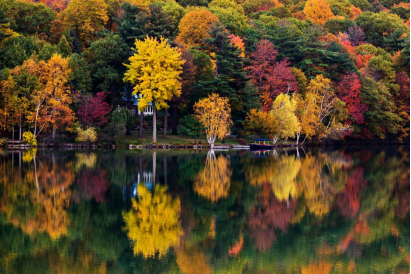
₋Mont-Saint-Bruno National Park (French: Parc National du Mont-Saint-Bruno) is a small national park of Quebec located near the municipality of Saint-Bruno-de-Montarville, 15 kilometres (9.3 mi) to the east of Montréal on the south shore of the Saint Lawrence River. The park, with an area of 8.84 square kilometres (3.41 sq mi), notably includes the Mount Saint-Bruno, one of the Monteregian Hills which peaks at 218 metres (715 ft). The mountain is shared with the Ski Mont Saint-Bruno ski resort, a quarry and a small Canadian Forces (5th GSS) training camp. Despite its relatively small size, the mountain is known for its rich fauna and flora. Situated at the heart of the old signory of Montarville , its many lakes have permitted the construction and exploitation of many water mills, contributing to the region's economical success. A building from one of those mills, the "Vieux Moulin" (Old Mill), still stands to this day and is used as a rest area for skiers and hikers in different seasons.
₋At the beginning of the 20th century, the mountain became a luxury resort and a sought-after area for the food needs of various religious communities. One of those communities, the Brothers of Christian Instruction of St Gabriel, went as far as building a school and an arboretum for the benefit of the neighboring population. In 1976, the Government of Quebec acquired part of the mountain. It established a park in 1985 that, since 1999, is managed by the Société des établissements de plein air du Québec (SÉPAQ).
₋The park sees approximately 750,000 visitors yearly, where hiking, cross-country skiing and alpine skiing are amongst the most popular activities enjoyed.
₋Address: 330 Rang des Vingt Cinq E, Saint-Bruno-de-Montarville, QC J3V 4P6
₋Phone: (450) 653-7544\
₋Website: https://www.sepaq.com/pq/msb/index.dot?language_id=1
3.Co-Cathedral of Saint-Antoine-de-Padoue

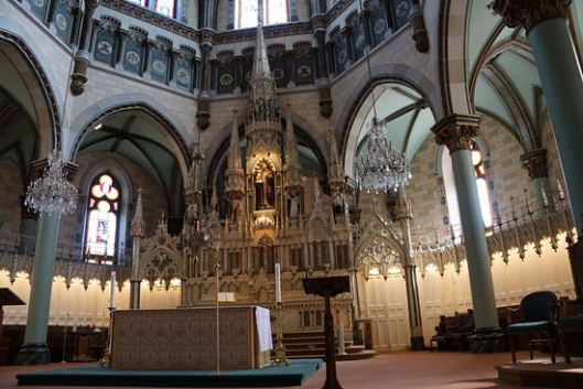
₋The Co-Cathedral of Saint-Antoine-de-Padoue (French: Co-cathédrale Saint-Antoine-de-Padoue) is a co-cathedral in Longueuil, Quebec, Canada, on Montreal's south shore. It is located on the corner of Rue Saint-Charles and Chemin Chambly in the Borough of Le Vieux-Longueuil. It is dedicated to St. Anthony of Padua. The cathedral houses the remains of the Blessed Marie-Rose Durocher, the foundress of the Sisters of the Holy Names of Jesus and Mary.
₋Its episcopal region is Longueuil-Nord. Lionel Gendron, the bishop, has a cathedra sculpted in walnut. Before the reign of Bernard Hubert, it was simply a parish church.
₋The cathedral was classified as historical monument by the Government of Quebec in 1984.
₋The site contains the archaeological remains of Fort Longueuil, a fort constructed between 1685 and 1690 as the fortified residence of Charles le Moyne de Longueuil, the only Canadian-born person to be raised to the rank of Baron by the French King. The fort was demolished in 1810 and the cathedral contains stone building materials and elements salvaged from the fort. The site of the fort was designated a National Historic Site of Canada in 1923.
₋The Parish of Saint-Antoine-de-Padoue was founded in 1698, and is one of the oldest in Canada. The present cathedral building was largely built from 1884 to 1887, although it was not completed until 1911. It is the third church in the history of Longueuil, the first being completed in 1811.
₋Saint-Antoine-de-Padoue was designated as a co-cathedral in 1982 when the Roman Catholic Diocese of Saint-Jean-de-Québec was renamed the Roman Catholic Diocese of Saint-Jean-Longueuil. The Cathedral of Saint-Jean-l'Évangéliste has been the primary cathedral of the diocese since its establishment in 1933.
₋A funeral was held for Jean-Pierre Côté, the 23rd Lieutenant Governor of Quebec, on July 17, 2002.
₋In 2005, that the faithful of the diocese paid tribute to Pope John Paul II, following his death. They also wished a happy pontificate to his successor, Pope Benedict XVI, during a special vigil attended by the bishop as well as a local congregation of Filipino Religious Sisters.
₋Address: 55 Rue Sainte Élizabeth, Longueuil, QC J4H 1J3
₋Phone: (450) 674-1549
₋Website: https://www.cocathedrale.ca/
VI.History
₋The territory of New France was divided into seigneuries in order to ensure the colony's defence. Longueuil was founded in 1657 by Charles Le Moyne, a merchant from Ville-Marie (present day Montreal), as a seigneurie. According to Abbé Faillon, Charles Le Moyne, lord of the area starting in 1657, named Longueuil after a village which is today the seat of a canton in the district of Dieppe in his homeland of Normandy.
₋His son, Charles Le Moyne de Longueuil, built Fort Longueuil as his fortified residence. It was constructed of stone between 1685 and 1690 and had four towers.
₋Fort Longueuil was believed to be occupied by American troops during the American Revolutionary War. It was subsequently occupied by the British. It was demolished in 1810 due to its poor condition. The archaeological remains of Fort Longueuil were recognized as a National Historic Site of Canada on May 25, 1923. The site extends beneath the present-day Saint-Antoine-de-Padoue Cathedral.
₋The seigneurial system ended in 1845 and Longueuil was turned into a parish municipality named Saint-Antoine-de-Longueuil. In 1848, a portion detached from the parish and officially established as the village of Longueuil. This same village became a town in 1874, and then a city in 1920. Musician Paul Pratt notably served as the city's mayor from 1935–1966.
₋Longueuil's city limits expanded for the first time in 1961 when it merged with Montréal-Sud, and again in 1969 when it merged with Ville Jacques-Cartier. In both cases, Longueuil was chosen as the name of the new city.
₋On January 1, 2002, as part of the 2000–2006 municipal reorganization in Quebec, the provincial government amalgamated the former Longueuil with Boucherville, Brossard, Greenfield Park, LeMoyne, Saint-Bruno-de-Montarville, Saint-Hubert and Saint-Lambert. As with the 1960s, the name Longueuil was chosen for the new city. However, after a change of government and a 2004 referendum, Boucherville, Brossard, Saint-Lambert and Saint-Bruno-de-Montarville were re-constituted as independent cities on January 1, 2006. As such, the current city of Longueuil now includes only the former cities of Longueuil (1969-2002), Saint-Hubert, Greenfield Park and LeMoyne.
VII.Other Information
₋Infrastructure
₋Commuting patterns
According to the 2006 Census, about 39,485 city residents (17.2% of the total population) commute to work in Montreal on a daily basis, while only 38,090 residents (16.6%) work in the city itself. A further 6,915 residents (3.0%) work in Boucherville every day, 4,775 (2.1%) work in Brossard, 2,795 (1.2%) in Saint-Bruno-de-Montarville, and 1,815 (0.8%) work in Saint-Lambert, the four other constituent cities of the Longueuil agglomeration.
By contrast only 8,845 people commute from Montreal to work in Longueuil every day, while 4,080 people commute from Brossard to work in Longueuil, 2,940 people commute from Boucherville, 2,090 from Sainte-Julie, 1,825 from Saint-Bruno-de-Montarville, 1,815 from Chambly, and 1,810 from Saint-Jean-sur-Richelieu.
₋Roads
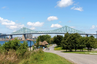
The Saint Lawrence River between the Island of Montreal and the south shore is traversed by only five automobile crossings. Two of these are in Longueuil, the Louis Hippolyte Lafontaine Tunnel (part of Autoroute 25) and the Jacques Cartier Bridge (part of Route 134).
Autoroute 20 is an important highway in Longueuil, bordering the Saint Lawrence River in the Le Vieux-Longueuil borough, where it co-exists with Autoroute René-Lévesque (Route 132), and finally heading eastward toward Boucherville. Autoroute 30 crosses the Saint-Hubert borough in the southern part of the city, between the cities of Brossard and Saint-Bruno-de-Montarville.
Route 116 is another major highway, with its western terminus located in LeMoyne, heading east through the borough of Saint-Hubert toward Saint-Bruno-de-Montarville. Route 112 co-exists with Route 116 from LeMoyne to Cousineau Boulevard in Saint-Hubert, where it heads southeast toward Carignan. Route 134 is a major artery, perhaps better known by its more common names: the Jacques Cartier Bridge on the portion crossing the Saint-Lawrence River, and Taschereau Boulevard which connects the bridge to all three boroughs of Longueuil, and southward toward the city of Brossard.
₋Public transportation
The Réseau de transport de Longueuil (RTL) provides bus service in Longueuil. There are 77 bus routes and 12 shared taxi routes serving 139,374 passengers per day, and 32,738,155 passengers in 2011. Almost all bus lines of the RTL terminate at the Longueuil Bus Terminus. Many buses terminating at the other main bus terminus, Brossard-Panama, cross the Champlain Bridge to arrive at the Terminus Centre-Ville in downtown Montreal (under the 1000 de la Gauchetière office tower, at Bonaventure Metro).
The city is also served by the Longueuil–Université-de-Sherbrooke Metro station, adjacent to the Longueuil bus terminus. The station connects to downtown Montreal via the Yellow Line of the Metro. The Réseau de transport métropolitain (RTM) runs the Mont-Saint-Hilaire commuter train line also serves the south shore. The only commuter train station in the city of Longueuil is Longueuil–Saint-Hubert station. Until the mid-1950s, Longueuil was served by interurban streetcars operated by the Montreal and Southern Counties Railway.
Longueuil also has a small airport, Saint-Hubert Airport. It is one of Canada's most important general aviation airports, ranked 12th busiest airport by aircraft movements.
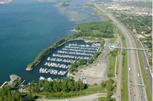
A small marina, the Réal-Bouvier Marina is located on the Saint Lawrence River in the borough of Le Vieux-Longueuil. The Old Port of Montreal–Longueuil Ferry is a seasonal ferry service links the Réal-Bouvier Marina to the Jacques Cartier Pier in the Old Port of Montreal.
₋Hospitals
The city is served by two hospitals. The Charles-LeMoyne Hospital is a Université de Sherbrooke affiliated hospital in the borough of Greenfield Park. It is the main hospital for Longueuil, as well as the neighbouring cities of Saint-Lambert and Brossard. The Pierre-Boucher Hospital is a smaller hospital in the borough of Le Vieux-Longueuil which serves Le Vieux-Longueuil, Boucherville, Varennes, Sainte-Julie, Saint-Amable, Verchères, Calixa-Lavallée and Contrecœur.
VIII.Contact Information
₋Government
Type: Longueuil City Council
Mayor: Sylvie Parent
₋City Hall
₋Address:
4250, chemin de la Savane
Longueuil(Quebec)
J3Y 9G4
Canada
₋Phone:
311
450 463-7311 (from outside Longueuil)
₋Email:
₋Contact us via Mon portail citoyen
