Magog, Quebec 作者: 来源: 发布时间:2021-07-21
I.Population and Area
₋Area
Land: 167.50 km2 (64.67 sq mi)
₋Population (2016)
Total: 25,358
Density: 175.9/km2 (456/sq mi)
II.Natural Geography
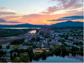
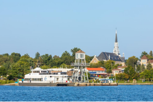
₋Magog (locally /ˈmeɪɡɔːɡ/; [maˈɡɔɡ]) is a city in southeastern Quebec, Canada, about 120 kilometres (75 mi) east of Montreal at the confluence of Lake Memphremagog—after which the city was named—with the Rivière aux Cerises and the Magog River. It is a major centre and industrial city in the Regional County Municipality of Memphremagog. The city lies in the Eastern Townships tourist region.
₋In 2002 the City of Magog was merged with the Township of Magog and the Village of Omerville as part of the municipal reorganization in Quebe c.
₋Magog is a city in southeastern Quebec, Canada, about 120 kilometres (75 mi) east of Montreal at the confluence of Lake Memphremagog, the Rivière aux Cerises, and the Magog River. The city of Magog is also in close proximity, 35km (21.8mi), to the Derby Line–Stanstead border crossing station at the Canada-United States border.
III.Economy
₋The average salary in Magog, Québec is C$21.58. Trends in wages decreased by -100.0 percent in Q1 2020. The cost of living in Magog, Québec is 100 percent higher than the national average.
₋Website: https://www.payscale.com/research/CA/Location=Magog-Qu%C3%A9bec/Salary
IV.Industrial Characteristics
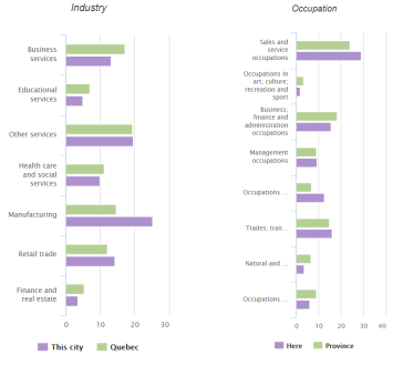
₋Website: http://www.city-data.com/canada/Magog-City.html
V.Attractions
1.Mont-Orford National Park
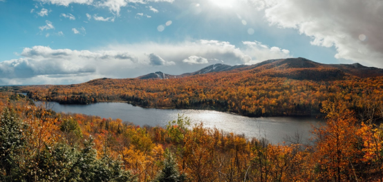
₋Mont-Orford National Park is a national park in Orford, Quebec, Canada that is maintained and protected by the Sépaq. a provincial body.
₋The park is located immediately north of Magog in the Eastern Townships tourist region of the province. It encompasses several mountain peaks, among which are Mont Orford, Mont Giroux (Pic aux Corbeaux), Mont Alfred Desrochers, Mont Chauve, and the Massif des Chênes.
₋The park is open year-round. Popular summer activities in the park include camping, hiking, swimming, cycling, canoeing, kayaking, pedalos, row boating, rock climbing, paddle surfing, and wildlife watching. The most popular winter sport in the park is alpine skiing, with cross-country skiing, snowshoeing, snow walking, and Ski-Vel (wheelchair skiing).
₋Website: https://www.sepaq.com/pq/mor/index.dot?language_id=1
2.Lake Memphremagog
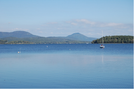
₋Lake Memphremagog (French: Lac Memphrémagog) is a fresh water glacial lake located between Newport, Vermont, United States and Magog, Quebec, Canada. The lake spans both Quebec and Vermont, but is mostly in Quebec. Most of the watershed that feeds the lake is located in Vermont, and is a source for accumulated phosphorus, sediments and other pollutants. Cleanup efforts since the late 1980s have improved the water quality. The lake furnishes potable (drinking) water for 200,000 people.
₋The lake is 31 miles (50 km) long with 73 percent of the lake's surface area in Quebec, where it drains into the Magog River. However, three-quarters of its watershed, 489 square miles (1,270 km2), is in Vermont. The total is 687 square miles (1,780 km2), with 198 square miles (510 km2) located in Quebec. In Vermont, the lake lies in parts of the towns of Derby and Newport, in addition to the City of Newport, all in Orleans County. In Quebec, the lake lies in parts of Austin, Magog, Ogden, Potton, Saint-Benoît-du-Lac, and Stanstead Township, all in Memphrémagog Regional County Municipality. The lake occupies most of what the Vermont Agency of Natural Resources calls "Basin 17". At the very south end of the lake, there is the South Bay, connected by the narrowest part of the lake.
₋The lake elevation is approximately 682 feet (208 m) above mean sea level. Both ends of the lake are fairly shallow, with depth ranges of 20 feet (6.1 m) to 30 feet (9.1 m). The lake bottom takes a dramatic drop in Canada, starting opposite Mont Owl's Head and continuing that way north to Gibraltar Point, where it starts to climb back to the shallows of the north end. Its maximum recorded depth of 351 feet (107 m) is located in Canada, opposite Jewett Point (at approximately 45.111621°N 72.278491°W). The lake is the third deepest in Vermont. It contains 21 islands. Province Island, the largest, is divided by the international border. The lake is irregular in shape, and along its shores are several striking indentations, in some places low, and in some other parts high and rocky. Along the western shore of the lake are several mountains, prominent among which are Owl's Head, Elephantis, and the Hog's Back.
₋Website: https://www.britannica.com/place/Lake-Memphremagog
3.Lake Magog

₋Lake Magog is a freshwater lake located in the Estrie region of Quebec, Canada. It is bordered by three municipalities: Sherbrooke, Magog and Sainte-Catherine-de-Hatley. Loc ated in the Appalachian geological province, Lake Magog consists of sedimentary rock, especially slate and sandstone. Lake Magog is part of the watershed of the St. Francois River, which flows into the St. Lawrence River.
₋The drainage area of the Magog River's watershed is 2,032 square kilometres (785 sq mi). Lake Magog's the maximum length and width are 11.1 kilometres (6.9 mi) and 2.1 kilometres (1.3 mi), respectively. Its area is 10.8 square kilometres (4.2 sq mi). The maximum depth is 18.85 metres (61.8 ft) and its and average depth is 8.65 metres (28.4 ft). Lake Magog's water is supplied mainly by the Magog River which flows from Lake Memphremagog. There are a couple of streams of different sizes that feed the river and Lake Magog.
₋Four hydroelectric dams were built near Lake Magog. Their role is to generate electricity and control the level of water. Magog Lake is a reservoir resulting from these dams, the most influential being that of Rock Forest built in 1911. These dams alter the rate of renewal of the lake by changing the flow of the Magog River.
₋Lake Magog contains eight islands (all private), including two islets, as well as two shoals which have been small islands in the past. Two islands are constructed: the island of the nautical club, and the largest island of the Marinier Archipelago (also known as Odanak Islands). At the southern end of the lake, a 65 hectares (160 acres) marsh is accessible to hikers.
₋Website: https://www.easterntownships.org/things-to-do/4361/lake-memphremagog
VI.History
₋The Abenaki were the first to inhabit the region[citation needed] and had long visited the Memphremagog and its waterways. The town was founded in 1776, when Loyalists emigrated from nearby Vermont. They called it The Outlet, referring to the flow of water emptying into the Magog River from the lake.
₋Considered the founder of Magog, Ralph Merry, an American Revolutionary, immigrated to Lower Canada in 1799 and settled in Bolton, to the west of the lake. He bought up all the neighboring lots, including the village of Magog, where he went on to act as its mayor, judge, and developer. In 1821, he built a house there, which is the oldest standing house in the city.
₋It was formally named Magog in 1855.
₋At the end of the 19th century and throughout the 20th, the city's economy was dominated by the textile industry, most notably by a cotton mill operated by Dominion Textile. It wasn't until the 1960s and 70s that the city's economy would achieve desperately needed diversification via tourism, services, and the development of the industrial park.
₋In 2002 the City of Magog was merged with the Township of Magog and the Village of Omerville as part of the municipal reorganization in Quebec.
VII.Other Information
₋Réjean Hébert, Quebec Minister of Health and Social Services and Minister Responsible for the Estrie region, on behalf of Sylvain Gaudreault, Quebec Minister of Municipal Affairs, Regions and Land Occupancy, Minister of Transport and Member of the National Assembly for Jonquière, and residents of Magog today celebrated the end of work to their drinking water treatment plant. The Honourable Denis Lebel, Minister of Transport, Infrastructure and Communities and Minister of the Economic Development Agency of Canada for the Regions of Quebec, is pleased that this project is completed.
₋"The Government of Canada is proud to have supported these upgrades for Magog residents to continue to receive safe, clean drinking water," said Minister Lebel. "Our infrastructure investments are an important driver of economic growth and job creation in Quebec. I am pleased that this project will support the health of local residents, while contributing to the economic future of the Estrie region."
₋"I am very pleased that this important water infrastructure project came to be in Magog. It will promote health and well-being for residents, as well as tourists who are passing through. The Government of Quebec recognizes the importance of renovating and replacing water facilities in Quebec municipalities, in order to offer quality public services to the population, notably access to drinking water, which is a fundamental right and an essential service for all," declared Minister Hébert.
₋This project, for which the City of Magog received a government contribution of $10,879,288, consisted of the upgrade of the drinking water treatment plant, as well as the upgrade of all of its facilities. The highlights of these improvements include the rehabilitation of the Théroux pumping station, as well as the installation of a continuous filtration and disinfection treatment line in a brand new building at the Des Pins reservoir. Thanks to these improvement, the City of Magog is now in a position to offer better quality drinking water, in addition to respecting the standards set by the province in the Regulation respecting the quality of drinking water (Règlement sur la qualité de l'eau potable). Overall, approximately 16,000 people will benefit from these improvements.
₋Upgrades to the drinking water treatment plant were performed thanks to a contribution of close to $5.9 million, of which the City of Magog is a beneficiary under Canada's Gas Tax Fund and a contribution from the Government of Quebec for the period of 2010-2014. The Government of Canada's share is close to $4.2 million and the Government of Quebec's is over $1.7 million.
₋This project also benefitted from a joint contribution of $5 million from the governments of Canada and Quebec, under the Municipal Rural Infrastructure Fund (MRIF). Each contributed $2.5 million on a total eligible investment of $10 million. The City of Magog also contributed $5 million to the project.
₋The objective of the federal-provincial agreement on the transfer of a portion of federal gasoline tax revenues signed by Canada and Quebec is to provide funding for the renewal of municipal and local infrastructure focusing on sustainable development, such as drinking water, wastewater, local roads, solid waste management, energy efficiency improvements and public transit. In December 2011, the Government of Canada passed legislation to make this fund's $2 billion annual investment permanent across the country.Each year, the province of Quebec receives close to $464 million for municipal public infrastructure and transit infrastructure. From 2005 to 2010, Quebec municipalities received $1.15 billion from the Gas Tax Fund, in addition to a contribution from the Quebec government amounting to $475.7 million. The Canada-Quebec agreement, extended in 2009, provides for a further $1.85 billion in Government of Canada support from 2010 to 2014. With the addition of Quebec's contribution of over $907 million, total funding will amount to $2.76 billion. To date, the Government of Canada has invested over $10 billion in Canada's municipal infrastructure through the Gas Tax Fund alone.
₋The MRIF was a $470 million cost-sharing initiative of the governments of Canada and Quebec open to Quebec municipalities. With the financial participation of municipalities, more than $700 million in infrastructure work was carried out under the initiative. The MRIF's objectives included upgrading community infrastructure, improving the quality of the environment, enhancing citizens' quality of life and promoting long-term economic growth.
₋Website: https://www.infrastructure.gc.ca/media/news-nouvelles/2012/20121214magog-eng.html
VIII.Contact Information
₋Government
Mayor: Vicki May Hamm
Federal riding: Brome—Missisquoi
₋City Hall
Address: 7, rue Principale Est
TEL: 819 843-3333
Internet: gomagog.com
₋Website: https://www.ville.magog.qc.ca/nous-joindre/
