Osoyoos, British Columbia 作者: 来源: 发布时间:2021-05-25
I.Population and Area
₋Area
Land: 8.76 km2 (3.38 sq mi)
₋Population (2016)
Total: 5,085
Density: 598.2/km2 (1,549/sq mi)
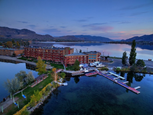
II.Natural Geography
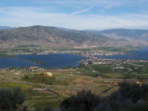
₋Osoyoos (/ɒˈsuːjuːs/, historically /ˈsuːjuːs/) is the southernmost town in the Okanagan Valley in British Columbia between Penticton and Omak. The town is 3.6 kilometres (2.2 mi) north of the United States border with Washington state and is adjacent to the Osoyoos Indian Reserve. The origin of the name Osoyoos was the word sẁiẁs (pronounced "soo-yoos") meaning "narrowing of the waters" in the local Okanagan language (Syilx'tsn). The "O-" prefix is not indigenous in origin and was attached by settler-promoters wanting to harmonize the name with other place names beginning with O in the Okanagan region (Oliver, Omak, Oroville, Okanogan). There is one local newspaper, the Osoyoos Times.
₋The town’s population of 5,085 (2016) swells in the summer months with seasonal visitors. Seniors (age 65 and over) comprise 43% of the town population. Another 1,858 people live around the town within Electoral Area A of the Regional District of Okanagan-Similkameen, and 762 more in the Osoyoos 1 Indian Reserve.
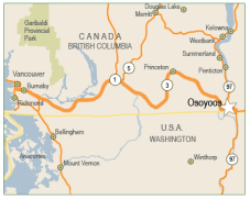
₋Osoyoos is situated on the east-west Crowsnest Highway (Highway 3) with a significant ascent out of the Okanagan Valley in either direction. The Crowsnest headed east begins with an 18 km (11 mi) switchback up the flank of the Okanagan Highland with a 685 m (2,247 ft) rise to the mining and ranching region of Anarchist Mountain, which is part of the Boundary Country (the stretch of rising highway is also referred to as Anarchist Mountain). Highway 3 westbound leads to Keremeos and the Similkameen Valley via Richter Pass. On Highway 97 south is a 24-hour border crossing between Canada and the United States between Osoyoos and Oroville, Washington. The Canada–United States border is located 4 km (2. 5 mi) south of the Highway 3 and 97 intersection on the northwest side of town.
₋The town is situated on Osoyoos Lake, which has a perimeter of 47.9 km (29.8 mi), an elevation of 276 m (906 ft), a maximum depth of 63 m (207 ft), and a mean depth of 14 m (46 ft). The lake’s elevation marks the lowest point in Canada of the Okanagan Valley.
III.ECONOMY
₋In Osoyoos, just 45.3 per cent of income comes from employment, while the provincial percentage is 70.8 per cent.
₋The median household income in Osoyoos in 2015 was $52,352, according to Statistics Canada.
₋This contrasts with medians of $69,995 for B.C. and $70,336 for all of Canada.
₋Website: https://www.osoyoostimes.com/osoyoos-incomes-lower-b-c-canada-poverty-less-widespread/#:~:text=In%20Osoyoos%2C%20just%2045.3%20per,%2470%2C336%20for%20all%20of%20Canada
IV.Industrial Characteristics
₋Although the fruit-growing possibilities were noticed by early settlers, the first commercial orchard in the area was not established until 1907, growing cherries, apricots, nectarines, peaches, plums, pears and apples. Osoyoos Orchard Limited was formed in 1920 and an irrigation project was planned which finally brought water to the west bench via “The Ditch” in 1927. The former shrub-steppe environment was transformed into a lush agricultural belt and Osoyoos promoted “the earliest fruit in Canada”.
₋Today, the area continues to produce tree fruits. Aside from tourism, agriculture is a major component of the local economy, as is evident by the abundant produce stands along Highways 3 and 97, and the numerous commercial orchards surrounding the town. With the growing popularity of viticulture, some of these orchards are being converted to vineyards, as the area is a major wine-producing region of Canada. After clearing of mainly sagebrush, parcels of bench land have been replanted for viticulture.
₋The vast majority of the land in the valley bottom surrounding the town is protected by the Agricultural Land Reserve which prevents valuable agricultural lands from being converted into other uses.
V.Attractions
1.Sẁiẁs Provincial Park
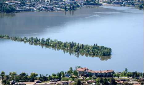
₋Sẁiẁs Provincial Park (formerly Haynes Point Provincial Park) is a provincial park in British Columbia, Canada, located on the west side of Osoyoos Lake in the town of Osoyoos, which is on the United States-Canada border at the southern end of the Okanagan region of British Columbia. Now approximately 38 ha. in size, the park was originally created in 1939 and has been decreased and then increased in size since then. The name was changed from Haynes Point to sẁiẁs, the original Okanagan (Syilx'tsn) name for the region, meaning "narrowing of the waters".
₋Haynes Point and adjacent Haynes Creek were named for John Carmichael Haynes (1831–1888). Haynes was "an Irishman who came to BC in 1858 and was police officer, customs officer, magistrate, assistant gold commissioner, government agent and county court judge in Similkameen, Osoyoos and Kootenay Districts for many years; member of the legislative council of the Colony of British Columbia, 1864-66, rancher at Osoyoos, 1866-88, accumulating 22,000 acres. Generally known as Judge Haynes."
₋Address: Okanagan-Similkameen A, BC V0H 1V0
₋Phone: (778) 437-2295
₋Website: http://bcparks.ca/explore/parkpgs/swiws/
2. Nk'Mip Desert Culture Centre
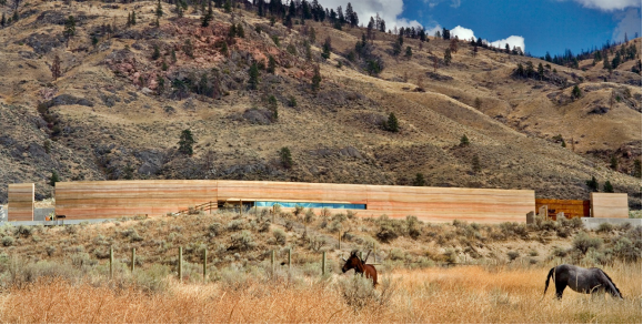
₋The Nk'Mip Desert Culture Centre ("Nk'mip" is pronounced "in-ka-meep") is an award-winning interpretive centre in Osoyoos, British Columbia, Canada, It is owned and operated by the Osoyoos Indian Band and is approximately 3 km (2 mi) north of the Canada–United States border. It is situated on the edge of one of the most endangered ecosystems in Canada, the northernmost point of the Great American Desert which extends southward to the Sonoran Desert in Mexico.
₋The mission of the Centre is to exhibit the Okanagan Desert and the culture of the Okanagan people, and to promote conservation efforts for desert wildlife. The Centre has helped to create several spin-off businesses, including a landscaping business, a greenhouse for indigenous plants, a website development business, and a community arts and crafts market.
₋The Centre includes both indoor and outdoor exhibits and trails. It is designed as an interactive learning environment with hands-on displays and two multi-media theatres. Exhibits include recreated examples of Aboriginal architecture structures: a Tipi, Pit-house, and Sweat lodge. The building is adjacent to a remnant of the desert, approximately 1,600 acres of which are being preserved as a conservation area. Trailheads lead to 50 km (30 mi) of desert paths leading to reconstructed examples of First Nations buildings and interpretive sculptures.
₋The Centre's Rattlesnake Research Program receives support from Environment Canada to study Western Rattlesnakes and Great Basin Gopher snakes. The snakes are tracked and studied by biologists using radio telemetry.
₋ The Centre was designed by Hotson Bakker Boniface Haden architects + urbanists (now DIALOG), and completed in 2006. The construction cost was $6.6 million for the 39,000 m2 (420,000 sq ft) (interior and exterior spaces) facility. The design is both an homage to the traditional winter dwellings of the Okanagan peoples and a literal integration into the natural landscape with a contemporary architectural design. The building is constructed partially underground with the desert landscape extending over the building’s planted (green) roof and the front of the building is constructed of a rammed earth facade. This rammed earth wall is constructed of local soils, concrete, and colour additives. At 80 m (260 ft) long, 5.5 m (18 ft) high, and 0.6 m (2 ft) thick, it is (as of 2014) the largest in North America. Its thickness and mass provide an insulating value of R-33 that help to provide a more stable indoor temperature than the large temperature swings of the surrounding desert climate. One architectural jurist described it: "the chameleon-like wall defines an ambiguous threshold between landscape and building."
₋Phone: +1 888-495-8555
₋Website: https://nkmipdesert.com/
3. Okanagan Desert
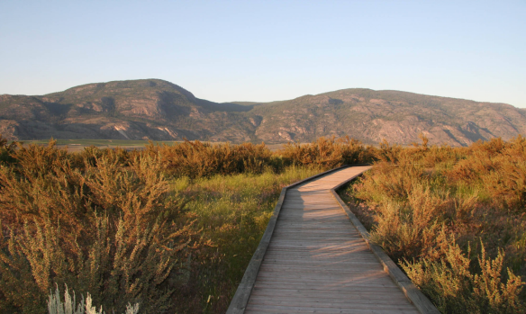
₋The Okanagan Desert is the common name for a semi-arid area located in the South Okanagan Valley region of British Columbia, Canada, primarily around the town of Osoyoos. Part of the area is called the Nk'mip Desert by the Osoyoos Indian Band, though the entire region, like other similar parts of the British Columbia Interior, is technically a semi-arid shrub-steppe.
₋South Okanagan shrub-steppe contains several species of plants and animals not found elsewhere in Canada. It is the presence of these specific plants in the Antelope-brush ecosystem that is claimed to make the area unique from other semi-desert areas in British Columbia. The South Okanagan shrub-steppe ecosystem is a habitat for 30% of the Red-listed and 46% of the Blue-listed vertebrates in British Columbia, with several listed as threatened or endangered. More than 24 invertebrates exist only in the Okanagan Desert, with an additional 80 species occurring nowhere else in Canada.
₋There are multiple groups or organizations located in the Okanagan Desert. The Osoyoos Band, a First Nations government located in British Columbia, runs the Nk'Mip Desert Cultural Centre as part of its resort and winery complex, which is located on the east side of Osoyoos. The Osoyoos Desert Society, a non-profit society founded in 1991, maintains the Osoyoos Desert Centre, a 67-acre nature interpretive facility 3 km (2 mi) north of Osoyoos off Highway 97. The Osoyoos Lake Water Quality Society – which focuses on the impact and relationship of the South Okanagan shrub-steppe ecosystem with Osoyoos Lake – is a community public relations organization.
₋Phone: +1 877-899-0897
₋Website: http://www.desert.org/
VI.History
₋Aboriginal people have lived in the Osoyoos area for thousands of years, as evidenced by rock and an oral tradition explaining their history before Europeans arrived to the valley in 1811.
₋The first Europeans to Osoyoos were fur traders working for the Pacific Fur Company, an American enterprise. They ventured up the Okanagan River to Osoyoos Lake and farther north. After the Hudson’s Bay Company took over the fur trade in 1821, the Okanagan Valley became a major trade route for supplies to inland forts of British Columbia and furs that were shipped south to the Columbia River and the Pacific to European and Asian markets. The final Hudson’s Bay Company brigade in 1860 was the end of an era, as gold rushes transformed the economy of the new Colony of British Columbia. As parties of miners headed for the Fraser goldfields via the Okanagan Trail, they commonly met conflict with the Okanagan people. The Dewdney Trail passed through Osoyoos on its way from Hope to the Kootenays. The Dewdney Trail now forms the backbone of the Crowsnest Highway.
₋Thousands of miners heading to the goldfields and drovers with large herds of livestock crossed the 49th parallel after 1858. A custom house was built in Osoyoos in 1861 with John Carmichael Haynes as the tax collector. Haynes was also the first pioneer settler who obtained land along the Okanagan River north of Osoyoos that had been part of the Osoyoos Indian Reserve established by the Joint Indian Reserve Commission in 1877. These lands, now known as the Haynes Lease lands, remain as an original house and barn.
₋Osoyoos was incorporated as a village in 1946 when the railway arrived and became a town in the 1980s.[citation needed] When the railway was discontinued, its station house and grounds were granted to the Osoyoos Sailing Club.
VII.Other Information
₋Business Support
₋When combined with our labour pool, infrastructure, and low overhead costs, Osoyoos' open door business support policy make it quick, easy, and less expensive to launch a new venture.
₋Osoyoos' quality of life and increasingly diversified economy make it easy to attract skilled, talented people - the core of any successful business. These people continually bring new energy to an existing pool of available skilled workers.
₋Osoyoos' Buena Vista Industrial Park features low-cost serviced lots that are available for purchase by private owners. A unique aspect of the Park is the ability to include a residential living space within your industrial project. Further space opportunities for commercial and tourism enterprises are also readily available.
₋The total costs of establishing and operating your business in Osoyoos are lower than many comparable communities in Canada or the United States. Investors can expect access to one of the lowest electric utility rates in North America, affordable housing prices, competitive property tax rates, and low labour costs.
₋Website: https://www.osoyoos.ca/content/about-osoyoos-1
VIII.Contact Information
₋Government
Mayor: Sue McKortoff
Governing Body: Osoyoos Town Council
₋City Hall
GENERAL INQUIRIES: 250.495.6515
FAX: 250.495.2400
TOLL FREE: 888.495.6515
EMAIL: info@osoyoos.ca
MAILING ADDRESS: Box 3010, Osoyoos BC V0H 1V0
₋Website: https://www.osoyoos.ca/content/contact-us
