Penticton, British Columbia 作者: 来源: 发布时间:2021-05-25
I.Population and Area
₋Area
Land: 1,724.95 km2
₋Population (2016)
Total: 33,761
Density: 801.8/km2 (2,077/sq mi)

II.Natural Geography
₋Penticton is a city in the Okanagan Valley of the Southern Interior of British Columbia, Canada, situated between Okanagan and Skaha lakes. In the 2016 Canadian Census, its population was 33,761, while its census agglomeration population was 43,432.
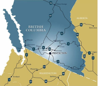
₋Penticton is located at the geographical coordinates of 49°29′28″N 119°35′19″W and covers an area of 42.10 km2 (16.25 sq mi), with a maximum north–south distance of 7 km (4.3 mi) wide between the Okanagan Lake to the north and Skaha Lake to the south; these lakes are part of the drainage system of the Okanagan River, a tributary of the Columbia River. Its borders are formed by Skaha Lake Road to the south and inwest, which changes to Highway 97 after city limits, Naramata Road to the east, and to the west, Highway 97. Penticton has an el evation of 385 m (1,263 ft), and is situated five hours from Seattle, Washington, or Vancouver, British Columbia, and eight hours from Calgary, Alberta, by highway.

₋ Transportation
₋Mass local transit in Penticton and Okanagan-Similkameen is offered by the South Okanagan-Similkameen Transit System under the BC Transit label, operating on six routes. There is also a service for people who are unable to use regular transit, HandyDART. The bus transportation system is funded by Penticton, Okanagan-Similkameen, and BC Transit. Its services are provided to points of interest, such as the Cherry Lane Shopping Centre Downtown Penticton. as well as traversing the distance lake to lake.
₋A number of parks and recreation transportation services are offered in the city, including trails, such as part of the Trans Canada Trail, and Kettle Valley Railway; the former runs through Canada, while the latter runs through Penticton, and Kelowna. Headquarters for the trail was chosen to be in Penticton in 1910, but the location burnt down in 1964.[82] The city has access to transportation corridors running north, south, east, and west, while the Highway 97 can also be accessed.
₋It is served by the Penticton Airport, a regional airport located 1.8 nautical miles (3.3 km; 2.1 mi) southwest of city centre. In 2018 a $6million upgrade to the facility was initiated to expand the departure and arrivals lounges as well as increase capacity for managing passenger flow. Although it has historically provided flights to several destinations, the airport currently offers flights to the Vancouver International Airport, which are provided by Air Canada Express; these services are provided three to four times daily, while the exception of Sunday, when two flights are available. WestJet Encore flies twice daily to its Calgary hub. The city is also home to the Penticton Water Aerodrome (TC LID: CAH8), a water aerodrome situated adjacent to the Penticton Airport and is home base to HNZ Topflight, an advanced helicopter flight training school operated by HNZ.
III.ECONOMY
₋The average salary in Penticton, British Columbia is C$19.89. Trends in wages decreased by -100.0 percent in Q1 2020. The cost of living in Penticton, British Columbia is 100 percent higher than the national average. The most popular occupations in Penticton, British Columbia are Administrative Assistant, Automotive Service Technician / Mechanic, and Licensed Practical Nurse (LPN) which pay between C$13.46 and C$30.74 per year. The most popular employers in Penticton, British Columbia are Interior Health, Loblaw's, and Loblaw's Company Limited.
₋Website: https://www.payscale.com/research/CA/Location=Penticton-British-Columbia/Salary
IV.Industrial Characteristics
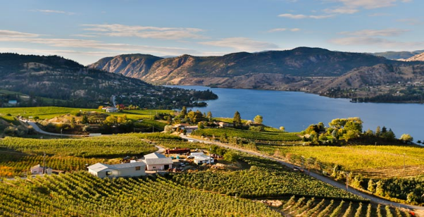
₋Penticton is ideally situated in the south of the Okanagan Valley, with over 100 wineries less than an hour’s drive away. Stress simply melts away as you leisurely travel the meandering country roads to some of the most scenic and award-winning wineries in the country. Relax on a vine-covered patio and soak in the views with a glass of your favourite red or white, or dine under the stars, estate winery style. The romance of wine country will take hold as you stroll through the lush vineyards, breathing in intoxicating scents – If only we could bottle this!
₋Website: https://www.visitpenticton.com/why-you-should-visit-us/
V.Attractions
1.Okanagan Lake

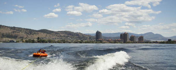
₋Okanagan Lake is a large, deep lake in the Okanagan Valley of British Columbia, Canada. The lake is 135 km (84 mi) long, between 4 and 5 km (2.5 and 3.1 mi) wide, and has a surface area of 348 km2.
₋Okanagan Lake is called a fjord lake as it has been carved out by repeated glaciations. Although the lake contains numerous lacustrine terraces, it is not uncommon for the lake to be 100 m deep only 10 m offshore. Major inflows include Mission, Vernon, Trout, Penticton, Equesis, Kelowna, Peachland and Powers Creeks. The lake is drained by the Okanagan River, which exits the lake's south end via a canal through the city of Penticton to Skaha Lake, whence the river continues southwards into the rest of the South Okanagan and through Okanogan County, Washington to its confluence with the Columbia.
₋The lake's maximum depth is 232 metres (761 ft) near Grant Island (Nahun Weenox). There is one other island known as Rattlesnake Island, much farther south by Squally Point. Some areas of the lake have up to 750 metres (2,460 ft) of glacial and post-glacial sediment fill which were deposited during the Pleistocene Epoch.
₋Notable features of the Okanagan Valley include terraces which were formed due to the periodic lowering of the lake's predecessor, glacial Lake Penticton. These terraces are now used extensively for agriculture such as fruit cultivation.
₋Cities bordering the lake include Vernon in the north, Penticton in the south, and Kelowna, as well as the municipalities of Lake Country (north of Kelowna), West Kelowna (west of Kelowna), Peachland (south of West Kelowna), and Summerland (north-west of Penticton). Unincorporated communities include Naramata (north-east of Penticton).
₋Various lake features include Rattlesnake Island (a small island east of Peachland), Squally Point (a popular cliff-diving area) & Fintry Delta on the west side.
₋The five-lane William R. Bennett Bridge, a floating bridge with a high boat passage arch connects Kelowna to the city of West Kelowna and the community of Westbank. This bridge replaced the three-lane floating Okanagan Lake Bridge on May 30, 2008, which had a lift span for passage of large boats.
₋Website: http://www.okanagan.com/
2.Okanagan Mountain Provincial Park

₋Okanagan Mountain Provincial Park is a provincial park within the Okanagan-Similkameen Regional District of British Columbia, Canada, focused on the mountain of the same name and located on the east side of Okanagan Lake, opposite Peachland and immediately south of the City of Kelowna. The park is one of the largest in the area, covering 110.38 square kilometres (42.62 sq mi). Most of the park is only accessible by foot, horseback, bicycle, or boat as motor vehicle access is restricted to BC Parks staff and technicians servicing the three telecommunications towers in the park.
₋The park comprises several trails, campsites (including six marine camp areas), lakes, and large areas of wilderness. Popular activities include hiking, camping, boating, mountain biking, and hunting (which is permitted).
₋Between 1975 and 1993, around 84.5 hectares (209 acres) of land now incorporated into Okanagan Mountain Provincial Park was donated by Dr. David Carruthers Murdoch through the Nature Trust of British Columbia.
₋Address: Lakeshore Rd, Okanagan-Similkameen E, BC
₋Phone: (250) 548-0076
₋Website: http://bcparks.ca/explore/parkpgs/okana_mt/
3.Skaha Lake

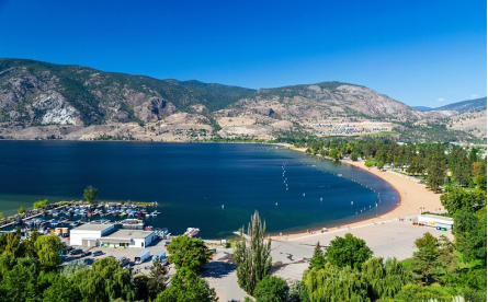
₋Skaha Lake, historically known as Dog Lake and originally Lac Du Chien, is a freshwater lake located along the course of the Okanagan River in the Okanagan Valley of British Columbia, Canada. It has a surface area of approximately 20 km², with a maximum depth of 55 metres. The lake is situated directly south of Okanagan Lake and forms the southern shoreline and boundary of the city of Penticton, British Columbia. The community of Okanagan Falls is located at its southern end, the community of Kaleden lies in the upland area to its west.
₋Website: https://www.penticton.ca/parks-recreation/parks/find-parks-and-gardens/skaha-lake-park
VI.History
₋The site of the city was first settled by the Syilx (Okanagan people), of the Interior Salish languages group, who initially named the community Phthauntac, meaning the "ideal meeting place", followed by Penticton, meaning a "place to stay forever", or officially "a place where people live year-round" in the Okanagan language. They settled around the city's two lakes: Skaha Lake and Okanagan Lake; the former was originally known as Dog Lake. Their descendants form the Penticton Indian Band, a First Nations government part of the Okanagan Nation Alliance situated near Penticton.
₋In 1866, Irishman Thomas Ellis and his family traveled to Penticton, and became the first white settlers. He started to develop a community by building a cattle empire, and planting fruit trees. The Penticton Hotel was established in 1892 by Ellis, who positioned it around the local government area, and its first road: Front Street. The sidewalks on the street were made from wood, with coal oil lamps being introduced to the sidewalk. Ellis and his relatives retired in 1892, and sold a portion of their land to property dealers. Around this time, a number of European fur traders traveled through Penticton and the surrounding communities.
₋The sternwheeler SS Aberdeen, which began service on Okanagan Lake in 1892, meant that more services could be shipped to the area. A group of residents formed their own local public government board for the community, by 1907, in the hopes of promoting the area. It was referred to as the Board of Trade, who attempted to specialize in arts, commerce, education, and recreation. Another sternwheeler was constructed at Okanagan Landing and launched that same year, the SS Okanagan, for use on Okanagan Lake, while other sternwheelers served Penticton and other communities on Skaha Lake.
₋An aerial view of Penticton; Skaha Lake can be seen in the foreground, while Okanagan Lake is visible in the background. Penticton Regional Airport's runway can also be seen.
₋Penticton was incorporated as a district municipality on December 31, 1908. Shortly after the district was incorporated, the fruit trees planted by Ellis, many of them apple trees, started to grow. Residents of the area packed fruit in boxes, so they could distribute it worldwide. In 1912, the Canadian Pacific Railway (CPR) developed the Incola Hotel for the city, which operated for approximately 70 years.
₋During World War I, the SS Sicamous came to the community, while the Kettle Valley Railway train service began operating, by moving specific passengers. In 1949, Penticton purchased the ship from the Canadian Pacific Railway. The Penticton Regional Airport was developed during World War II due to wartime military air transportation concerns, which acted as an emergency landing strip until its tarmac was completed. Its land was expropriated from the Penticton Indian Band in 1949 under the War Measures Act.
₋In 1948, a provincial highway opened between Hope and Princeton, which allowed access to Penticton, and created competition for the Kettle Valley Railway; headquarters for the railway were chosen to be in Penticton, in 1910, but the location burnt down in 1964. Much of the railroad's original route has been converted to a multi-use recreational trail, known as the Kettle Valley Rail Trail, which carries the Trans Canada Trail through this part of British Columbia. It was incorporated as a city on May 10, 1948, with the Governor General of Canada declaring this. Reeve Robert Lyon served Penticton as the first mayor, while Lord Alexander was made a freeman of the city.
VII.Other Information
₋Events
₋Penticton hosts many events annually, among them the Super League Penticton Triathlon, the Valley First Granfondo Axel Merckx Okanagan, the Okanagan Wine Festival, the Okanagan Children's Festival, Meadowlark Nature Festival, Which takes place on the May long weekend Fest-of-Ale BC, the Penticton Peach Festival (commonly known as "Peachfest"), the Miss Penticton Pageant, which takes place during the Penticton Peach Festival, the Pentastic Hot Jazz Festival, the Peach City Beach Cruise, and the Elvis Festival, which was featured in the Summer 2006 issue of British Columbia Magazine. Penticton was home to the Ironman Canada race from 1983 until 2012.
₋Education
₋Penticton is served by School District 67 Okanagan Skaha, a school district with education institutions also based in nearby communities Naramata, Kaleden, and Summerland; its head office is held in Penticton itself. The district administers children from kindergarten to grade 12 locally, those of which are between kindergarten to grade five attend elementary schools, while children in grades between grade six to eight attend middle schools; ninth to 12th graders are served by secondary schools. School District 67 Okanagan Skaha currently maintains 11 elementary schools, four middle schools, and three secondary schools, including Penticton Secondary School and Princess Margaret Secondary School. On June 30, 2016, School District 67 closed both McNicoll Park Middle School and West Bench Elementary School. During the 2016/2017 school year School District 67 operated 10 elementary schools, 3 middle schools, and 3 high schools. Penticton has three independent schools; Penticton Christian School, Holy Cross School, and Concordia Lutheran School.
₋The Conseil scolaire francophone de la Colombie-Britannique operates two Francophone schools: école Entre-lacs primary school and the école secondaire de Penticton.
₋The city is home to a Sprott Shaw College campus, and an Okanagan College campus, the latter of which, in 2010, had an enrollment of 610. It also contains the Okanagan Hockey School, which has had partnerships with professional hockey teams, such as the Vancouver Canucks.
₋The Penticton Public Library was founded in 1909, from 1948 to 1968 it was a part of the Okanagan Regional Library. In 1968 a successful referendum separated the library from the Okanagan Regional Library.
VIII.Contact Information
₋Government
Mayor: John Vassilaki
₋City Hall
₋Address: 171 Main Street, Penticton, BC V2A 5A9
₋TEL:
250-490-2400
250-490-2402
After hours emergencies: 250-490-2324
₋Website: https://www.penticton.ca/business-building/business-economic-development/economic-profile
