Alert Bay, British Columbia 作者: 来源: 发布时间:2021-03-30
I.Population and Area
₋Area
Land: 1.78 km2 (0.69 sq mi)
₋Population (2016)
Total: 489
Density: 270/km2 (710/sq mi)
II.Natural Geography
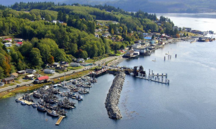
Alert Bay Overview & The Big House Near Alert Bay
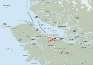
₋Alert Bay is a village on Cormorant Island, in the Regional District of Mount Waddington, British Columbia, Canada. 1,200-1,500 people live within the village.
₋Alert Bay has an oc eanic climate (Köppen Cfb) with a strong drying tendency in summer. Alert Bay is heavily moderated by the proximity to the Pacific Ocean and being located in the pathway of low-pressure systems from said ocean, heavy annual rainfall ensues. Winter is the wettest season, but snowfall is rare due to the average lows above freezing.
₋Volcanic features in the geography around Alert Bay are part of the Alert Bay Volcanic Belt. It appears to have been active in Miocene and Pliocene times. No Holocene eruptions are known, and volcanic activity in the belt has likely ceased.
III.ECONOMY
₋The average Alert Bay salary in Canada is $81,627 per year or $41.86 per hour. Entry level positions start at $32,663 per year while most experienced workers make up to $81,627 per year.
₋Website: https://neuvoo.ca/salary/?job=Alert%20Bay
IV.Industrial Characteristics
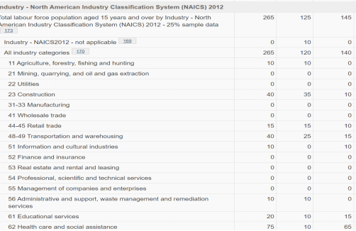
₋Its sheltered bay first attracted Kwakwaka'wakw (Kwakiutl), who used the area as a burial ground. The community probably began as a missionary outpost in 1878, although a saltery for salmon was established in 1870. A sawmill was constructed in 1886-87, and by 1896 steamships landed passengers and freight each week and serviced the saltery and a cannery. During World War I the logging industry became important to the war effort.
₋Website 1: https://www.thecanadianencyclopedia.ca/en/article/alert-bay
₋Website 2: https://www12.statcan.gc.ca/census-recensement/2016/dp-pd/prof/details/page.cfm?Lang=E&Geo1=CSD&Code1=5943008&Geo2=PR&Code2=59&SearchText=Alert%20Bay&SearchType=Begins&SearchPR=01&B1=All&GeoLevel=PR&GeoCode=5943008&TABID=1&type=0
V.Attractions
1.Cormorant Channel Marine Provincial Park
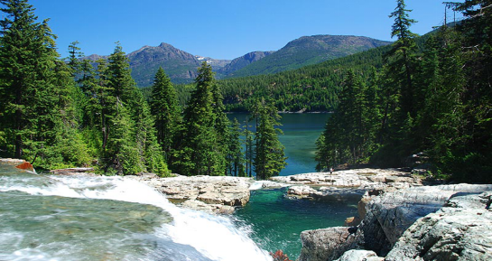
₋Cormorant Channel Marine Provincial Park is a provincial park in British Columbia, Canada, located in the Pearse Islands, a small archipelago to the east of Cormorant Island and the Village of Alert Bay at the western end of Johnstone Strait.
₋Cormorant Channel Marine Provincial Park is made up of a number of islands of the Pearse and Plumper groups of islands, situated at the western end of Johnstone Strait in between Hanson Island and Cormorant Island (Alert Bay). This marine-access park offers safe overnight anchorages for boaters traveling these waters.
₋Cormorant Channel is part of the core habitat of the northern resident Orca (killer whale) population. As such, it is one of the best places in the world to witness these magnificent creatures in their natural habitat.
₋In addition to whale watching and wildlife viewing, these undeveloped islands provide visitors with a number of recreational opportunities, including boating and kayaking. Cormorant Channel is part of the extremely popular Johnstone Strait sea kayaking circuit, and paddlers can easily find places to haul out and camp for the night among the many islands. The park also provides world class salt water fishing and scuba diving in the wildlife-rich tidal channels.
₋Website: http://bcparks.ca/explore/parkpgs/cormorant_ch/
2.U'mista Cultural Centre
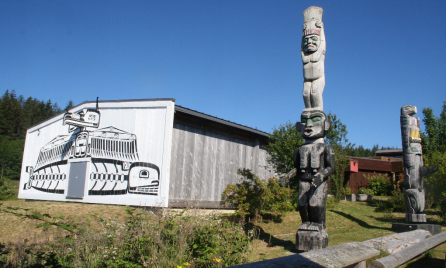
₋ One of the objectives of the Society was the development of a facility to carry out the aims of the society. The present facility was opened in November of 1980. The focus of the permanent collection is the "Potlatch Collection". The other permanent exhibits on display include description of the traditional ethnobiology of the Kwakwa̱ka̱ʼwakw and origin stories of the Kwakwa̱ka̱ʼwakw villages, as well as, historical and contemporary Kwakwa̱ka̱ʼwakw objects. Traveling exhibits of significance to the community are also displayed.
₋ The potlatch was banned in Canada between 1885 and 1951. The masks and other regalia that you see here were all confiscated after an illegal potlatch in 1921. After the ban was lifted, the Kwakwaka'wakw people fought for decades for the return of their sacred regalia that had ended up in museum and private collections around the world. Most of the regalia has come home and it is shown here at the U'mista Cultural Centre and at the Nuyumbalees Museum.
₋The U'mista Cultural Society was incorporated under the British Columbia Societies Act on March 22, 1974. Since that time, it has worked towards fulfilling the mandate to ensure the survival of all aspects of cultural heritage of the Kwakwa̱ka̱ʼwakw. To facilitate the accomplishment of this mandate, the Board of Directors, composed of any person who is an individual, family of honorary member and can trace ancestry to a member of any tribe of the Kwakwa̱ka̱ʼwakw, is responsible for developing, implementing and monitoring all policy.
₋Phone: 250-974-5403
₋Toll Free: 800-690-8222
₋Email: info@umista.ca
₋Website: https://www.umista.ca/pages/about-us
3.Alert Bay Ecological Park
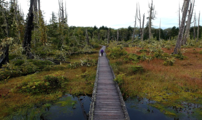
₋Located on the southside of Cormorant Island, above town off Alder Road, adjacent to the municipal campground, the Alert Bay Ecological Park is the island's best birding spot. This fascinating piece of terrain borders a dense, sun-dappled forest with an open marsh area. A combination of marked hiking trails and a boardwalk make both areas easy to explore.
₋The Ecological Park's "Gator Gardens"
₋The marsh within the Park is locally referred to as "gator gardens" because the dead trees and swampy bottomland remind some of the Florida Everglades.
₋Website: https://www.walkbc.ca/trail/ecological-park
VI.History
₋The citizens who share Cormorant Island's compact area have developed a philosophy of neighbourly harmony.
₋This is exemplified by the Alert Bay Accord between the Village of Alert Bay and the 'Namgis First Nation. It was signed in 1999 and renewed in 2012, and is the first agreement of its kind between a Municipality and First Nations Band in Canada. It describes our common goals and pledges mutual support in civic and cultural matters affecting both jurisdictions. Read the Accord here.
₋This mutually beneficial relationship has not always existed.
₋For thousands of years Cormorant Island, or Yalis, was populated by a great nation of seagoing people who called themselves the Kwakwaka’wakw. One of their most influential sub-groups lived along the rich valley of the river on Vancouver Island that modern maps may identify as the Nimpkish. These were the ‘Namgis.
₋Their principal village was built on terraces on the west side of the river mouth. It was here that a famous chief, Cheslakee, confronted and then befriended the captain of a tall-masted ship full of strange-looking men that anchored nearby in 1792. The ship was the Discovery and the captain’s name was Vancouver . His anchorage was in a sheltered cove on a nearby island. Around 1860, that island and its new European settlement would be named after the Navy ships HMS Alert and HMS Cormorant.
₋It was fortunate that Vancouver had a knack for diplomacy. The ‘Namgis were a proud and powerful people, populous thanks to the riches of their river, forest and sea.
₋In the period between first contact with European explorers and the beginning of European settlement, this coast was a profitable hunting ground for traders and exploiters. One good load of otter furs could make a ship owner rich for life. When the otter had been hunted almost to complete extinction, other resources were here for the taking --coal, gold, timber, whales, and fish in seemingly limitless abundance.
₋In the 1870 the huge runs of salmon in the Nimpkish River drew the attentions of two entrepreneurs, S.A. Spencer and Wesley Huson. They decided that Cormorant Island, opposite the river mouth, was a good location to set up a salmon saltery.
₋For a salmon saltery you need a supply of water. Spencer and Huson followed streams uphill to a boggy tract on the crown of the island. They dammed up the flow, probably as easily as felling huge trees across the rivulets. From the resulting pond they piped the water downhill to their packinghouse. There were also plenty of trees for building material.
₋The high water levels behind the makeshift dams drowned many trees, leaving a forest of dead standing wood. Wildfires raged through, leaving only the skeletons of the biggest trees. The roots of the charred carcasses of spruce, hemlock and fir soon rotted out. Only the durable red cedars resisted decay. Their bleached trunks still stand, 130 years after they died, creating an eerie scene that became known as “Gator Gardens”. It was renamed in 1998 the Alert Bay Ecological Park.
₋Alert Bay developed into the largest commercial fishing town on the central coastline. Spencer and Huson were joined by other fish processors and the harbour was crowded with gillnetters, long-liners and trollers. There were canneries here, as well as in many locations within a day’s sailing time of Alert Bay.
₋In a now-familiar story, what seemed like an inexhaustible resource was drastically depleted. Clear-cut logging along every stream destroyed spawning beds and over-fishing hastened the loss of the remnants. The awesome runs that once came to the Nimpkish River were mere trickles. The biggest runs of sockeye that now pass through Alert Bay ’s waters are from the tributaries of the Fraser River . The few fish boats still around are mostly high-tech machines that use electronics to find their targets.
₋Alert Bay has a small amount of people fishing these days, but we remember and learn from our past as we plan for the future.
₋Website: http://www.alertbay.ca/about-alert-bay
VII.Other Information
₋Cultural Connection
₋You're setting foot in a place that is becoming a global centre of First Nation culture. Archaeologists say that you can determine the wealth of a culture by the amount of art it produces and by that measure, Cormorant Island is incredibly wealthy. Besides what you see as you walk through town, the local First Nation artists produce art that is highly valued around the world.
₋Many of the 'Namgis civic buildings also incorporate bold elements of traditional coastal buildings, including the use of huge cedar trees in the architecture, such as in the 'Namgis Big House.
₋You can take in the T'sasala Cultural Group traditional dance performance in the Big House Thursdays, Fridays and Saturdays July to third week in August. The U’mista Cultural Centre, with its collection of priceless Kwakwaka'wakw potlatch regalia, is also a must-see. U’mista’s Potlatch Collection tells an epic story of resistance and resilience. The Centre opened in 1980 to house repatriated Kwakwaka'wakw ceremonial regalia that had been seized by government authorities in 1922. One of the most complete and important collections of its type in the world, U’mista’s Potlatch Collection is a source of great joy and pride for the Kwakwaka’wakw
₋Website: http://www.alertbay.ca/about-alert-bay
VIII.Contact Information
₋Government
Governing body: Alert Bay Village Council
Mayor: Rachel Blaney (NDP)
₋Address:
BAG SERVICE 2800,
15 MAPLE ROAD
ALERT BAY, BC V0N 1A0
₋Opening Hours: MON – FRI 8:30 AM-4:30 PM
₋T: (250) 974-5213
₋F: (250) 974-5470
₋E: OFFICECLERK@ALERTBAY.CA
₋Website: http://www.alertbay.ca/contact
