McBride, British Columbia 作者: 来源: 发布时间:2021-03-30
I.Population and Area
₋Area
Land: 4.64 km2 (1.79 sq mi)
₋Population (2016)
Total: 616
Density: 130/km2 (340/sq mi)

II.Natural Geography
McBride and the Fraser River
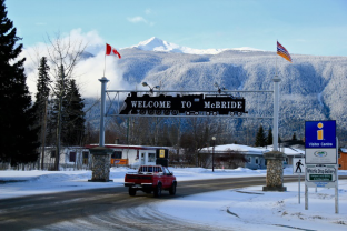
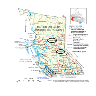
₋McBride is a village in the Robson Valley region of British Columbia, Canada. The village is located 210 km (130 mi) southeast of Prince George, British Columbia, and 166 km (103 mi) west of Jasper, Alberta. Incorporated in 1932, McBride is located in the Robson Valley surrounded by the Rocky Mountains and Cariboo Ranges.

III.ECONOMY
₋The average salary for a Front Desk Agent is $14.75 per hour in McBride, BC, which meets the national average. Salary estimates are based on 8 salaries submitted anonymously to Indeed by Front Desk Agent employees, users, and collected from past and present job advertisements on Indeed in the past 36 months. The typical tenure for a Front Desk Agent is less than 1 year.
₋Website: https://ca.indeed.com/salaries/front-desk-agent-Salaries,-McBride-BC
IV.Industrial Characteristics
₋Forestry
According to Pricewaterhouse Coopers, “Canadian paper and forest industry companies must undergo a fundamental transformation to survive in a world in which demand is unlikely to return to pre-recession levels”. A recent report, involving 33 executives in producing countries around the world, shows that executives in North America and Europe believe that the worst of the recession is over but they anticipate a slow recovery. However, recent developments in China are accelerating the recovery process. China has a 25% of world population and only 2% of the land base. Recently, China adopted new building codes allowing wood-frame construction in Shanghai. This is a breakthrough for the Canadian lumber industry. It is anticipated that the price of lumber will increase in the second half of 2010.
About 37% of McBride’s labour force relies on the forest industry. Although some efforts are being made by the mill owners to re-start their operations, the majority of forestry workers remain unemployed. Our survey indicated that 96.8% of respondents identify job creation as a main issue of concern. In addition, over 70% of respondents would support project subsidy-“depending on the project”.
₋Agriculture
Historically, agriculture played a strong role in the Robson Valley. The outlook for B.C. agriculture is positive, which should have an encouraging impact on the local food production. British Columbia enjoys an outstanding competitive advantage in Canada in terms of the diversity of food commodities and the commitment to food safety and environmental stewardship. In June of 2009, the Canadian Food Inspection Agency confirmed that Canada has achieved a national disease-free status for avian influenza, based on the standards of the World Organization for Animal Health. This opens-up an opportunity for local, commercial poultry production. During 2009, the Ministry of Agriculture and Lands announced a number of programs under the Growing Forward Agreement, which puts $553 million into B.C.’s agriculture sector over the term of the deal.
₋Tourism
The land area of the Northern British Columbia region stretches from the Queen Charlotte Islands in the west, to McBride in the east, and north to the Yukon and Alaska boarders, representing 61.8% of province’s total land area but contains only 6.1% of the province’s total private dwellings. Prince George is the largest community in the region with total population of 70,981. The region is diverse in its geographic features with spectacular mountain ranges, heavily forested valleys, alpine meadows, hot springs and glacial lakes. The Northern B.C. tourism region offers a diverse range of tourism products, including aboriginal arts & culture, fresh & saltwater fishing, canoeing, kayaking, white water rafting, skiing and snowmobiling. The population in the Northern B.C. region has decreased by 2.7% since the previous census in 2001. Total international customs entries to the region had also been steadily declining. Prince Rupert was the entry point for the greatest number of the overseas visitors to the region (55.6%) and the greatest percentage of the U.S. visitors to the region (77.7%). Decreases in the custom entries were reported for both: Prince Rupert and Stewart (1.8% and 19.6% respectively) however the volumes to Prince George increased by 115.7%. (compared to 2007).
₋Website: file:///C:/Users/adaxu/Downloads/2010-2015_Economic_Development_Action_Plan.pdf
V.Attractions
McBride Peak

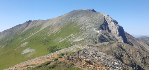
₋A steep, rough, dirt road switchbacks up the south side of the mountain and may only be driven in it’s entirety in the summer (depending on conditions). 4WD is recommended. This road provides access to the alpine meadows, at 2000m (6500ft) where there is a choice of short walks, longer hikes or climbs. Wonderful views of the Rocky Mt. Trench, Robson Valley and the village of McBride are possible. McBride Peak is immediately to the northeast of the parking area at the top of the 10.6 km road. There is also a clearing half-way up (1300m/4200ft) where it is possible to park and turn around, when conditions are limiting. The Halfway site offers picnic tables, fire rings and a pit toilet.
₋Travel East on Highway 16 till you cross the bridge that crosses the Fraser River on the east side of McBride. Take the second left onto Mountain View Road. Travel this road for about .6 km till you get Rainbow Road and turn right. Follow this road for about 200 m and take the left fork. This road makes numerous switchbacks in ascent. It is 5.5 km to the Halfway point where there is a nice view overlooking McBride. It is another 5.5km (total 10.6km) to reach the top. This is a single lane road so be careful with oncoming vehicles.
₋Website: https://caledoniaramblers.ca/trails/mcbride-peak
2.Kakwa Provincial Park

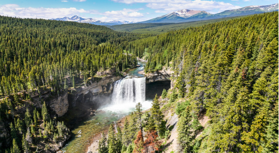
₋Kakwa Provincial Park and Protected Area is a 170,890 ha provincial park in northeastern British Columbia, Canada. There are significant amounts of fish fossils there. The tallest mountains are Mount Sir Alexander (3270 m) and Mount Ida (3189 m). Fishing in Kakwa Lake is permitted. Snowmobiling is permitted on trails, meadows, and along mountain sides.
₋The Kakwa River originates in Kakwa Lake, at the core of the park. It is named for Kakwa, the Cree word for porcupine.
₋Kakwa Provincial Park showcases ice-clad mountains, extensive alpine meadows and a section of the Continental Divide. Main physical features include Mount Sir Alexander (3270 m), Mount Ida (3189 m) and Kakwa Lake.
₋Summer activities include camping, hiking, fishing, and horseback trips. Winter activities include snowmobiling and wilderness ski tours. The wide range of species diversity gives excellent opportunity for wildlife viewing. Visitors interested in photography will appreciate the incredible beauty of the remote area. Winter visitors should note limited access routes apply.
₋Phone: +1 800-689-9025
₋Website: http://bcparks.ca/explore/parkpgs/kakwa/
3.Erg Mountain Provincial Park

₋Erg Mountain Provincial Park is a provincial park in British Columbia, Canada.
₋The park is spread over an area of 1,011 hectares. In its interior parts, starting from the slopes of the valley above the Upper Fraser Trench, the park consists of cedar hemlock forests. From these forests, the park continues on to higher altitudes, reaching the sub-alpine and alpine areas near the Erg Mountain. This mountain, which is an old hiking destination, is known for the magnificent vistas it offers of the Upper Fraser Valley along with the mountain range in the vicinity. When the weather is clear, the prominent Mount Sir Alexander is visible.
₋Website: http://bcparks.ca/explore/parkpgs/erg_mtn/
VI.History
₋McBride was founded in 1913 as Mile 90 of the Grand Trunk Pacific Railway. The village was named after the serving premier, Sir Richard McBride.
₋McBride's early industries were rail, shipping, forest harvesting and the agricultural development of the valley. In 1970 access to McBride changed with the opening of Highway 16 (Yellowhead), which enabled vehicles to travel through the valley. McBride is rich in farmland in the valley bottom, with a mix of forest and alpine surrounding the valley. This unique mixture allows McBride to be a prime location for many industries. Current industries for McBride are railroad, forestry, tourism, small businesses and agriculture. Barley, oats, forage crops and pasture are the main agricultural activities supported by dark gray Doré clay loam to clay and gray Rausch clay.
VII.Other Information
₋Community
₋The population of McBride was 616 at the 2016 Census. The population including the surrounding area is 1,586 Main Street has a variety of unique stores for visitors and locals to come and explore. The focal point of Main Street is the train station. The Grand Trunk Pacific Railway built the train station in 1913. A fire burnt the building down in 1918. The station was quickly rebuilt and reopened in 1919 on the original site. The last train dispatched from this station in 1989, but trains still ride through the station and pick up passengers on a daily basis. In 1996, the Village of McBride bought the station. The station houses the Whistle Stop, a gallery of quality work done by local artists and crafters, as well as McBride's Visitor Information Centre and a locally owned coffee shop The Beanery.
VIII.Contact Information
₋Government
Mayor: Eugene Runtz
₋Address:
Box 519
100 Robson Centre
McBride, B.C., V0J 2E0
Canada
₋Phone: 1-250-569-2229
₋Fax: 1-250-569-3276
₋Office hours: 8:30am-4:30pm Monday to Friday
₋Website: https://www.mcbride.ca/village-office/contact-us
