Lions Bay, British Columbia 作者: 来源: 发布时间:2021-03-29
I.Population and Area
₋Area
Land: 2.53 km2 (0.98 sq mi)
₋Population (2016)
Total: 1,334
Density: 526.5/km2 (1,364/sq mi)

II.Natural Geography
Lions Bay Overview
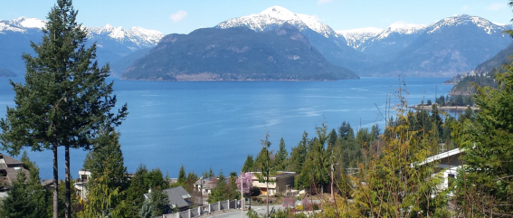
₋Lions Bay is a small, mostly residential community in British Columbia, Canada, located between Vancouver and Squamish on the steep eastern shore of Howe Sound. Lions Bay is the 35th least populous of BC's 162 municipalities by the 2016 census with a population of 1,334, and is 10th smallest by land area, at 2.51 km2. Originally a boat-access summer camping destination for Vancouverites, Lions Bay began to be permanently settled in the 1960s. The community incorporated as a village municipality in January 1971.

₋Local geology comprises lower-Cretaceous Gambier Group marine sedimentary and volcanic bedrock. Upslope, the headwaters of Magnesia, Alberta and Harvey Creeks are underlain by mid-Cretaceous era "Coast Plutonic Complex" rock, which has intruded into the older Gambier rocks. Outcrops primarily consist of greenish volcanic rock that is highly fractured (10 cm fracture spacing) with red oxidation on exposed surfaces. Prominent northwest trending faults and jointing create structural discontinuities that cause instability.
₋Geomorphology in the area is a product of recent glaciation and post-glacial erosion. The last, or Fraser, glaciation began 33,500 years ago and reached its peak 17,500 years ago. Ice retreat was delayed several thousand years by glaciers grounding, with several minor readvances . Glacial marine sedimentation (mud with stones dropped from icebergs) is believed to have ceased by 10,600 yr BP. The weight of ice had depressed the land surface, so during deglaciation, the sea flooded the land up to 220 m higher than it is today. Sea-level fell rapidly as the land rebounded, such that by about 10,000 years ago sea level was 10 m below present. By 5700 years ago it was at approximately modern levels. With the ice gone, water erosion and mass movement (debris slides, debris flows, rockfall, rock avalanches, snow avalanches) rapidly reworked unstable glacial sediments, declining in rate over time such that by no later than 7,500 years ago the landscape was similar to today. Steep rockfall aprons developed on mid to lower slopes. Magnesia, Alberta and Harvey Creeks are incised into their debris cones and alluvial fans have formed at their mouths into the ocean.
III.ECONOMY
₋With a population at 1,334 people, most inhabitants at Lions Bay, BC are above the low income cut-off, or the income a person must earn to be considered to be part of the low income group. Majority are also above the 2,016 national median income of $125,082 per year.
₋The household incomes chart shows how many household fall in each of the income brackets specified by Statistics Canada.
₋Website: https://townfolio.co/bc/lions-bay/demographics
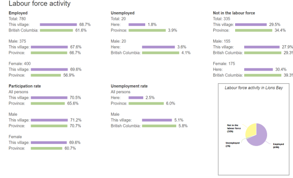
IV.Industrial Characteristics

₋Website: https://www.city-data.com/canada/Lions-Bay-Village-work.html
V.Attractions
The Lions

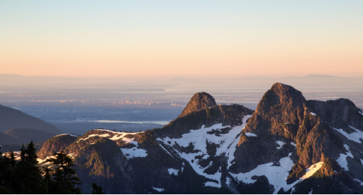
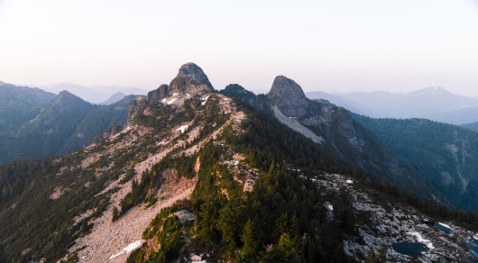
₋The Lions (Squamish: "Ch'ich'iyúy Elxwíkn" Twin Sisters) are a pair of pointed peaks (West Lion – 1,646 m (5,400 ft); East Lion – 1,606 m (5,269 ft)) along the North Shore Mountains in Metro Vancouver, British Columbia, Canada. They can be seen from much of the Greater Vancouver area, as far as Robert Burnaby Park in East Burnaby, south to parts of Surrey, and from the west on the Howe Sound Islands and the Sunshine Coast. Along with the Lions Gate Bridge named in their honour, these twin summits have become one of the most recognizable Vancouver landmarks. The city's BC Lions CFL football team is also named in their honour. Lions Gate Entertainment which was founded in Vancouver in July, 1997 is also named for the peaks.
₋According to an article by Steven Threndyle in The Greater Vancouver Book, "the earliest recorded climb of the West Lion in 1889 happened almost by accident. A group of hunters following a herd of goats found themselves at the top with no place to go but down. The hunting party was guided by Squamish First Nations Chief Joe Capilano. One of the members of the hunting team was Doctor Henry Bell-Irving, who asked Chief Capilano if he could time one of the chief's young natives to see how long it would take him to run from the base of the West Lion to the summit. The youth stripped completely naked, made the round trip ascent and descent in under 20 minutes.
₋With its steep granitic face, the East Lion was believed to be impossible to scale. That did not deter John Latta and his two brothers from setting out to climb the East Lion in 1903. Hearing that climbers often used ropes for mountaineering ascents, they packed one along but actually had no idea of how to use it. Their technique was to grasp the small shrubs and bushes growing out of the cracks in the rock. The Latta brothers also climbed the West Lion on their way out.
₋The Indigenous Squamish people named these two prominent peaks "Ch'ich'iyúy Elxwíkn" (translates as 'Twin Sisters'). These mountains remain sacred for their legal marker of a peace treaty, family lineage histories, and spiritual value. The two peaks were transformed by the Sky Brothers, or Transformers, after twin sisters that had married with Haida twins created the path for the war to end between the Squamish and Haida people. The families that made the Peace Treaty and married together still live in the Squamish and Haida Nations. Sometime around 1890, Judge John Hamilton Gray proposed that Canada rename the mountain peaks to lions couchant from heraldry.
₋Elevation: 1,654 m
₋First ascent: 1889
₋YouTube Video Link: https://www.youtube.com/watch?v=c_7u4TzbpTo
₋Website: https://www.alltrails.com/trail/canada/british-columbia/the-west-lion-hike
2.Unnecessary Mountain

₋Unnecessary Mountain, also called Mount Unnecessary, is a peak in the North Shore Mountains near Vancouver, British Columbia, Canada and a popular hiking destination. It is accessible via the Howe Sound Crest Trail and a direct route from Lions Bay.
₋The mountain is so named because of an "unnecessary" ascent over this mountain to reach The Lions.
₋In 2014, a rockslide killed 7-year-old Erin Kate Moore as she was hiking with a group on Unnecessary Mountain.
₋A second peak, also named Unnecessary Mountain, is located in Alberta northwest of the town of Pincher Creek.
₋Elevation: 1,548 m
₋Prominence: 123 m
₋Website: https://wandervancouver.com/unnecessary-mountain-via-lions-bay/
3.St. Mark’s Summit

₋St. Mark’s Summit is a peak along the Howe Sound Crest Trail that offers spectacular views of Howe Sound. Hiking the entire Howe Sound Crest Trail (which runs all the way to Porteau Cove) is more than a simple day hike, but heading to Saint Mark’s Summit is a worthy destination of its own and can be done in about 4 to 5 hours. From the peak you can see the islands of Howe Sound, the Tantalus Range and even Vancouver Island.
₋Overall, the hike isn’t too strenuous as there is only 460 m of elevation gain (one of the bonuses of starting from a ski resort parking lot) making St. Mark’s Summit one of the more popular hikes on the North Shore.
₋YouTube Video Link: https://youtu.be/F8DBplSBV5s
₋Website: https://www.outdoorvancouver.ca/featured-trail-st-marks-summit/
VI.History
₋In the early 1800s the Sea to Sky corridor was known as the Pemberton Trail and was briefly used as a cattle trail that ended at Burrard Inlet. As separate entities, Brunswick Beach and Lions Bay were first surveyed in 1908 and the first home built in the region was at Brunswick Beach in 1911. Logging was important to both communities for many years.
₋Recreational possibilities saw the construction of "Norman's Lodge" on Brunswick Point in 1929, and the development of St Mark's Church Camp on the Lions Bay waterfront (now the Marina) during the Second World War era. The latter area (100 acres) was sold (1945) for development and soon summer cottages sprang up along the foreshore.
₋Access to the two young communities of Lions Bay and Brunswick Beach was by boat until the opening of the railway in 1954 and the highway in 1958, when permanent residents including families with children began to arrive. Homes "up the hill" from the earlier waterfront cottages were built, and people shared four-party telephone lines to the rest of the world. Many cottages have now given way to magnificent large homes.
₋The Lions Bay "government" changed in 1971 from Water Improvement District status to Village Municipality, with a Mayor and four Councilors. Development of Kelvin Grove began in the 1980s, and Brunswick Beach and Lions Bay became united in 1999. Currently there are about 530 homes in the joint communities, with very little vacant land (25-30 lots) available for further development within present boundaries.
₋Website: https://www.lionsbay.ca/community/about-lions-bay/history
VII.Other Information
₋Amenities
₋Lions Bay Beach Park has restroom and change facilities, a sandy beach protected by a log boom, and a float. Pay parking is available. The Kelvin Grove Beach and Marine park 500 meters south also has a restroom and is a popular scuba destination and dog beach. Brunswick Beach a kilometer north has no facilities or visitor parking.
₋In the 2017–18 school year School District 45's Lions Bay School has about 30 K-3 pupils, down from peak levels in prior years of 60–80. After Grade 3, public school students bus to the K-7 Gleneagles Elementary (approx. 60 Lions Bay students out of 240) and the Grade 8–12 Rockridge Secondary (approx. 80 students from Lions Bay out of 800).
₋A volunteer fire department with 30+ highly trained members provides in-Village, wildfire and MVA rescue on the Sea-to-Sky Highway 99. Many members go on to permanent roles at professional departments; a training at Lions Bay Fire Rescue is considered one of the best available in western Canada.
₋Volunteer-maintained trails run through the community, and there is multi-day pay parking available at the Sunset trailhead to popular regional hikes.
₋Commercially there is a general store with Rural Liquor Outlet, a café (including on-tap beers for on-premise consumption), a real estate office, a 150-boat dry-storage marina and a marine service centre.
₋Infrastructure
₋Under license from the Province, water is drawn from intake weirs on Harvey and Magnesia Creeks, and disinfected in two modern dual-barrier (UV and chlorine) treatment plants. Surface supply is sufficient year-round for a consumption on the order of 300,000 USGPD in winter and 500,000 GPD in summer (a relatively high per-capita consumption rate regionally). With no reservoirs possible in the steep terrain, and projections calling for longer hotter summers with more intense rainfall, a long-range study underway in partnership with UBC's Civil Engineering department is modelling hydrological characteristics of the snowfields and groundwater catchments above the village, both to know when to increase short-term restrictions, and to understand long-term flow trends to have time to plan for deep wells, additional creek intakes or pipelining. In 2017 the municipality purchased the last piece of available waterfront land to hold in reserve for a future potential peak-shaving desalination plant.
₋100 houses in the Kelvin Grove neighbourhood are on central sewer connected to a small secondary treatment plant renewed in 2020; remaining residences and businesses rely on individual onsite wastewater systems.
₋As a member of the regional TransLink transit network, Lions Bay is served by the hourly 262 bus route. The provincial Sea-to-Sky Highway 99 (four lanes and three overpass/underpass intersections) and CN Rail (three at-grade road crossings) run through the community.
₋Lions Bay is not supplied with natural gas (the pipeline runs to the north, from Coquitlam over the North Shore mountains to Squamish), so wintertime heating is by baseboard and underfloor electrical resistance heating at standard tariffs, heat pumps, oil furnaces, propane, and wood heat in appliances ranging from open fireplaces to airtight and pellet stoves. Despite occasionally poor wintertime air quality, Lions Bay has negotiated reduced compliance with regional wood burning regulations starting in 2019.
VIII.Contact Information
₋Government
Mayor: Ron McLaughlin
₋Address: 5 Tidewater Way, Lions Bay, BC V0N 2E0
₋Working Hours: Monday - Friday:7:00 am - 3:30 pm
₋Email: reception@lionsbay.ca
Website: https://www.lionsbay.ca/contact
